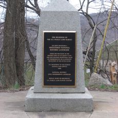
Congress Lands North of Old Seven Ranges, Federal land tract in Pennsylvania, United States.
Congress Lands North of Old Seven Ranges is a federal tract in northeastern Ohio spanning multiple counties with a systematic grid of numbered townships and ranges. The land divisions created under this survey system remain the foundation for property ownership and legal descriptions throughout the region.
Congress established this territory through the Land Ordinance of 1785, creating the first standardized surveying system in American history. This gridded approach to land division became the template for organizing all subsequent territories acquired by the United States.
The land distribution system implemented in this area influenced the development of farming communities and settlement patterns throughout the Midwest region.
This territory has no visitor facilities as it exists primarily as a historical survey concept visible in property records and land maps. To understand its layout and significance, consult county maps or visit specific towns and landmarks within the original survey boundaries.
Within each township, section 16 was specifically reserved for public schools and its proceeds funded local education throughout the region. This practice created one of the first nationwide systems to support schools through public land sales.
The community of curious travelers
AroundUs brings together thousands of curated places, local tips, and hidden gems, enriched daily by 60,000 contributors worldwide.