Enable Location

We need your location to show you interesting places around you

Discover nearby places

Find interesting locations and hidden gems around you

Precise directions

Get accurate directions and distances to places

Your location is never shared with other users. It's only used when you tap the location button.

Crawford Covered Bridge

Log in to your account

Start exploring — it's free

Trusted by 62,842 travelers worldwide

Continue with Google
Continue with Apple
or

We will send you a code to connect

By continuing, you accept our Terms and Conditions and our Privacy Policy

Check your inbox

We've sent a pincode in your inbox. Please enter the code below.

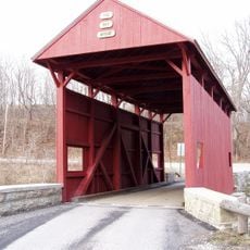
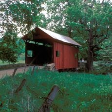
Crawford Covered Bridge, brug in de Verenigde Staten

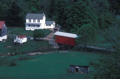
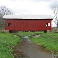
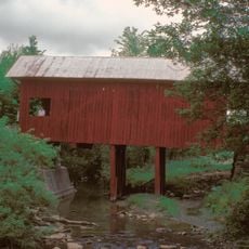
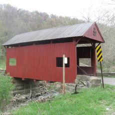
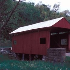
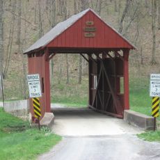
Crawford Covered Bridge is a wooden bridge in West Finley, Pennsylvania, that crosses Robinson Fork of Wheeling Creek and measures about 39 feet (12 meters) long. The structure with high sidewalls and sheet metal roof is supported by a Queen post truss design, keeping it stable and functional.

Built over a hundred years ago, the bridge is a rare example of traditional bridge building methods. It was added to the National Register of Historic Places in 1979 and has been maintained by the Washington County History & Landmarks Foundation since then.

The bridge carries the Crawford name from a local family of the area. Today it serves as a quiet place where visitors experience 19th century craftsmanship while walking across the wooden structure.

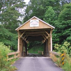
The site remains open to vehicle traffic today and is regularly inspected to ensure safety. The quiet surroundings with fields and trees make it a peaceful place to stop, walk, and take photographs.

The original wooden structure remains visible, showing the skill of builders who used simple tools more than a hundred years ago. Visitors can admire the crafted details like the crosswise floor planking and the reinforced high sidewalls that define its character.

The community of curious travelers

AroundUs brings together thousands of curated places, local tips, and hidden gems, enriched daily by 60,000 contributors worldwide.

Start exploring
Location
GPS coordinates
39.99903,-80.47268
Latest update
February 9, 2026 07:42
Around this place
Prabhupada's Palace of Gold
United States of America

Prabhupada's Palace of Gold

11.9 km
Ryerson Station State Park
United States of America

Ryerson Station State Park

13.3 km
Elm Grove Stone Arch Bridge
United States of America

Elm Grove Stone Arch Bridge

16.6 km
Claysville S Bridge
United States of America

Claysville S Bridge

18.8 km
Montgomery House
United States of America

Montgomery House

13.9 km
Edemar
United States of America

Edemar

19.4 km
Day Covered Bridge
United States of America

Day Covered Bridge

15.7 km
David Stewart Farm
United States of America

David Stewart Farm

5.8 km
Woodsdale-Edgewood Neighborhood Historic District
United States of America

Woodsdale-Edgewood Neighborhood Historic District

19.9 km
Carter Farm
United States of America

Carter Farm

18.5 km
Highland Park Historic District (Wheeling, West Virginia)
United States of America

Highland Park Historic District (Wheeling, West Virginia)

17.4 km
Fisher Site
United States of America

Fisher Site

4.4 km
Caldwell Tavern
United States of America

Caldwell Tavern

15.7 km
Scott Brownlee Covered Bridge
United States of America

Scott Brownlee Covered Bridge

8.1 km
National Road Corridor Historic District
United States of America

National Road Corridor Historic District

19 km
Wyit Sprowls Covered Bridge
United States of America

Wyit Sprowls Covered Bridge

1.6 km
Erskine Covered Bridge
United States of America

Erskine Covered Bridge

8.4 km
Plant's Covered Bridge
United States of America

Plant's Covered Bridge

5.4 km
Scott Covered Bridge
United States of America

Scott Covered Bridge

17.6 km
Taylorstown Historic District
United States of America

Taylorstown Historic District

19.6 km
Danley Covered Bridge
United States of America

Danley Covered Bridge

6.8 km
West Alexander Historic District
United States of America

West Alexander Historic District

12.1 km
Blaney Mays Covered Bridge
United States of America

Blaney Mays Covered Bridge

10 km
Sprowl's Covered Bridge
United States of America

Sprowl's Covered Bridge

5.8 km
Robert Parkinson Farm
United States of America

Robert Parkinson Farm

12 km
Woodridge
United States of America

Woodridge

19.8 km
Margaret Derrow House
United States of America

Margaret Derrow House

13.8 km
Oglebay Park
United States of America

Oglebay Park

19.8 km
Show the full map
« Crawford Covered Bridge - brug in de Verenigde Staten » is provided by Around Us (aroundus.com). Images and texts are derived from Wikimedia project under a Creative Commons license. You are allowed to copy, distribute, and modify copies of this page, under the conditions set by the license, as long as this note is clearly visible.

Discover hidden gems everywhere you go!

From secret cafés to breathtaking viewpoints, skip the crowded tourist spots and find places that match your style. Our app makes it easy with voice search, smart filtering, route optimization, and insider tips from travelers worldwide. Download now for the complete mobile experience.

Around Us App Screenshot

A unique approach to discovering new places

Le Figaro

All the places worth exploring

France Info

A tailor-made excursion in just a few clicks

20 Minutes

Around Us
Travel Guide & Maps
Download

Send to your phone

QR Code
1

Open the camera app on your mobile.

2

Point at the QR code with your camera. A notification will appear.

3

Tap the notification to open the link.