·

Enable Location

We need your location to show you interesting places around you

Discover nearby places

Find interesting locations and hidden gems around you

Precise directions

Get accurate directions and distances to places

Your location is never shared with other users. It's only used when you tap the location button.

Crawfordsville Senior High School

Log in to your account

Start exploring — it's free

Trusted by 62,647 travelers worldwide

Continue with Google
Continue with Apple
or

We will send you a code to connect

By continuing, you accept our Terms and Conditions and our Privacy Policy

Check your inbox

We've sent a pincode in your inbox. Please enter the code below.

Crawfordsville Senior High School, high school in Indiana, United States

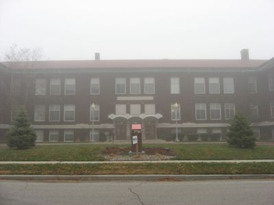
Crawfordsville Senior High School is a brick school building constructed in 1910 in Crawfordsville, Indiana, designed in the Prairie School style with symmetrical form, raised basement, and overhanging eaves. The structure features multiple windows and was expanded in 1914 with classrooms and an auditorium, followed by a gymnasium addition in 1921.

The school building was constructed in 1910 and served as the city's main high school for over 80 years until a new facility opened in 1993. The school gained recognition when its boys basketball team won the first Indiana High School Boys Basketball Tournament in 1911, marking a major moment in local sports history.

The stone panel above the main entrance reads 'A.D. * High School * 1910' and shows the community's commitment to education. The gymnasium door is carved with the word 'Gymnasium', reflecting how the building itself expresses the local value placed on learning and physical development.

The building sits on East Jefferson Street in downtown Crawfordsville and is easy to spot from the street. The property spans roughly 3 acres and is now called The Laurel Flats, housing apartments, offices, and a fitness center, which limits access to interior spaces.

The original gymnasium still contains wooden basketball floors, old scoreboards, and wooden bleacher seats from its time as a school facility. The basement was later fitted with a lap pool and whirlpool tub, showing how the historic building adapted to modern needs.

The community of curious travelers

AroundUs brings together thousands of curated places, local tips, and hidden gems, enriched daily by 60,000 contributors worldwide.

Start exploring
Location
GPS coordinates
40.03750,-86.89972
Latest update
February 9, 2026 08:21
Around this place
Shades State Park
United States of America

Shades State Park

19.5 km
General Lew Wallace Study
United States of America

General Lew Wallace Study

577 m
Ropkey Armor Museum
United States of America

Ropkey Armor Museum

9.1 km
Lusk Home and Mill Site
United States of America

Lusk Home and Mill Site

29.3 km
Portland Mills Covered Bridge
United States of America

Portland Mills Covered Bridge

25.4 km
Henry S. Lane House
United States of America

Henry S. Lane House

350 m
Col. Isaac C. Elston House
United States of America

Col. Isaac C. Elston House

564 m
Darlington Covered Bridge
United States of America

Darlington Covered Bridge

12 km
George Seybold House
United States of America

George Seybold House

21.8 km
Bethel AME Church of Crawfordsville
United States of America

Bethel AME Church of Crawfordsville

879 m
Thorntown Public Library
United States of America

Thorntown Public Library

27.1 km
T.C. Steele Boyhood Home
United States of America

T.C. Steele Boyhood Home

21.9 km
Saint John's Episcopal Church
United States of America

Saint John's Episcopal Church

310 m
McClelland-Layne House
United States of America

McClelland-Layne House

1.1 km
Normal Hall
United States of America

Normal Hall

16 km
Elston Grove Historic District
United States of America

Elston Grove Historic District

470 m
Crawfordsville Commercial Historic District
United States of America

Crawfordsville Commercial Historic District

2.9 km
Ashby
United States of America

Ashby

16.1 km
Samuel Brown House
United States of America

Samuel Brown House

25.2 km
Abijah O'Neall II House
United States of America

Abijah O'Neall II House

7.3 km
Colfax Carnegie Library
United States of America

Colfax Carnegie Library

26.4 km
William Fisher Polygonal Barn
United States of America

William Fisher Polygonal Barn

18.9 km
Linden Depot
United States of America

Linden Depot

17.3 km
Linden Depot Museum
United States of America

Linden Depot Museum

17.3 km
Cornstalk Covered Bridge
United States of America

Cornstalk Covered Bridge

19.6 km
Deer's Mill Covered Bridge
United States of America

Deer's Mill Covered Bridge

17 km
Pine Bluff Bridge
United States of America

Pine Bluff Bridge

29.2 km
Wallace Covered Bridge
United States of America

Wallace Covered Bridge

21.7 km
Show the full map
« Crawfordsville Senior High School - high school in Indiana, United States » is provided by Around Us (aroundus.com). Images and texts are derived from Wikimedia project under a Creative Commons license. You are allowed to copy, distribute, and modify copies of this page, under the conditions set by the license, as long as this note is clearly visible.

Discover hidden gems everywhere you go!

From secret cafés to breathtaking viewpoints, skip the crowded tourist spots and find places that match your style. Our app makes it easy with voice search, smart filtering, route optimization, and insider tips from travelers worldwide. Download now for the complete mobile experience.

Around Us App Screenshot

A unique approach to discovering new places

Le Figaro

All the places worth exploring

France Info

A tailor-made excursion in just a few clicks

20 Minutes

Around Us
Travel Guide & Maps
Download

Send to your phone

QR Code
1

Open the camera app on your mobile.

2

Point at the QR code with your camera. A notification will appear.

3

Tap the notification to open the link.