·

Enable Location

We need your location to show you interesting places around you

Discover nearby places

Find interesting locations and hidden gems around you

Precise directions

Get accurate directions and distances to places

Your location is never shared with other users. It's only used when you tap the location button.

Shades State Park

Log in to your account

Start exploring — it's free

Trusted by 62,690 travelers worldwide

Continue with Google
Continue with Apple
or

We will send you a code to connect

By continuing, you accept our Terms and Conditions and our Privacy Policy

Check your inbox

We've sent a pincode in your inbox. Please enter the code below.

Shades State Park

Shades State Park, State park in Montgomery, Parke, and Fountain Counties, US.

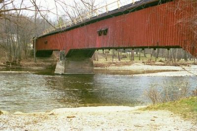
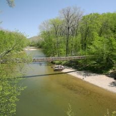
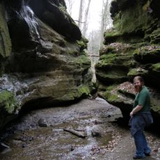
Shades State Park is a nature preserve with sandstone cliffs, deep ravines, and Sugar Creek running through its landscape. The grounds contain hiking trails, camping sites, and canoe routes that connect to different sections of the park.

The area was once a large resort destination in the late 1800s before becoming a state park in 1947 through a land donation. This shift from private leisure use to public protection reflects changing views about nature conservation.

The park draws hikers into its ravines and visitors who paddle the creek, shaping how people experience the landscape today. Canoe trails and walking paths reflect the ways locals and travelers choose to spend time in this forest setting.

The park has multiple camping areas with different setups along with picnic zones spread throughout the grounds. Bring sturdy shoes and water if you plan to hike, especially when exploring the wetter sections inside the ravines.

The Silver Cascade waterfall has an unusual outward curve that rarely appears in waterfalls. The Pine Hills Nature Preserve also contains the Devil's Backbone, a narrow rocky ridge formation that rises above the valley.

The community of curious travelers

AroundUs brings together thousands of curated places, local tips, and hidden gems, enriched daily by 60,000 contributors worldwide.

Start exploring
Location
Location
Inception
1947
GPS coordinates
39.94170,-87.09170
Latest update
December 7, 2025 20:48
Around this place
Turkey Run State Park
United States of America

Turkey Run State Park

11.7 km
Montgomery County Jail and Sheriff's Residence
United States of America

Montgomery County Jail and Sheriff's Residence

19.8 km
Crawfordsville Senior High School
United States of America

Crawfordsville Senior High School

19.5 km
Lusk Home and Mill Site
United States of America

Lusk Home and Mill Site

9.8 km
Jackson Covered Bridge
United States of America

Jackson Covered Bridge

17.7 km
Cox Ford Covered Bridge
United States of America

Cox Ford Covered Bridge

12.9 km
State Sanitorium Covered Bridge
United States of America

State Sanitorium Covered Bridge

18.4 km
Portland Mills Covered Bridge
United States of America

Portland Mills Covered Bridge

9 km
Narrows Covered Bridge
United States of America

Narrows Covered Bridge

9.8 km
Henry S. Lane House
United States of America

Henry S. Lane House

19.9 km
Wilkins Mill Covered Bridge
United States of America

Wilkins Mill Covered Bridge

13 km
Marshall Arch
United States of America

Marshall Arch

13.3 km
George Seybold House
United States of America

George Seybold House

8.4 km
Lancelot C. Ewbank House
United States of America

Lancelot C. Ewbank House

10.8 km
Bethel AME Church of Crawfordsville
United States of America

Bethel AME Church of Crawfordsville

19.7 km
T.C. Steele Boyhood Home
United States of America

T.C. Steele Boyhood Home

8.4 km
Joseph Finney House
United States of America

Joseph Finney House

17.9 km
Saint John's Episcopal Church
United States of America

Saint John's Episcopal Church

19.7 km
Rush Creek Covered Bridge
United States of America

Rush Creek Covered Bridge

19.6 km
McClelland-Layne House
United States of America

McClelland-Layne House

19.3 km
Richard Lieber Log Cabin
United States of America

Richard Lieber Log Cabin

11.7 km
Crawfordsville Commercial Historic District
United States of America

Crawfordsville Commercial Historic District

17.6 km
Abijah O'Neall II House
United States of America

Abijah O'Neall II House

13 km
Milligan Park Pool and Splash Pad
United States of America

Milligan Park Pool and Splash Pad

19.9 km
William Hill Polygonal Barn
United States of America

William Hill Polygonal Barn

19.7 km
Deer's Mill Covered Bridge
United States of America

Deer's Mill Covered Bridge

2.8 km
Wallace Covered Bridge
United States of America

Wallace Covered Bridge

6.6 km
Rocky Hollow-Falls Canyon Nature Preserve
United States of America

Rocky Hollow-Falls Canyon Nature Preserve

11 km
Show the full map
« Shades State Park - State park in Montgomery, Parke, and Fountain Counties, US » is provided by Around Us (aroundus.com). Images and texts are derived from Wikimedia project under a Creative Commons license. You are allowed to copy, distribute, and modify copies of this page, under the conditions set by the license, as long as this note is clearly visible.

Discover hidden gems everywhere you go!

From secret cafés to breathtaking viewpoints, skip the crowded tourist spots and find places that match your style. Our app makes it easy with voice search, smart filtering, route optimization, and insider tips from travelers worldwide. Download now for the complete mobile experience.

Around Us App Screenshot

A unique approach to discovering new places

Le Figaro

All the places worth exploring

France Info

A tailor-made excursion in just a few clicks

20 Minutes

Around Us
Travel Guide & Maps
Download

Send to your phone

QR Code
1

Open the camera app on your mobile.

2

Point at the QR code with your camera. A notification will appear.

3

Tap the notification to open the link.