Enable Location

We need your location to show you interesting places around you

Discover nearby places

Find interesting locations and hidden gems around you

Precise directions

Get accurate directions and distances to places

Your location is never shared with other users. It's only used when you tap the location button.

Marshall Arch

Log in to your account

Start exploring — it's free

Trusted by 62,630 travelers worldwide

Continue with Google
Continue with Apple
or

We will send you a code to connect

By continuing, you accept our Terms and Conditions and our Privacy Policy

Check your inbox

We've sent a pincode in your inbox. Please enter the code below.

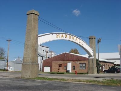
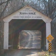
Marshall Arch, ceremonial gateway in Marshall, Indiana, USA

Marshall Arch is a wood structure supported by solid concrete pillars that spans across a road in downtown Marshall, Indiana, with a main span of about 51 feet (15.5 meters). The top clearance measures nearly 18 feet (5.5 meters), allowing regular traffic to pass through comfortably.

The arch was designed by Indiana architect Carroll Beeson in 1921 as his first project and was dedicated in late September that year. The ceremony honored local soldiers from World War I, transforming the structure into a memorial for the town's war losses.

The arch displays the town's name in stone letters on each side, creating a direct connection to local identity. It serves as a backdrop for community events and photographs, helping residents and visitors feel connected to Marshall's shared history and traditions.

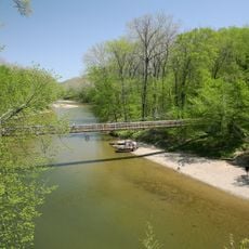
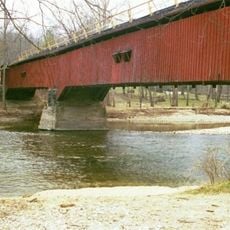
The arch is located on State Road 236 in downtown Marshall and is easily accessible for pedestrians and vehicles year-round. It makes a good spot for photographs and is near other historic sites and Turkey Run State Park, which offers natural attractions and covered bridges for further exploration.

The arch was Carroll Beeson's first architectural project, a young Indiana architect who went on to gain recognition. Despite its simple design, it became the defining landmark of an entire town and shows how a single structure can shape a community's identity.

The community of curious travelers

AroundUs brings together thousands of curated places, local tips, and hidden gems, enriched daily by 60,000 contributors worldwide.

Start exploring
Location
GPS coordinates
39.84760,-87.18761
Latest update
February 9, 2026 11:07
Around this place
Turkey Run State Park
United States of America

Turkey Run State Park

4.4 km
Shades State Park
United States of America

Shades State Park

13.3 km
Lusk Home and Mill Site
United States of America

Lusk Home and Mill Site

4.9 km
Jackson Covered Bridge
United States of America

Jackson Covered Bridge

8.9 km
Cox Ford Covered Bridge
United States of America

Cox Ford Covered Bridge

5.2 km
State Sanitorium Covered Bridge
United States of America

State Sanitorium Covered Bridge

8.3 km
Beeson Covered Bridge
United States of America

Beeson Covered Bridge

9.5 km
Portland Mills Covered Bridge
United States of America

Portland Mills Covered Bridge

8.6 km
Narrows Covered Bridge
United States of America

Narrows Covered Bridge

4.8 km
West Union Covered Bridge
United States of America

West Union Covered Bridge

12.7 km
Wilkins Mill Covered Bridge
United States of America

Wilkins Mill Covered Bridge

6.9 km
Billie Creek Covered Bridge
United States of America

Billie Creek Covered Bridge

9.7 km
Leatherwood Station Covered Bridge
United States of America

Leatherwood Station Covered Bridge

10.2 km
Melcher Covered Bridge
United States of America

Melcher Covered Bridge

14.2 km
Rockville Chautauqua Pavilion
United States of America

Rockville Chautauqua Pavilion

10.6 km
Crooks Covered Bridge
United States of America

Crooks Covered Bridge

13.7 km
George Seybold House
United States of America

George Seybold House

12.6 km
Lancelot C. Ewbank House
United States of America

Lancelot C. Ewbank House

8.7 km
Marshall Covered Bridge
United States of America

Marshall Covered Bridge

12.5 km
Catlin Covered Bridge
United States of America

Catlin Covered Bridge

7.6 km
T.C. Steele Boyhood Home
United States of America

T.C. Steele Boyhood Home

12.6 km
Joseph Finney House
United States of America

Joseph Finney House

7.3 km
Rush Creek Covered Bridge
United States of America

Rush Creek Covered Bridge

12.3 km
Rockville Historic District
United States of America

Rockville Historic District

10.1 km
Richard Lieber Log Cabin
United States of America

Richard Lieber Log Cabin

4.4 km
William Hill Polygonal Barn
United States of America

William Hill Polygonal Barn

6.6 km
Rocky Hollow-Falls Canyon Nature Preserve
United States of America

Rocky Hollow-Falls Canyon Nature Preserve

5.3 km
Turkey Run Suspension Bridge
United States of America

Turkey Run Suspension Bridge

4.8 km
Show the full map
« Marshall Arch - ceremonial gateway in Marshall, Indiana, USA » is provided by Around Us (aroundus.com). Images and texts are derived from Wikimedia project under a Creative Commons license. You are allowed to copy, distribute, and modify copies of this page, under the conditions set by the license, as long as this note is clearly visible.

Discover hidden gems everywhere you go!

From secret cafés to breathtaking viewpoints, skip the crowded tourist spots and find places that match your style. Our app makes it easy with voice search, smart filtering, route optimization, and insider tips from travelers worldwide. Download now for the complete mobile experience.

Around Us App Screenshot

A unique approach to discovering new places

Le Figaro

All the places worth exploring

France Info

A tailor-made excursion in just a few clicks

20 Minutes

Around Us
Travel Guide & Maps
Download

Send to your phone

QR Code
1

Open the camera app on your mobile.

2

Point at the QR code with your camera. A notification will appear.

3

Tap the notification to open the link.