·

Enable Location

We need your location to show you interesting places around you

Discover nearby places

Find interesting locations and hidden gems around you

Precise directions

Get accurate directions and distances to places

Your location is never shared with other users. It's only used when you tap the location button.

Melcher Covered Bridge

Log in to your account

Start exploring — it's free

Trusted by 62,643 travelers worldwide

Continue with Google
Continue with Apple
or

We will send you a code to connect

By continuing, you accept our Terms and Conditions and our Privacy Policy

Check your inbox

We've sent a pincode in your inbox. Please enter the code below.

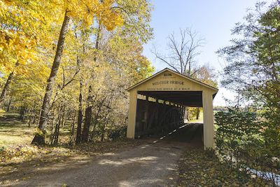
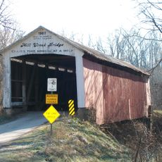
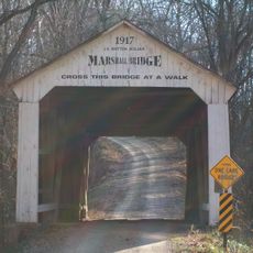
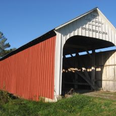
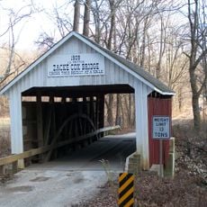
Melcher Covered Bridge, place in Indiana listed on National Register of Historic Places

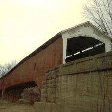
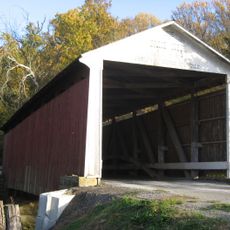
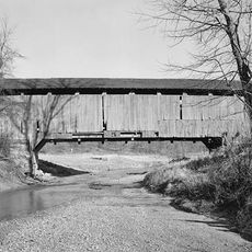
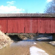
The Melcher Covered Bridge crosses Leatherwood Creek in Parke County, Indiana, along County Road 160 North near Montezuma. The structure spans about 83 feet and uses a Burr Arch truss system that combines arches with a timber frame for support.

The structure was built in 1896 by engineer J.J. Daniels, who was known for constructing numerous bridges throughout the region. It represents the era when wooden covered bridges were essential connections across rural landscapes before modern roads developed.

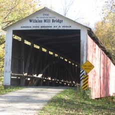
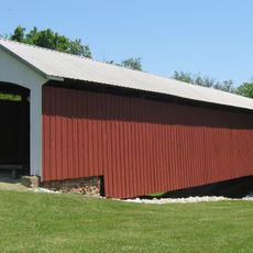
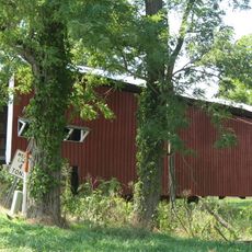
The bridge is known locally by several names - Melcher, Klondyke, and Marion - each reflecting stories of the surrounding communities and their connections. These names show how the crossing linked different places and activities, from a brick factory to a railroad station.

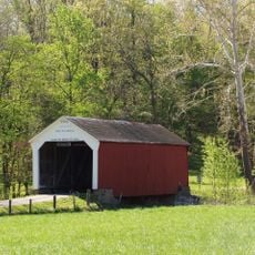
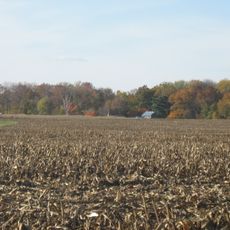
The bridge is easily accessible via County Road 160 North and can be crossed on foot or by vehicle, allowing visitors to view the structure from both inside and outside. The rural location offers adequate space nearby to stop and examine the construction without disrupting traffic.

The bridge goes by several local names including Klondyke and Marion, derived from nearby communities, with Marion named after an early brick factory in the area. These different names reflect how the crossing served as a vital link between distinct communities and the various economic activities they supported.

The community of curious travelers

AroundUs brings together thousands of curated places, local tips, and hidden gems, enriched daily by 60,000 contributors worldwide.

Start exploring
Location
Inception
1896
GPS coordinates
39.78889,-87.33495
Latest update
February 9, 2026 07:40
Around this place
Jackson Covered Bridge
United States of America

Jackson Covered Bridge

11.1 km
Cox Ford Covered Bridge
United States of America

Cox Ford Covered Bridge

14.3 km
Beeson Covered Bridge
United States of America

Beeson Covered Bridge

11.4 km
West Union Covered Bridge
United States of America

West Union Covered Bridge

7.4 km
Wilkins Mill Covered Bridge
United States of America

Wilkins Mill Covered Bridge

15 km
Sim Smith Covered Bridge
United States of America

Sim Smith Covered Bridge

1.7 km
Mecca Covered Bridge
United States of America

Mecca Covered Bridge

6.7 km
Billie Creek Covered Bridge
United States of America

Billie Creek Covered Bridge

11.4 km
Leatherwood Station Covered Bridge
United States of America

Leatherwood Station Covered Bridge

11.3 km
Possum Bottom Covered Bridge
United States of America

Possum Bottom Covered Bridge

10.2 km
Marshall Arch
United States of America

Marshall Arch

14.2 km
Rockville Chautauqua Pavilion
United States of America

Rockville Chautauqua Pavilion

9.1 km
Harry Evans Covered Bridge
United States of America

Harry Evans Covered Bridge

14.5 km
Crooks Covered Bridge
United States of America

Crooks Covered Bridge

14.4 km
Phillips Covered Bridge
United States of America

Phillips Covered Bridge

2.1 km
Mill Creek Covered Bridge
United States of America

Mill Creek Covered Bridge

13.5 km
Marshall Covered Bridge
United States of America

Marshall Covered Bridge

10.6 km
Catlin Covered Bridge
United States of America

Catlin Covered Bridge

8.3 km
Joseph Finney House
United States of America

Joseph Finney House

9.6 km
Zacke Cox Covered Bridge
United States of America

Zacke Cox Covered Bridge

11.2 km
Vermillion County Jail and Sheriff's Residence
United States of America

Vermillion County Jail and Sheriff's Residence

9.8 km
Rush Creek Covered Bridge
United States of America

Rush Creek Covered Bridge

12.4 km
Vermillion County Courthouse
United States of America

Vermillion County Courthouse

12.4 km
Rockville Historic District
United States of America

Rockville Historic District

9.4 km
Wabash Township Graded School
United States of America

Wabash Township Graded School

7.1 km
Newport Covered Bridge
United States of America

Newport Covered Bridge

14.1 km
Salem Methodist Episcopal Church
United States of America

Salem Methodist Episcopal Church

8.4 km
William Hill Polygonal Barn
United States of America

William Hill Polygonal Barn

7.7 km
Show the full map
« Melcher Covered Bridge - place in Indiana listed on National Register of Historic Places » is provided by Around Us (aroundus.com). Images and texts are derived from Wikimedia project under a Creative Commons license. You are allowed to copy, distribute, and modify copies of this page, under the conditions set by the license, as long as this note is clearly visible.

Discover hidden gems everywhere you go!

From secret cafés to breathtaking viewpoints, skip the crowded tourist spots and find places that match your style. Our app makes it easy with voice search, smart filtering, route optimization, and insider tips from travelers worldwide. Download now for the complete mobile experience.

Around Us App Screenshot

A unique approach to discovering new places

Le Figaro

All the places worth exploring

France Info

A tailor-made excursion in just a few clicks

20 Minutes

Around Us
Travel Guide & Maps
Download

Send to your phone

QR Code
1

Open the camera app on your mobile.

2

Point at the QR code with your camera. A notification will appear.

3

Tap the notification to open the link.