Enable Location

We need your location to show you interesting places around you

Discover nearby places

Find interesting locations and hidden gems around you

Precise directions

Get accurate directions and distances to places

Your location is never shared with other users. It's only used when you tap the location button.

Cumberland Valley Railroad Bridge

Log in to your account

Start exploring — it's free

Trusted by 65,868 travelers worldwide

Continue with Google
Continue with Apple
or

We will send you a code to connect

By continuing, you accept our Terms and Conditions and our Privacy Policy

Check your inbox

We've sent a pincode in your inbox. Please enter the code below.

Cumberland Valley Railroad Bridge
Discussion Reviews 1 Photos
4.8k Popularity

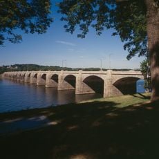
Cumberland Valley Railroad Bridge, Railroad bridge in Cumberland County, United States.

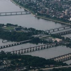
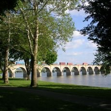
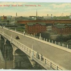
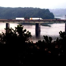
The Cumberland Valley Railroad Bridge is a concrete railway bridge that crosses the Susquehanna River, connecting downtown Harrisburg to Cumberland County by way of City Island. It spans the water in a series of arches and follows a plain functional style common to early concrete construction of the 20th century.

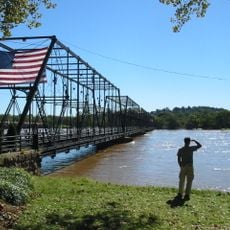
A first wooden bridge opened at this crossing in 1839 to serve the growing railroad traffic of the region, and after several rebuilds it was replaced by the current concrete structure finished in 1916. That transition marked a shift from older wood and iron construction toward modern concrete engineering.

The bridge passes over City Island, a river island now used as a public park where families from Harrisburg spend summer days. Visitors to the island can see the old rail crossing up close, standing quietly above the water between two shores.

The bridge has not been in active use since the late 1980s and cannot be crossed by train. It is best seen from City Island or from the riverbanks along the Susquehanna, where the full structure is visible without obstruction.

Shortly after the concrete bridge opened in 1916, President Woodrow Wilson was among the first to cross it. That detail is rarely mentioned today, even though it gives the structure a small but real place in American presidential history.

The community of curious travelers

AroundUs brings together thousands of curated places, local tips, and hidden gems, enriched daily by 60,000 contributors worldwide.

Start exploring
Inception
1916
GPS coordinates
40.25230,-76.88510
Latest update
March 3, 2026 08:13
Around this place
Pennsylvania State Capitol
United States of America

Pennsylvania State Capitol

1.4 km
City Island
United States of America

City Island

397 m
Walnut Street Bridge
United States of America

Walnut Street Bridge

584 m
Pennsylvania State Capitol Complex
United States of America

Pennsylvania State Capitol Complex

1.4 km
Philadelphia & Reading Railroad Bridge
United States of America

Philadelphia & Reading Railroad Bridge

397 m
Whitaker Center for Science and the Arts
United States of America

Whitaker Center for Science and the Arts

976 m
United States of America

Commonwealth

1.4 km
State Street Bridge
United States of America

State Street Bridge

1.7 km
Cathedral of Saint Patrick
United States of America

Cathedral of Saint Patrick

1.3 km
Simon Cameron House
United States of America

Simon Cameron House

717 m
Ronald Reagan Federal Building
United States of America

Ronald Reagan Federal Building

1.1 km
Market Street Bridge
United States of America

Market Street Bridge

491 m
St. Stephen's Episcopal Cathedral
United States of America

St. Stephen's Episcopal Cathedral

939 m
Dauphin County Courthouse
United States of America

Dauphin County Courthouse

707 m
Harris Switch Tower
United States of America

Harris Switch Tower

1.5 km
Mulberry Street Bridge
United States of America

Mulberry Street Bridge

1.3 km
Harrisburg Midtown Arts Center
United States of America

Harrisburg Midtown Arts Center

1.8 km
Old Midtown Historic District
United States of America

Old Midtown Historic District

1.7 km
Harrisburg Technical High School
United States of America

Harrisburg Technical High School

1.3 km
John Wormley House
United States of America

John Wormley House

1.4 km
William R. Griffith House
United States of America

William R. Griffith House

921 m
Harrisburg Historic District
United States of America

Harrisburg Historic District

810 m
William Seel Building
United States of America

William Seel Building

1.1 km
State Museum of Pennsylvania
United States of America

State Museum of Pennsylvania

1.5 km
M. Harvey Taylor Memorial Bridge
United States of America

M. Harvey Taylor Memorial Bridge

1.6 km
John Harris Bridge
United States of America

John Harris Bridge

777 m
Old Downtown Harrisburg Commercial Historic District
United States of America

Old Downtown Harrisburg Commercial Historic District

1 km
Kunkel Building
United States of America

Kunkel Building

1 km
Show the full map
Reviews
Share your experience

No review yet

Discussions
Start a discussion...

No discussion yet

« Cumberland Valley Railroad Bridge - Railroad bridge in Cumberland County, United States » is provided by Around Us (aroundus.com). Images and texts are derived from Wikimedia project under a Creative Commons license. You are allowed to copy, distribute, and modify copies of this page, under the conditions set by the license, as long as this note is clearly visible.

Discover hidden gems everywhere you go!

From secret cafés to breathtaking viewpoints, skip the crowded tourist spots and find places that match your style. Our app makes it easy with voice search, smart filtering, route optimization, and insider tips from travelers worldwide. Download now for the complete mobile experience.

Around Us App Screenshot

A unique approach to discovering new places

Le Figaro

All the places worth exploring

France Info

A tailor-made excursion in just a few clicks

20 Minutes

Around Us
Travel Guide & Maps
Download

Send to your phone

QR Code
1

Open the camera app on your mobile.

2

Point at the QR code with your camera. A notification will appear.

3

Tap the notification to open the link.