Enable Location

We need your location to show you interesting places around you

Discover nearby places

Find interesting locations and hidden gems around you

Precise directions

Get accurate directions and distances to places

Your location is never shared with other users. It's only used when you tap the location button.

DeSoto Bridge

Log in to your account

Start exploring — it's free

Trusted by 61,454 travelers worldwide

Continue with Google
Continue with Apple
or

We will send you a code to connect

By continuing, you accept our Terms and Conditions and our Privacy Policy

Check your inbox

We've sent a pincode in your inbox. Please enter the code below.

DeSoto Bridge

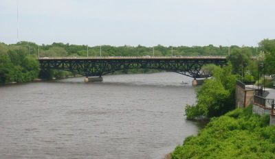
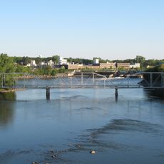
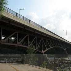
DeSoto Bridge, Deck arch bridge in St. Cloud, United States.

Description

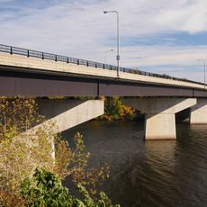
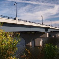
The DeSoto Bridge is an arch bridge that crosses the Mississippi River in St. Cloud and is constructed from dark-toned steel. The structure spans approximately 270 meters and is about 21 meters wide, with pronounced arches that emerge from the elevated banks on both sides.

History

The bridge was built in 1958 by the Minnesota Department of Transportation to provide a four-lane crossing of the Mississippi River. The project was part of Minnesota's efforts to modernize the region's transportation infrastructure in the mid-20th century.

Culture

The bridge takes its name from Hernando de Soto, the Spanish explorer who traveled through the region in the 16th century. The name connects the structure to the early exploration history of the Mississippi Valley.

Practical

The bridge serves as a major traffic route in St. Cloud and offers pedestrian and bicycle access across the river. Views of the water and surrounding landscape are best during daytime crossings when natural light illuminates the river valley below.

Did you know?

The dark gray steel material gives the bridge an unusual appearance that sets it apart from typical highway bridges in the region. This characteristic coloring reflects design choices that became more common in American bridge construction over time.

Location
Inception
1958
Official opening
1958
GPS coordinates
45.56110,-94.15190
Latest update
December 14, 2025 09:41

AroundUs brings together thousands of curated places, local tips, and hidden gems, enriched daily by 60,000 contributors worldwide. Discover all places nearby (St. Cloud).

Around this place
Minnesota Correctional Facility – St. Cloud
United States of America

Minnesota Correctional Facility – St. Cloud

3.4 km
Bridge of Hope
United States of America

Bridge of Hope

5.1 km
Munsinger Gardens and Clemens Gardens
United States of America

Munsinger Gardens and Clemens Gardens

1.3 km
Saint Benedict's Monastery
United States of America

Saint Benedict's Monastery

13 km
Cathedral of Saint Mary
United States of America

Cathedral of Saint Mary

769 m
St. Cloud Dam
United States of America

St. Cloud Dam

1.5 km
Church of St. Joseph-Catholic
United States of America

Church of St. Joseph-Catholic

13 km
Sartell Bridge
United States of America

Sartell Bridge

7.2 km
Foley–Brower–Bohmer House
United States of America

Foley–Brower–Bohmer House

486 m
Old Sartell Bridge
United States of America

Old Sartell Bridge

7.5 km
Veterans Bridge
United States of America

Veterans Bridge

396 m
Riverview Hall
United States of America

Riverview Hall

1.1 km
St. Cloud Rail Bridge
United States of America

St. Cloud Rail Bridge

536 m
Granite City Crossing
United States of America

Granite City Crossing

4 m
Church of St. Mary Help of Christians-Catholic
United States of America

Church of St. Mary Help of Christians-Catholic

9.1 km
Sauk Rapids Bridge
United States of America

Sauk Rapids Bridge

3.1 km
Sauk Rapids Regional Bridge
United States of America

Sauk Rapids Regional Bridge

3.3 km
First National Bank
United States of America

First National Bank

512 m
John N. Bensen House
United States of America

John N. Bensen House

665 m
Chancery House
United States of America

Chancery House

166 m
Michael Majerus House
United States of America

Michael Majerus House

864 m
Cota Round Barns
United States of America

Cota Round Barns

16.1 km
First State Bank
United States of America

First State Bank

13 km
Francis Arnold House
United States of America

Francis Arnold House

3.8 km
Nehemiah P. Clarke House
United States of America

Nehemiah P. Clarke House

308 m
Fifth Avenue Commercial Buildings
United States of America

Fifth Avenue Commercial Buildings

419 m
Stearns County Courthouse
United States of America

Stearns County Courthouse

828 m
Stearns History Museum
United States of America

Stearns History Museum

4.2 km
Show the full map
« DeSoto Bridge - Deck arch bridge in St. Cloud, United States » is provided by Around Us (aroundus.com). Images and texts are derived from Wikimedia project under a Creative Commons license. You are allowed to copy, distribute, and modify copies of this page, under the conditions set by the license, as long as this note is clearly visible.

Discover hidden gems everywhere you go!

From secret cafés to breathtaking viewpoints, skip the crowded tourist spots and find places that match your style. Our app makes it easy with voice search, smart filtering, route optimization, and insider tips from travelers worldwide. Download now for the complete mobile experience.

Around Us App Screenshot

A unique approach to discovering new places

Le Figaro

All the places worth exploring

France Info

A tailor-made excursion in just a few clicks

20 Minutes

Around Us
Travel Guide & Maps
Download

Send to your phone

QR Code
1

Open the camera app on your mobile.

2

Point at the QR code with your camera. A notification will appear.

3

Tap the notification to open the link.