Enable Location

We need your location to show you interesting places around you

Discover nearby places

Find interesting locations and hidden gems around you

Precise directions

Get accurate directions and distances to places

Your location is never shared with other users. It's only used when you tap the location button.

Log in to your account

Start exploring — it's free

Trusted by 62,930 travelers worldwide

Continue with Google
Continue with Apple
or

We will send you a code to connect

By continuing, you accept our Terms and Conditions and our Privacy Policy

Check your inbox

We've sent a pincode in your inbox. Please enter the code below.

Diamond Hill Reservoir
Discussion Reviews Photo
1.4k Popularity

Diamond Hill Reservoir, reservoir in Rhode Island

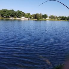
Diamond Hill Reservoir is a large water body in Cumberland, Rhode Island, built to store and supply drinking water to nearby communities. The facility includes an earthen dam that holds back the Abbott Run stream and is operated by Pawtucket's Water Supply Board.

The reservoir was established in 1971 when an earthen dam was constructed across the Abbott Run to manage the region's water supply. It has served the local communities for more than 50 years as a core part of the water infrastructure system.

The area around the reservoir is quiet and open, offering space for walking, birdwatching, or peaceful outdoor time. The natural surroundings with trees and water views are easy to access for visitors looking for a calm setting.

The reservoir is defined by an earthen dam standing about 24 meters high with substantial length. This practical structure is less known than decorative dams but forms the backbone of the region's water management system.

The community of curious travelers

AroundUs brings together thousands of curated places, local tips, and hidden gems, enriched daily by 60,000 contributors worldwide.

Start exploring
Location
GPS coordinates
41.98970,-71.39850
Latest update
February 9, 2026 08:18
Around this place
Cumberlandite
United States of America

Cumberlandite

4.9 km
Angle Tree Stone
United States of America

Angle Tree Stone

2.8 km
Providence Zen Center
United States of America

Providence Zen Center

3.4 km
Mount Saint Mary's Abbey
United States of America

Mount Saint Mary's Abbey

5.7 km
Attleborough Falls Historic District
United States of America

Attleborough Falls Historic District

7 km
Arnold Mills Historic District
United States of America

Arnold Mills Historic District

1.2 km
Lewis Tower House
United States of America

Lewis Tower House

5.4 km
Falls Fire Barn Museum
United States of America

Falls Fire Barn Museum

7.2 km
Ashton Historic District
United States of America

Ashton Historic District

6.5 km
North Attleborough Town Center Historic District
United States of America

North Attleborough Town Center Historic District

5.4 km
Woodcock-Hatch-Maxcy House Historic District
United States of America

Woodcock-Hatch-Maxcy House Historic District

5.6 km
Old Ashton Historic District
United States of America

Old Ashton Historic District

6.6 km
Berkeley Mill Village
United States of America

Berkeley Mill Village

7 km
South Washington Street Historic District
United States of America

South Washington Street Historic District

5.5 km
Old Town Historic District
United States of America

Old Town Historic District

7 km
Attleborough Falls Gasholder Building
United States of America

Attleborough Falls Gasholder Building

6.7 km
The Codding Farm
United States of America

The Codding Farm

4.7 km
John Cole Farm
United States of America

John Cole Farm

682 m
Cottage-Freeman Historic District
United States of America

Cottage-Freeman Historic District

7.7 km
Commonwealth Avenue Historic District
United States of America

Commonwealth Avenue Historic District

7.6 km
Ballou-Weatherhead House
United States of America

Ballou-Weatherhead House

3.8 km
Whipple-Cullen House and Barn
United States of America

Whipple-Cullen House and Barn

7.5 km
Burlingame-Noon House
United States of America

Burlingame-Noon House

5.1 km
Whipple-Jenckes House
United States of America

Whipple-Jenckes House

3.7 km
Ballou House
United States of America

Ballou House

7.8 km
Towne Street Historic District
United States of America

Towne Street Historic District

7.4 km
Barbara Road Beach
United States of America

Barbara Road Beach

6.4 km
Whiting's Pond Beach
United States of America

Whiting's Pond Beach

5.2 km
Show the full map
Reviews
Share your experience

No review yet

Discussions
Start a discussion...

No discussion yet

« Diamond Hill Reservoir - reservoir in Rhode Island » is provided by Around Us (aroundus.com). Images and texts are derived from Wikimedia project under a Creative Commons license. You are allowed to copy, distribute, and modify copies of this page, under the conditions set by the license, as long as this note is clearly visible.

Discover hidden gems everywhere you go!

From secret cafés to breathtaking viewpoints, skip the crowded tourist spots and find places that match your style. Our app makes it easy with voice search, smart filtering, route optimization, and insider tips from travelers worldwide. Download now for the complete mobile experience.

Around Us App Screenshot

A unique approach to discovering new places

Le Figaro

All the places worth exploring

France Info

A tailor-made excursion in just a few clicks

20 Minutes

Around Us
Travel Guide & Maps
Download

Send to your phone

QR Code
1

Open the camera app on your mobile.

2

Point at the QR code with your camera. A notification will appear.

3

Tap the notification to open the link.