Enable Location

We need your location to show you interesting places around you

Discover nearby places

Find interesting locations and hidden gems around you

Precise directions

Get accurate directions and distances to places

Your location is never shared with other users. It's only used when you tap the location button.

Dixmont State Hospital

Log in to your account

Start exploring — it's free

Trusted by 62,933 travelers worldwide

Continue with Google
Continue with Apple
or

We will send you a code to connect

By continuing, you accept our Terms and Conditions and our Privacy Policy

Check your inbox

We've sent a pincode in your inbox. Please enter the code below.

Discussion Reviews 1 Photos
13.4k Popularity

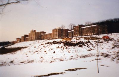
Dixmont State Hospital, Former psychiatric hospital in Kilbuck Township, United States.

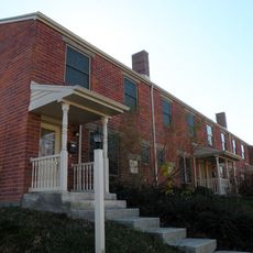
Dixmont State Hospital was a psychiatric facility northwest of Pittsburgh that occupied a sprawling self-contained campus with farmland, a private rail station, and independent utility systems. The grounds were designed to function as a largely self-sufficient community with separate buildings for different purposes and care levels.

The facility opened in 1862 by transferring patients from an earlier institution and gradually expanded significantly over its operating decades. This growth reflected increasing demand for psychiatric care and the era's confidence in treating mental illness through institutional settings.

The hospital served as a working community where patients participated in farming, gardening, and trades as part of their care. This approach shaped how people with mental illness were engaged in daily routines and reflected broader shifts in treatment philosophy.

The site is now abandoned and access is restricted for safety reasons, so exploring the grounds requires care and caution. Visitors interested in the history should check for organized tours or view the buildings from accessible public areas nearby.

The campus featured specialized buildings like Reed Hall designed with particular attention to ventilation systems and patient comfort standards of the era. These architectural choices reflected careful planning to support the medical practices and beliefs of that time period.

The community of curious travelers

AroundUs brings together thousands of curated places, local tips, and hidden gems, enriched daily by 60,000 contributors worldwide.

Start exploring
Location
Inception
1862
GPS coordinates
40.51583,-80.11222
Latest update
December 7, 2025 20:40
Around this place
Allegheny Observatory
United States of America

Allegheny Observatory

8.6 km
West View Park
United States of America

West View Park

6.6 km
Brunot Island
United States of America

Brunot Island

8.3 km
McKees Rocks Bridge
United States of America

McKees Rocks Bridge

6.9 km
Perry Traditional Academy
United States of America

Perry Traditional Academy

8.4 km
Langley High School
United States of America

Langley High School

8.4 km
Sewickley Bridge
United States of America

Sewickley Bridge

6.7 km
Wilpen Hall
United States of America

Wilpen Hall

4.9 km
Coraopolis Bridge
United States of America

Coraopolis Bridge

3.4 km
Neville Island Bridge
United States of America

Neville Island Bridge

1.9 km
Ohio Connecting Railroad Bridge
United States of America

Ohio Connecting Railroad Bridge

8.3 km
Emsworth Locks and Dam
United States of America

Emsworth Locks and Dam

2.4 km
Andrew Bayne Memorial Library
United States of America

Andrew Bayne Memorial Library

5.4 km
Davis Island Lock and Dam Site
United States of America

Davis Island Lock and Dam Site

4.7 km
John Morrow Elementary School
United States of America

John Morrow Elementary School

7.3 km
Fleming Park Bridge
United States of America

Fleming Park Bridge

3.9 km
Sewickley Public Library
United States of America

Sewickley Public Library

6.4 km
Nicholas Way House
United States of America

Nicholas Way House

7.4 km
Coraopolis Armory
United States of America

Coraopolis Armory

4.8 km
Mooncrest Historic District
United States of America

Mooncrest Historic District

6.7 km
PC&Y Railroad Bridge
United States of America

PC&Y Railroad Bridge

3.7 km
Davis Island
United States of America

Davis Island

4.5 km
899 Old Thorn Run Road
United States of America

899 Old Thorn Run Road

7.2 km
George J. Schmitt House
United States of America

George J. Schmitt House

2.6 km
United States Post Office-Sewickley Branch
United States of America

United States Post Office-Sewickley Branch

6.5 km
Arthurs-Johnson House
United States of America

Arthurs-Johnson House

3 km
Becky Thatcher
United States of America

Becky Thatcher

771 m
Team Pittsburgh Dekhockey
United States of America

Team Pittsburgh Dekhockey

6.8 km
Show the full map
Reviews
Share your experience

No review yet

Discussions
Start a discussion...

No discussion yet

« Dixmont State Hospital - Former psychiatric hospital in Kilbuck Township, United States » is provided by Around Us (aroundus.com). Images and texts are derived from Wikimedia project under a Creative Commons license. You are allowed to copy, distribute, and modify copies of this page, under the conditions set by the license, as long as this note is clearly visible.

Discover hidden gems everywhere you go!

From secret cafés to breathtaking viewpoints, skip the crowded tourist spots and find places that match your style. Our app makes it easy with voice search, smart filtering, route optimization, and insider tips from travelers worldwide. Download now for the complete mobile experience.

Around Us App Screenshot

A unique approach to discovering new places

Le Figaro

All the places worth exploring

France Info

A tailor-made excursion in just a few clicks

20 Minutes

Around Us
Travel Guide & Maps
Download

Send to your phone

QR Code
1

Open the camera app on your mobile.

2

Point at the QR code with your camera. A notification will appear.

3

Tap the notification to open the link.