Enable Location

We need your location to show you interesting places around you

Discover nearby places

Find interesting locations and hidden gems around you

Precise directions

Get accurate directions and distances to places

Your location is never shared with other users. It's only used when you tap the location button.

Log in to your account

Start exploring — it's free

Trusted by 63,087 travelers worldwide

Continue with Google
Continue with Apple
or

We will send you a code to connect

By continuing, you accept our Terms and Conditions and our Privacy Policy

Check your inbox

We've sent a pincode in your inbox. Please enter the code below.

Edward R. Madigan State Fish and Wildlife Area
Discussion Reviews Photo
1.8k Popularity

Edward R. Madigan State Fish and Wildlife Area, Conservation area in Logan County, United States

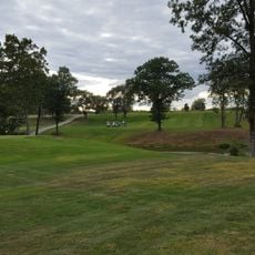
Edward R. Madigan State Fish and Wildlife Area is a conservation site in Logan County featuring mixed forests, open grasslands, and a winding creek that runs through the property. The land supports diverse wildlife and provides space for both recreation and natural habitat protection.

The site was established in 1971 as Railsplitter State Park and renamed in 1995 to honor Edward R. Madigan, a former United States Agriculture Secretary. This change reflected a desire to recognize his contributions to agricultural policy and conservation efforts.

The Illinois Department of Natural Resources manages this land to maintain a balance between recreational activities and wildlife preservation through sustainable practices.

The area welcomes hunting, fishing, hiking, and canoeing activities available throughout the year. Visitors should prepare for changing weather and follow local regulations while exploring the property.

This location operates a major pheasant production facility that raises thousands of birds each year for regional wildlife programs. The grounds also feature one of Illinois' largest American sycamore trees.

The community of curious travelers

AroundUs brings together thousands of curated places, local tips, and hidden gems, enriched daily by 60,000 contributors worldwide.

Start exploring
Location
Inception
1971
GPS coordinates
40.11670,-89.39170
Latest update
December 14, 2025 11:42
Around this place
Lincoln Tomb
United States of America

Lincoln Tomb

39.7 km
Camp Butler National Cemetery
United States of America

Camp Butler National Cemetery

34.5 km
Shea's Gas Station Museum
United States of America

Shea's Gas Station Museum

38.1 km
National Weather Service Lincoln, Illinois
United States of America

National Weather Service Lincoln, Illinois

6 km
Carpenter Park
United States of America

Carpenter Park

34.2 km
Mount Pulaski Courthouse State Historic Site
United States of America

Mount Pulaski Courthouse State Historic Site

15.1 km
Bolivia Road Bridge
United States of America

Bolivia Road Bridge

39.1 km
Lincoln Courthouse Square Historic District
United States of America

Lincoln Courthouse Square Historic District

4.2 km
University Hall
United States of America

University Hall

5.2 km
Atlanta Public Library
United States of America

Atlanta Public Library

20.3 km
J. H. Hawes Elevator
United States of America

J. H. Hawes Elevator

20.9 km
George M. Brinkerhoff House
United States of America

George M. Brinkerhoff House

39.5 km
North Sangamon United Presbyterian Church
United States of America

North Sangamon United Presbyterian Church

30.9 km
Price-Prather House
United States of America

Price-Prather House

22.3 km
Magill House
United States of America

Magill House

37 km
Waltmire Bridge
United States of America

Waltmire Bridge

38 km
Robert Buckles Barn
United States of America

Robert Buckles Barn

17.7 km
Lincoln Public Library
United States of America

Lincoln Public Library

4.3 km
Ayer Public Library
United States of America

Ayer Public Library

31.6 km
DeWitt County Courthouse
United States of America

DeWitt County Courthouse

36.8 km
Third Street Bridge
United States of America

Third Street Bridge

31.4 km
Hoblit House
United States of America

Hoblit House

4.8 km
Stephan A. Foley House
United States of America

Stephan A. Foley House

4.6 km
Theodore H. O. Mattfeldt House
United States of America

Theodore H. O. Mattfeldt House

15 km
Delavan Commercial Historic District
United States of America

Delavan Commercial Historic District

31.4 km
Lincoln Tomb State Historic Site
United States of America

Lincoln Tomb State Historic Site

39.8 km
Long Bridge Golf Course
United States of America

Long Bridge Golf Course

37.4 km
Lincoln Heritage Museum
United States of America

Lincoln Heritage Museum

5.4 km
Show the full map
Reviews
Share your experience

No review yet

Discussions
Start a discussion...

No discussion yet

« Edward R. Madigan State Fish and Wildlife Area - Conservation area in Logan County, United States » is provided by Around Us (aroundus.com). Images and texts are derived from Wikimedia project under a Creative Commons license. You are allowed to copy, distribute, and modify copies of this page, under the conditions set by the license, as long as this note is clearly visible.

Discover hidden gems everywhere you go!

From secret cafés to breathtaking viewpoints, skip the crowded tourist spots and find places that match your style. Our app makes it easy with voice search, smart filtering, route optimization, and insider tips from travelers worldwide. Download now for the complete mobile experience.

Around Us App Screenshot

A unique approach to discovering new places

Le Figaro

All the places worth exploring

France Info

A tailor-made excursion in just a few clicks

20 Minutes

Around Us
Travel Guide & Maps
Download

Send to your phone

QR Code
1

Open the camera app on your mobile.

2

Point at the QR code with your camera. A notification will appear.

3

Tap the notification to open the link.