Enable Location

We need your location to show you interesting places around you

Discover nearby places

Find interesting locations and hidden gems around you

Precise directions

Get accurate directions and distances to places

Your location is never shared with other users. It's only used when you tap the location button.

Bolivia Road Bridge

Log in to your account

Start exploring — it's free

Trusted by 62,173 travelers worldwide

Continue with Google
Continue with Apple
or

We will send you a code to connect

By continuing, you accept our Terms and Conditions and our Privacy Policy

Check your inbox

We've sent a pincode in your inbox. Please enter the code below.

Bolivia Road Bridge, Steel bridge in Mount Auburn Township, US

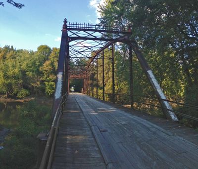
Bolivia Road Bridge is a steel truss bridge that spans the North Fork of the Sangamon River and connects Sangamon County with Christian County. The structure showcases the Parker through truss design, an engineering method commonly used in the early twentieth century for river crossings.

The structure was built in 1901 by J.T. Garrett from St. Louis and represents key engineering techniques of the early twentieth century. It remained in service for over a hundred years before operational concerns led to its closure.

The bridge takes its name from the former settlement of Bolivia, pronounced 'Bolivee' by local residents of central Illinois. That community moved southward when railroad expansion changed the region.

The bridge is currently closed to public traffic and not passable for vehicles. Visitors can view the structure from outside to appreciate its historical Parker truss engineering design.

A 1994 Department of Transportation survey identified this bridge as one of only seven remaining Parker through truss bridges in Illinois. Following a traffic accident in 2015, county officials made the permanent closure decision.

The community of curious travelers

AroundUs brings together thousands of curated places, local tips, and hidden gems, enriched daily by 60,000 contributors worldwide.

Start exploring
Inception
1901
GPS coordinates
39.76750,-89.34556
Latest update
December 14, 2025 16:42
Around this place
Abraham Lincoln Presidential Library and Museum
United States of America

Abraham Lincoln Presidential Library and Museum

26.1 km
Lincoln Home National Historic Site
United States of America

Lincoln Home National Historic Site

25.8 km
Illinois Governor's Mansion
United States of America

Illinois Governor's Mansion

26.2 km
Old State Capitol State Historic Site
United States of America

Old State Capitol State Historic Site

26.2 km
Camp Butler National Cemetery
United States of America

Camp Butler National Cemetery

19.6 km
Lincoln-Herndon Law Offices State Historic Site
United States of America

Lincoln-Herndon Law Offices State Historic Site

26.1 km
First Presbyterian Church
United States of America

First Presbyterian Church

26 km
Wyndham Springfield City Centre
United States of America

Wyndham Springfield City Centre

25.9 km
Shea's Gas Station Museum
United States of America

Shea's Gas Station Museum

25.9 km
Cathedral of the Immaculate Conception
United States of America

Cathedral of the Immaculate Conception

26.1 km
Abraham Lincoln Memorial Garden
United States of America

Abraham Lincoln Memorial Garden

22.9 km
Vachel Lindsay House
United States of America

Vachel Lindsay House

26.2 km
Elijah Iles House
United States of America

Elijah Iles House

25.9 km
Lincoln Colored Home
United States of America

Lincoln Colored Home

25.4 km
United States of America

Sangamon County Courthouse

25.7 km
Strawbridge-Shepherd House
United States of America

Strawbridge-Shepherd House

23.7 km
Illinois Department of Mines and Minerals-Springfield Mine Rescue Station
United States of America

Illinois Department of Mines and Minerals-Springfield Mine Rescue Station

25.9 km
Taylorville Chautauqua Auditorium
United States of America

Taylorville Chautauqua Auditorium

25.7 km
Virgil Hickox House
United States of America

Virgil Hickox House

26.1 km
Town House
United States of America

Town House

25.9 km
Robert Buckles Barn
United States of America

Robert Buckles Barn

25 km
Bressmer-Baker House
United States of America

Bressmer-Baker House

26 km
Taylorville Courthouse Square Historic District
United States of America

Taylorville Courthouse Square Historic District

24.8 km
Joseph Ross House
United States of America

Joseph Ross House

8.9 km
Cong. James M. Graham House
United States of America

Cong. James M. Graham House

26 km
Price/Wheeler House
United States of America

Price/Wheeler House

25.9 km
Taft Farmstead
United States of America

Taft Farmstead

18.4 km
Abraham Lincoln Museum Parking
United States of America

Abraham Lincoln Museum Parking

26.2 km
Show the full map
« Bolivia Road Bridge - Steel bridge in Mount Auburn Township, US » is provided by Around Us (aroundus.com). Images and texts are derived from Wikimedia project under a Creative Commons license. You are allowed to copy, distribute, and modify copies of this page, under the conditions set by the license, as long as this note is clearly visible.

Discover hidden gems everywhere you go!

From secret cafés to breathtaking viewpoints, skip the crowded tourist spots and find places that match your style. Our app makes it easy with voice search, smart filtering, route optimization, and insider tips from travelers worldwide. Download now for the complete mobile experience.

Around Us App Screenshot

A unique approach to discovering new places

Le Figaro

All the places worth exploring

France Info

A tailor-made excursion in just a few clicks

20 Minutes

Around Us
Travel Guide & Maps
Download

Send to your phone

QR Code
1

Open the camera app on your mobile.

2

Point at the QR code with your camera. A notification will appear.

3

Tap the notification to open the link.