Enable Location

We need your location to show you interesting places around you

Discover nearby places

Find interesting locations and hidden gems around you

Precise directions

Get accurate directions and distances to places

Your location is never shared with other users. It's only used when you tap the location button.

Elsing Green

Log in to your account

Start exploring — it's free

Trusted by 66,119 travelers worldwide

Continue with Google
Continue with Apple
or

We will send you a code to connect

By continuing, you accept our Terms and Conditions and our Privacy Policy

Check your inbox

We've sent a pincode in your inbox. Please enter the code below.

Discussion Reviews 1 Photos
3.8k Popularity

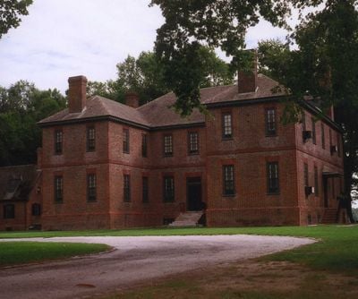
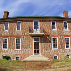
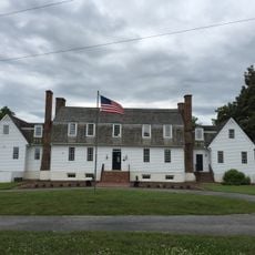
Elsing Green, National Historic Landmark plantation in King William County, Virginia.

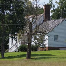
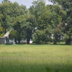
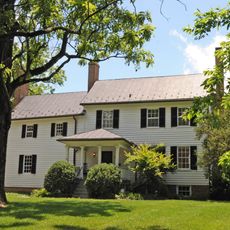
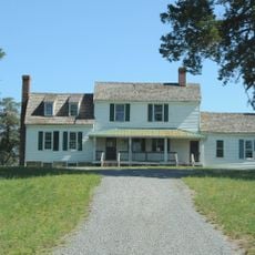
Elsing Green is a plantation in Virginia featuring a U-shaped brick manor house built in Flemish-bond brickwork, with east and west wings that face the Pamunkey River. The surrounding land includes working fields, woodlands, marshes, and swamps, and the estate remains an active farm to this day.

The site was first settled in the late 1600s by a colonial planter, and by the mid-1700s it passed to a statesman connected to the founding of the United States, who commissioned the brick manor house. Ownership then changed hands several more times before the estate reached its current form.

The rooms contain 18th-century American and English furnishings that reflect how wealthy planters lived and conducted business during that era. Some pieces have connections to pivotal national events that happened at this location.

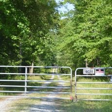
The estate is a working farm, so it is worth checking in advance whether visits are possible and when. Wear sturdy footwear, as the grounds cover fields, woodlands, and wetland areas.

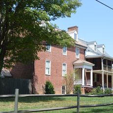
Behind the main manor house stands a brick structure from the original late-1600s settlement, now used as a dependency building within the same complex. This older section was not torn down when the new house was built but instead absorbed into it, making the two buildings readable as different chapters of the same story.

The community of curious travelers

AroundUs brings together thousands of curated places, local tips, and hidden gems, enriched daily by 60,000 contributors worldwide.

Start exploring
Location
GPS coordinates
37.60240,-77.05110
Latest update
March 3, 2026 14:03
Around this place
Edmund Ruffin Plantation
United States of America

Edmund Ruffin Plantation

16.2 km
Cold Harbor National Cemetery
United States of America

Cold Harbor National Cemetery

20.9 km
King William County Courthouse
United States of America

King William County Courthouse

10.1 km
Pamunkey Indian Tribe Museum
United States of America

Pamunkey Indian Tribe Museum

5.3 km
Chericoke
United States of America

Chericoke

6.6 km
United States of America

Immanuel Episcopal Church

15.3 km
Sweet Hall
United States of America

Sweet Hall

13.5 km
Chelsea
United States of America

Chelsea

19.6 km
King and Queen Courthouse Green Historic District
United States of America

King and Queen Courthouse Green Historic District

16.9 km
Emmaus Baptist Church
United States of America

Emmaus Baptist Church

12.1 km
Northbank
United States of America

Northbank

18.4 km
Windsor Shades
United States of America

Windsor Shades

13 km
Former New Kent High School
United States of America

Former New Kent High School

11.2 km
Olivet Presbyterian Church
United States of America

Olivet Presbyterian Church

13.7 km
Fort Mattapony
United States of America

Fort Mattapony

14.5 km
Newington Archaeological Site
United States of America

Newington Archaeological Site

15.2 km
Spring Hill (Providence Forge, Virginia)
United States of America

Spring Hill (Providence Forge, Virginia)

12.1 km
Cumberland
United States of America

Cumberland

9.5 km
Spring Green (Mechanicsville, Virginia)
United States of America

Spring Green (Mechanicsville, Virginia)

11.1 km
Clover Lea
United States of America

Clover Lea

12.7 km
Marl Hill
United States of America

Marl Hill

7 km
Mount Columbia
United States of America

Mount Columbia

17.3 km
Cedar Lane
United States of America

Cedar Lane

8.1 km
The Tavern at Old Church
United States of America

The Tavern at Old Church

15.7 km
Lanesville Christadelphian Church
United States of America

Lanesville Christadelphian Church

6.5 km
Royal New Kent Golf Club
United States of America

Royal New Kent Golf Club

14.6 km
Garthright House
United States of America

Garthright House

20.1 km
New Kent School and George W. Watkins School
United States of America

New Kent School and George W. Watkins School

11.2 km
Show the full map
Reviews
Share your experience

No review yet

Discussions
Start a discussion...

No discussion yet

« Elsing Green - National Historic Landmark plantation in King William County, Virginia » is provided by Around Us (aroundus.com). Images and texts are derived from Wikimedia project under a Creative Commons license. You are allowed to copy, distribute, and modify copies of this page, under the conditions set by the license, as long as this note is clearly visible.

Discover hidden gems everywhere you go!

From secret cafés to breathtaking viewpoints, skip the crowded tourist spots and find places that match your style. Our app makes it easy with voice search, smart filtering, route optimization, and insider tips from travelers worldwide. Download now for the complete mobile experience.

Around Us App Screenshot

A unique approach to discovering new places

Le Figaro

All the places worth exploring

France Info

A tailor-made excursion in just a few clicks

20 Minutes

Around Us
Travel Guide & Maps
Download

Send to your phone

QR Code
1

Open the camera app on your mobile.

2

Point at the QR code with your camera. A notification will appear.

3

Tap the notification to open the link.