Chest opened
+${chestReward.xp} XP
Explorer
NOUVEAU ×${chestReward.collectible.quantity}
tapez pour fermer
Chest locked

Open chests in the app

Around Us is built for your phone — chests unlock when you walk, explore and capture nearby places.

Enable Location

We need your location to show you interesting places around you

Discover nearby places

Find interesting locations and hidden gems around you

Precise directions

Get accurate directions and distances to places

Your location is never shared with other users. It's only used when you tap the location button.

Gimry

Log in to your account

Start exploring — it's free

Trusted by 72,878 travelers worldwide

Continue with Google
Continue with Apple
or

We will send you a code to connect

By continuing, you accept our Terms and Conditions and our Privacy Policy

Check your inbox

We've sent a pincode in your inbox. Please enter the code below.

Discussion Reviews 1 Photos
15.8k Popularity

Gimry, human settlement in Russia

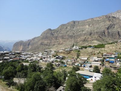
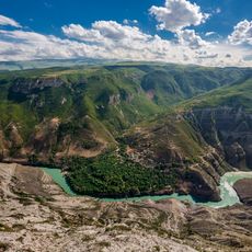
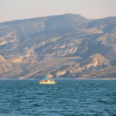
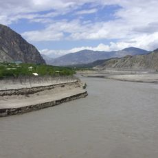
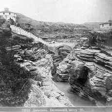
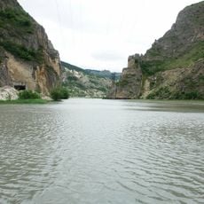
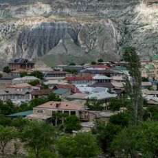
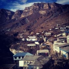
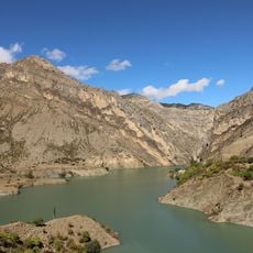
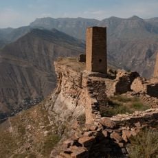
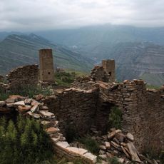
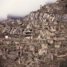
Gimry is a mountain village in the Russian republic of Dagestan, set on the east bank of the Avar Koysu river at the base of a deep canyon. Steep cliffs rise on all sides around the settlement, and the hillsides are lined with terraced gardens where fruit trees and vines grow.

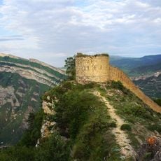
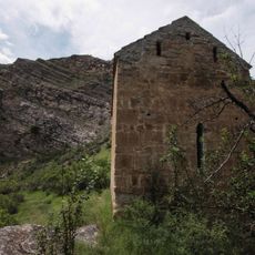
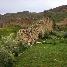
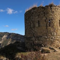
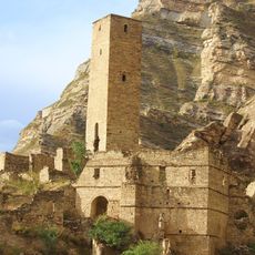
In the 19th century, Gimry became a focal point of resistance in the Caucasus, when highland communities built defensive structures throughout the area. The village is known as the birthplace of Shamil, the leader who organized armed resistance against Russian expansion in the region.

The name Gimry comes from the Avar language and refers to the canyon setting of the village. Visitors today can see how the terraced gardens on the hillsides are still actively farmed, shaping the rhythm of daily life here.

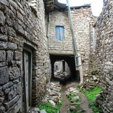
The village sits in a remote canyon and can only be reached by winding mountain roads, so the journey requires planning and enough time. Once there, the narrow streets are best explored on foot, as that is the only way to get close to the stone houses and terraced gardens.

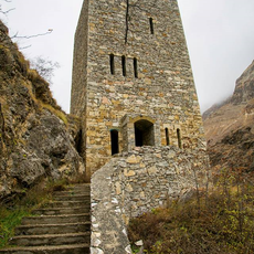
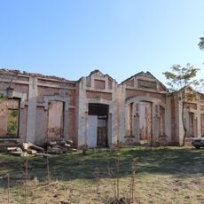
A bathhouse built by Sheikh Abdullah-haji Gimrinsky served for generations as one of the main places where men gathered to talk and spend time together. It is one of the few surviving examples of this type of communal building still found in the mountain villages of Dagestan.

The community of curious travelers

AroundUs brings together thousands of curated places, local tips, and hidden gems, enriched daily by 60,000 contributors worldwide.

Start exploring
Location
GPS coordinates
42.75778,46.84222
Latest update
March 3, 2026 10:14
Around this place
Sulak Canyon
Russian Federation

Sulak Canyon

28 km
Chirkey Dam
Russian Federation

Chirkey Dam

24.5 km
Gunib Fortress
Russian Federation

Gunib Fortress

41.9 km
Datuna Church
Russian Federation

Datuna Church

36.8 km
Chirkey Reservoir
Russian Federation

Chirkey Reservoir

23.5 km
Gimry tower
Russian Federation

Gimry tower

2.9 km
Irganai Reservoir
Russian Federation

Irganai Reservoir

10.3 km
Khunzakh Fortress
Russian Federation

Khunzakh Fortress

24.5 km
Евгеньевское укрепление
Russian Federation

Евгеньевское укрепление

22.3 km
Gergebil Reservoir
Russian Federation

Gergebil Reservoir

37.5 km
Yurd-Aux məscidi
Russian Federation

Yurd-Aux məscidi

41.3 km
Canta-Aukh
Russian Federation

Canta-Aukh

31.3 km
Мечеть (Салта)
Russian Federation

Мечеть (Салта)

44.4 km
Крепостная стена (Гуниб)
Russian Federation

Крепостная стена (Гуниб)

41.9 km
Селение Нижний Батлух (Нижний Батлух)
Russian Federation

Селение Нижний Батлух (Нижний Батлух)

39.9 km
Старинные мечети (Эндирей)
Russian Federation

Старинные мечети (Эндирей)

48 km
Водохранилище (Гуниб)
Russian Federation

Водохранилище (Гуниб)

39 km
Селение Корода (архитектурный комплекс) (Корода)
Russian Federation

Селение Корода (архитектурный комплекс) (Корода)

34.2 km
Оборонительная сторожевая башня (Гуниб)
Russian Federation

Оборонительная сторожевая башня (Гуниб)

41.7 km
Обелиск строителям дороги Порт-Петровск - Темир-Хан-Шура (Ленинкент)
Russian Federation

Обелиск строителям дороги Порт-Петровск - Темир-Хан-Шура (Ленинкент)

48 km
Верхняя боевая башня (Кахиб)
Russian Federation

Верхняя боевая башня (Кахиб)

41.3 km
Три Гоорские башни (Гоор)
Russian Federation

Три Гоорские башни (Гоор)

43 km
Селение «Гоор» (Гоор)
Russian Federation

Селение «Гоор» (Гоор)

43 km
Селение Кахиб (старое) (Кахиб)
Russian Federation

Селение Кахиб (старое) (Кахиб)

41.4 km
Здание вокзала на ж\д станции (Кумторкала)
Russian Federation

Здание вокзала на ж\д станции (Кумторкала)

42.3 km
Старинная мечеть (Эндирей)
Russian Federation

Старинная мечеть (Эндирей)

48 km
Museum in Buynaksk
Russian Federation

Museum in Buynaksk

23.5 km
Нижние ворота крепости (Гуниб)
Russian Federation

Нижние ворота крепости (Гуниб)

42.4 km
Show the full map
Reviews
Share your experience

No review yet

Discussions
Start a discussion...

No discussion yet

« Gimry - human settlement in Russia » is provided by Around Us (aroundus.com). Images and texts are derived from Wikimedia project under a Creative Commons license. You are allowed to copy, distribute, and modify copies of this page, under the conditions set by the license, as long as this note is clearly visible.

Discover hidden gems everywhere you go!

From secret cafés to breathtaking viewpoints, skip the crowded tourist spots and find places that match your style. Our app makes it easy with voice search, smart filtering, route optimization, and insider tips from travelers worldwide. Download now for the complete mobile experience.

Around Us App Screenshot

A unique approach to discovering new places

Le Figaro

All the places worth exploring

France Info

A tailor-made excursion in just a few clicks

20 Minutes

Around Us
Travel Guide & Maps
Download

Send to your phone

QR Code
1

Open the camera app on your mobile.

2

Point at the QR code with your camera. A notification will appear.

3

Tap the notification to open the link.