Impressive structures that turn barriers into crossings and places tourists want to visit.
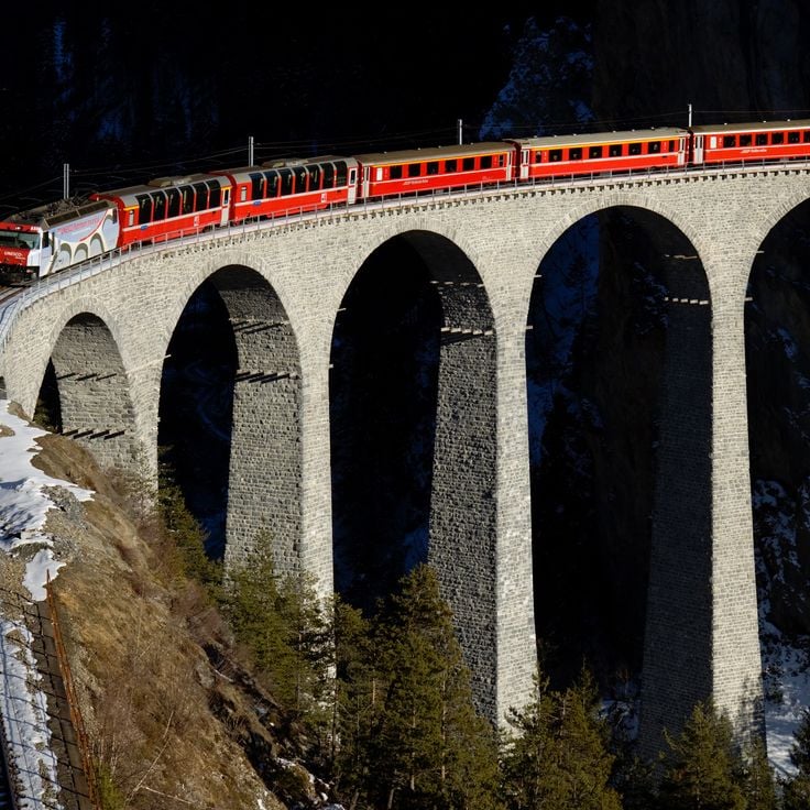
This collection brings together some of the most outstanding transport structures worldwide, representing engineering ingenuity and technical daring from various eras. From the Akashi Kaikyō Bridge of Japan, which holds the global record for span length at 1,991 meters (6,532 feet), to the Landwasser Viaduct in Switzerland, built in 1902 and opening directly into a mountain tunnel, each structure tells a story of overcoming geographical challenges.
These constructions connect areas separated by bays, straits, deep valleys, or waterways. The Hangzhou Bay Bridge in China stretches 36 kilometers (22 miles) across the waters of the East China Sea, while the Chesapeake Bay Bridge-Tunnel in the United States cleverly combines two modes of crossing over 37 kilometers (23 miles). In Scotland, the Forth Bridge has spanned the estuary since 1890 with its three distinctive steel cantilever spans, and in Bordeaux, the Jacques Chaban-Delmas Bridge stands out as Europe's tallest bascule bridge.
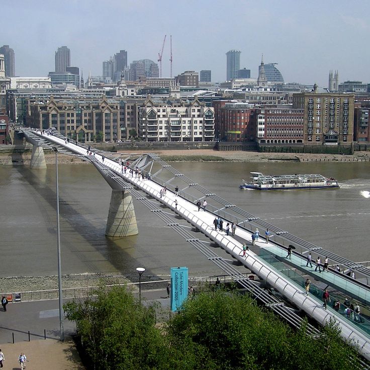
Beyond facilitating transport, these structures have become visual landmarks and destinations in their own right. The Royal Gorge Bridge in Colorado overlooks the Arkansas River by 955 feet (291 meters), while London's Millennium Bridge offers a direct pedestrian route between the Tate Modern and Saint Paul’s Cathedral. Each of these sites warrants a visit to appreciate the scope of technical achievement they embody.
Impressive structures that turn barriers into crossings and places tourists want to visit.
This collection brings together some of the most outstanding transport structures worldwide, representing engineering ingenuity and technical daring from various eras. From the Akashi Kaikyō Bridge of Japan, which holds the global record for span length at 1,991 meters (6,532 feet), to the Landwasser Viaduct in Switzerland, built in 1902 and opening directly into a mountain tunnel, each structure tells a story of overcoming geographical challenges.
These constructions connect areas separated by bays, straits, deep valleys, or waterways. The Hangzhou Bay Bridge in China stretches 36 kilometers (22 miles) across the waters of the East China Sea, while the Chesapeake Bay Bridge-Tunnel in the United States cleverly combines two modes of crossing over 37 kilometers (23 miles). In Scotland, the Forth Bridge has spanned the estuary since 1890 with its three distinctive steel cantilever spans, and in Bordeaux, the Jacques Chaban-Delmas Bridge stands out as Europe's tallest bascule bridge.
Beyond facilitating transport, these structures have become visual landmarks and destinations in their own right. The Royal Gorge Bridge in Colorado overlooks the Arkansas River by 955 feet (291 meters), while London's Millennium Bridge offers a direct pedestrian route between the Tate Modern and Saint Paul’s Cathedral. Each of these sites warrants a visit to appreciate the scope of technical achievement they embody.
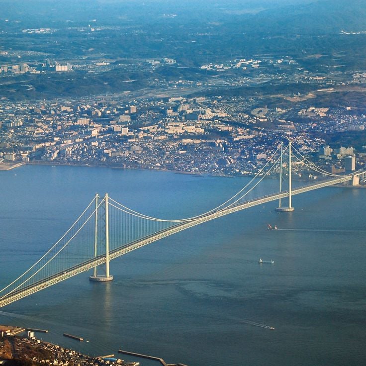
The Akashi Kaikyō Bridge in Japan holds the world record for the longest main span of any suspension bridge at 6,532 feet (1,991 meters), connecting the island of Honshū to Awaji Island and setting the benchmark for modern engineering since its opening in 1998. This massive structure crosses the Akashi Strait at a point known for strong tidal currents and frequent seismic activity, which demanded extraordinary technical solutions. The two 974-foot (297-meter) steel towers support cables tested under extreme conditions, as the Great Hanshin earthquake of 1995 occurred during construction and pushed the towers one meter further apart. The bridge serves as a critical transportation link within the Kansai region, providing a direct highway connection between Kobe and Shikoku Island via Awaji.
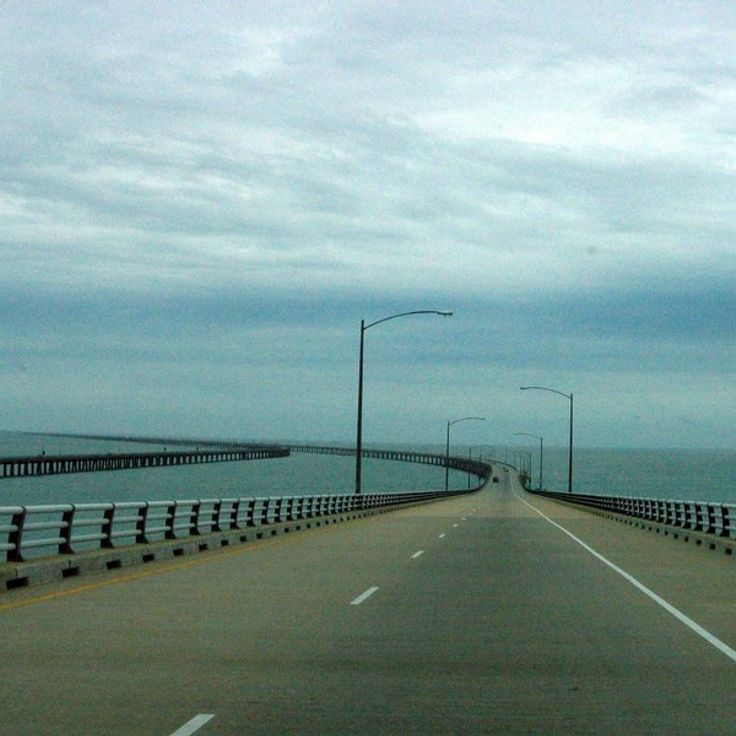
The Chesapeake Bay Bridge-Tunnel connects Virginia's Eastern Shore to the mainland across 23 miles (37 kilometers), combining two bridge sections with two underwater tunnels. This structure spans the mouth of Chesapeake Bay and allows ship passage through the submerged tunnel sections at strategic points. The construction opened in 1964 and was later expanded with a parallel roadway. The two artificial islands marking the transitions between bridges and tunnels serve as technical junction points of this engineering achievement. The crossing offers views of the largest estuary system in the United States and ranks among the most significant coastal transportation links on the American Atlantic coast.
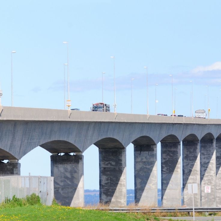
The Confederation Bridge opened in 1997, connecting Prince Edward Island to mainland Canada across the Northumberland Strait over a distance of 8 miles (13 kilometers). This bridge addresses the challenge of ice-covered waters through a design featuring 44 main piers engineered to withstand the pressure of ice floes. The structure accounts for extreme winter conditions, when ice reaches thicknesses up to 6.6 feet (2 meters). Before this connection was built, the island relied exclusively on ferry or air travel, which transformed the transportation situation fundamentally. The bridge rises 197 feet (60 meters) above water level to accommodate shipping traffic, and its curved alignment follows the natural geography of the strait.
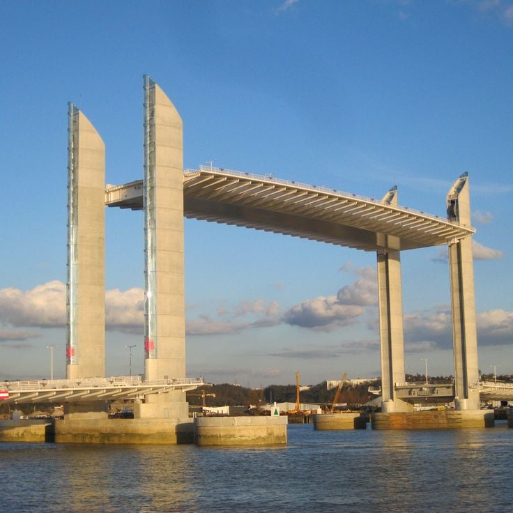
The Pont Jacques Chaban-Delmas was inaugurated in 2013 across the Garonne River in Bordeaux and stands as Europe's tallest vertical lift bridge, with four pylons rising 77 meters (253 feet) each. The bridge extends 575 meters (1,886 feet) in total length and features a 117-meter (384-foot) central span that can be raised vertically to allow larger vessels to pass through. This lifting mechanism achieves a clearance of 53 meters (174 feet) above water level, accommodating cruise ships traveling to the port area. The bridge connects the Bacalan-Bastide riverbanks with the historic center and forms part of the urban renewal project for the port districts. The cable-stayed design and clean lines of the structure reflect contemporary civil engineering and have made it a new landmark for the city.
This steel structure spans the Firth of Forth with three distinctive cantilever sections resting on massive stone piers. The Forth Bridge was completed in 1890 as a response to the collapse of the Tay Bridge years earlier, prompting engineers to develop a particularly robust design. The three main spans each reach approximately 1,700 feet (520 meters) and form a continuous railway connection between Edinburgh and the northern regions of Scotland. The red color of the more than 50,000 tons of steel is maintained through ongoing preservation work that has become symbolic of perpetual maintenance. This bridge remains a functioning example of Victorian engineering and carries dozens of trains daily across the estuary.
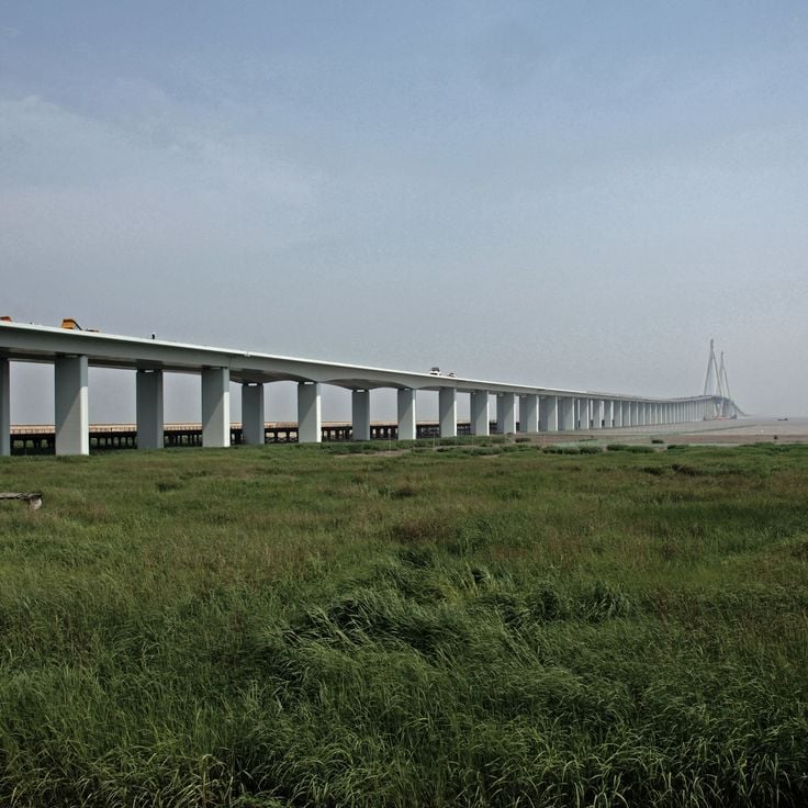
This six-lane highway bridge extends 36 kilometers (22 miles) across Hangzhou Bay, connecting the economic hub of Shanghai with the port city of Ningbo in Zhejiang Province. The construction consists of multiple continuous truss girder segments resting on over 5,000 pillars, allowing maritime traffic to pass beneath the roadway. Operational since 2008, the crossing reduces travel time between the two cities by several hours compared to the land-based route and contributes to the economic integration of the entire Yangtze Delta region. The design accounts for typhoon risks, tidal movements and seismic requirements in this geologically active coastal zone.
The Viaduc de Landwasser was completed in 1902 and carries the Albula Railway line across the Landwasser Valley in Graubünden. This six-arch limestone bridge rises 213 feet (65 meters) above the valley floor and spans 446 feet (136 meters). The structure leads directly into the Landwasser Tunnel, carved into the rock face – an engineering solution dictated by the confined space at this challenging section of track. The viaduct forms part of the UNESCO World Heritage Rhaetian Railway route and demonstrates the technical skill required to enable rail crossings through the Alps.
The Millennium Bridge spans the Thames as a pedestrian crossing made of steel and aluminum, linking the Tate Modern on the south bank with St. Paul's Cathedral on the north. Opened in 2000, this structure features a low-profile suspension design with two shore-based towers supporting the 325-meter (1,066-foot) span through lateral cables. The engineering approach allows clear sightlines across the river and the surrounding cityscape, while the structure forms part of those transport works that make London one of Europe's most accessible urban centers. The bridge was briefly closed after its opening to correct an unexpected lateral swaying problem, and today serves as an essential pedestrian link between two major cultural landmarks in the British capital.
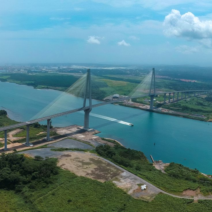
This two-lane reinforced concrete bridge over the Panama Canal has connected the east and west sides of Panama City since 1962, carrying approximately 35,000 vehicles daily. The Bridge of the Americas spans the Pacific entrance to the canal with a total length of 1654 meters (5425 feet) and reaches a clearance of 61 meters (201 feet) above the waterline to allow passage for even the largest vessels. Its construction marked a turning point in regional development, establishing for the first time a direct land connection between North and South America along the Pan-American Highway. This crossing fits within the collection of major transport structures that overcome geographical obstacles and link separated territories.
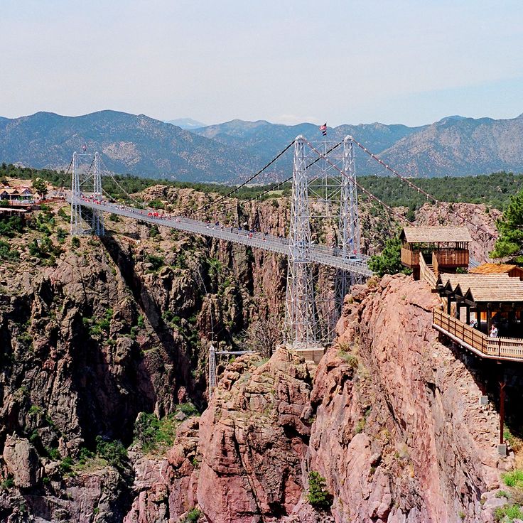
The Royal Gorge Bridge spans 1,260 feet across the Arkansas River at a height of 955 feet (291 meters), ranking among the world's highest bridges. This 1929 suspension bridge, built with wooden planks and steel cables, was constructed as a tourist attraction over the deep canyon of the Royal Gorge. The crossing provides a direct view of the river that carved through the rock below and allows visitors to grasp the scale of the geological cut while traversing the structure.
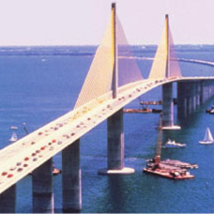
The Sunshine Skyway connects St. Petersburg to Terra Ceia across Tampa Bay, spanning 4.2 miles (6.7 kilometers). Opened in 1987, this concrete structure replaced an earlier bridge partially destroyed by a ship collision in 1980. Its most distinctive feature is the central cable-stayed section with two yellow pylons rising 431 feet (131 meters) above the water, supporting a main span of 1,200 feet (366 meters). The clearance of 180 feet (55 meters) allows large vessels to pass into Tampa Harbor. The remaining sections consist of low-level viaducts extending across the bay. For those exploring this collection, the Sunshine Skyway demonstrates how modern engineering responded to catastrophe by creating a safer and more efficient crossing.
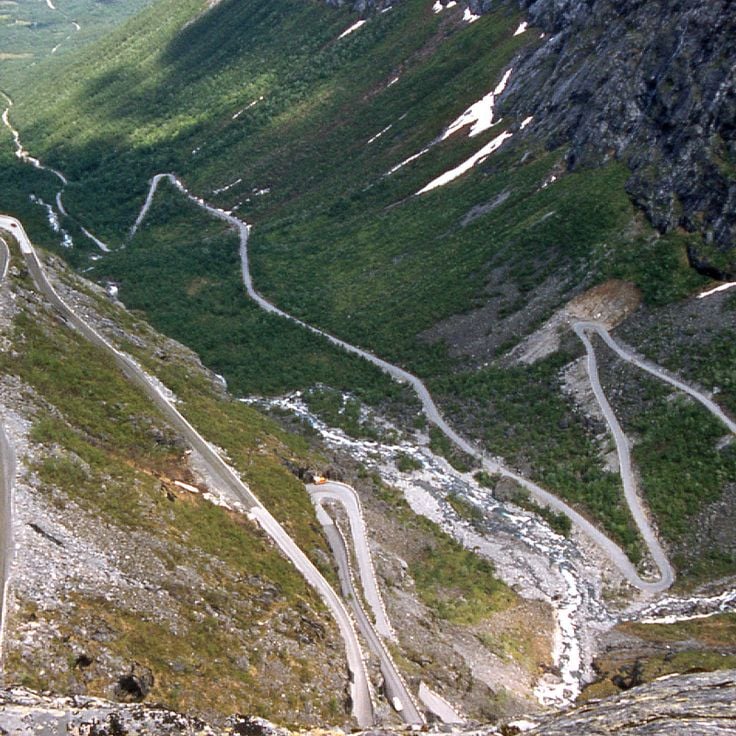
The Trollstigen mountain road traverses the Rauma region with eleven hairpin turns and an average gradient of 10 percent. Opened in 1936, this serpentine route connects the valley of Åndalsnes with the high plateau, ascending roughly 2800 feet (850 meters) over just 6 miles (9 kilometers). The construction follows the mountain walls through a landscape of sharp peaks, waterfalls and deep gorges. At the highest point, an observation platform provides views of the road layout and surrounding mountains. The route forms part of Norway's National Tourist Route system and demonstrates how engineers in the 1930s created access to remote regions. Trollstigen remains open between May and October and ranks among the most technically demanding mountain roads in Scandinavia.
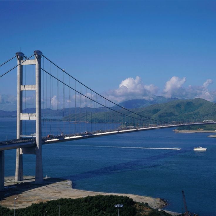
The Tsing Ma Bridge has linked central Hong Kong with the international airport on Lantau Island across the Ma Wan Channel since 1997. This two-level steel suspension bridge features a main span of 4518 feet (1377 meters), ranking among the longest suspension bridges worldwide designed for combined road and rail traffic. The upper deck carries six highway lanes, while the sheltered lower deck accommodates two railway tracks for the Airport Express Line plus two additional lanes reserved for emergency use. The bridge towers rise 676 feet (206 meters) above sea level. During typhoons or severe weather, road traffic can be diverted to the protected lower deck. Construction required approximately 50000 tons of steel for the entire structure. Together with the nearby Kap Shui Mun Bridge, the Tsing Ma Bridge forms a critical transportation corridor within this collection of engineering projects that showcase technical solutions to complex geographic challenges.
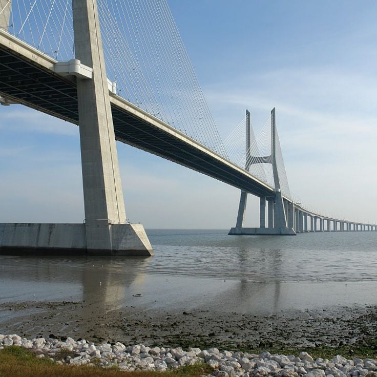
The Vasco da Gama Bridge is a six-lane highway crossing the Tagus River that connects Portugal's northern and southern regions and stood as Europe's longest bridge when completed in 1998. The structure extends 11 miles (17 kilometers) and was built to relieve traffic congestion on the overloaded Ponte 25 de Abril. The construction includes cable-stayed sections, viaducts, and a low-lying portion that allows large vessels to pass through. This transport connection demonstrates Portuguese engineering capability in the late 20th century and significantly improves mobility between Lisbon and the southern parts of the country.
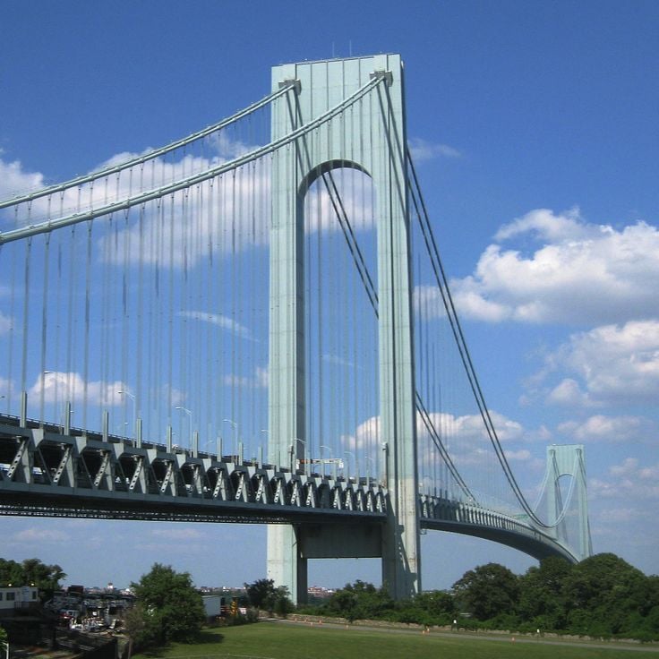
The Verrazzano-Narrows Bridge has connected Staten Island and Brooklyn since 1964, spanning The Narrows strait that links New York Harbor to the Atlantic Ocean. With a main span of 4,260 feet (1,298 meters), it held the title of longest suspension bridge in the world at its opening, a distinction it retained until 1981. The double-deck structure carries thirteen lanes of Interstate 278 across the water, with the upper level handling traffic to Staten Island and the lower level directing traffic to Brooklyn. The two towers rise 690 feet (210 meters) above mean high water and support the main cables, each composed of more than 26,000 individual wires. Construction required accounting for the Earth's curvature: the towers' tops are 1.6 inches (41 millimeters) farther apart than their bases due to the planet's spherical shape. The bridge serves as the starting point for the New York City Marathon and carries approximately 200,000 vehicles daily.
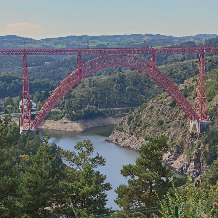
The Garabit Viaduct stands among the significant railway bridges of late 19th century French engineering. This steel structure was designed by Gustave Eiffel in 1884 and spans the Truyère valley at a height of 122 meters (400 feet). The bridge extends 565 meters (1,854 feet) and features a central arch with a span of 165 meters (541 feet) resting on stone piers. The delicate steel architecture demonstrates Eiffel's characteristic design approach three years before the construction of his famous Parisian tower. The viaduct continues to serve railway traffic between Béziers and Neussargues and represents the technical solutions developed to access the rugged landscape of Auvergne.
The West Gate Bridge crosses the Yarra River in Melbourne with eight traffic lanes over a total length of 1.5 miles (2.5 kilometers), connecting the western suburbs to the city center. This road bridge opened in 1978 and handles more than 200,000 vehicles daily, making it one of the busiest bridges in Australia. The main span of 1,102 feet (336 meters) made it the longest prestressed concrete box girder bridge in the country at completion. Construction was marked by the collapse of a section in 1970 that killed 35 workers. The bridge today forms an essential part of the West Gate Freeway and provides a critical transport link across the Melbourne metropolitan area.
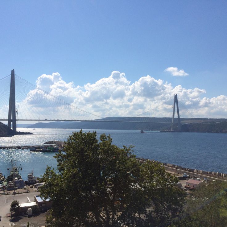
The Yavuz Sultan Selim Bridge links the European and Asian sides of Istanbul with eight highway lanes and two railway tracks. Completed in 2016, this structure spans 1408 meters (4619 feet) across the Bosphorus, making it one of the longest combined road and rail suspension bridges in the world. Located approximately 25 miles (40 kilometers) north of the city center, the bridge relieves congestion on Istanbul's two older Bosphorus crossings. Its deck sits on two 1056-foot (322-meter) pylons and provides continuous connection between the motorways on both continents as well as the railway lines that link European and Asian rail networks.
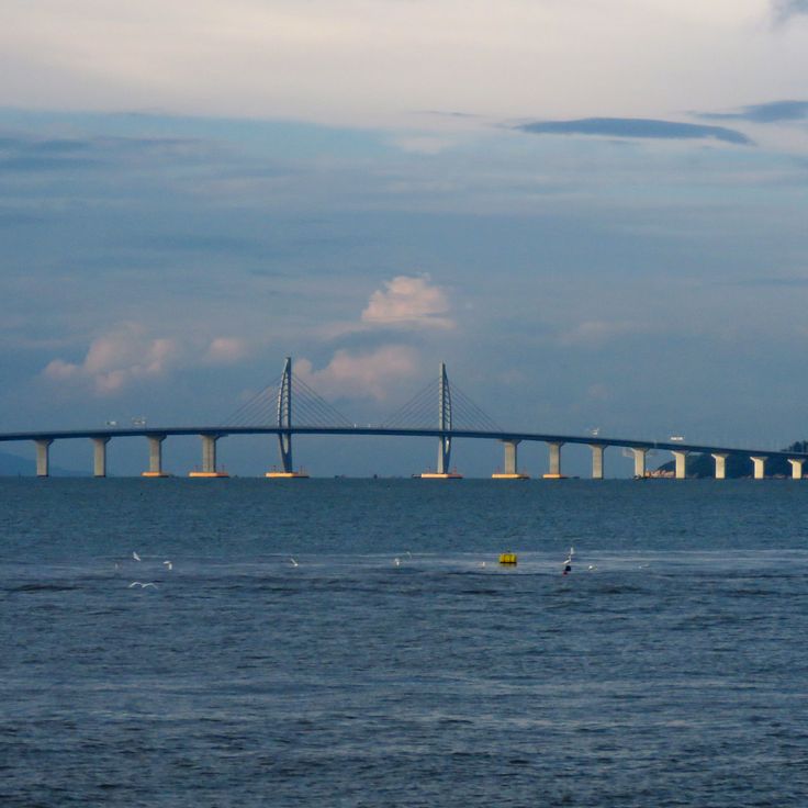
The Zhuhai, Macao, and Hong Kong Bridge system extends 34 miles (55 kilometers) across the Pearl River Delta, connecting three major cities through a combination of bridges and tunnels. Opened in 2018, the structure crosses the estuary waters and reduces travel time between Hong Kong and Zhuhai to approximately 45 minutes. The construction includes an underwater tunnel measuring 4.2 miles (6.7 kilometers) that allows maritime traffic to pass unobstructed, along with several bridge sections featuring pylons reaching heights of 535 feet (163 meters). This project ranks among the most technically demanding infrastructure undertakings of recent decades and demonstrates the resolution of complex logistical and engineering challenges in a heavily trafficked maritime area.
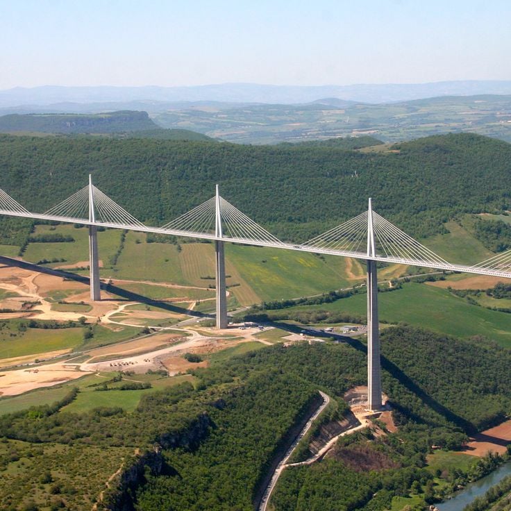
This cable-stayed viaduct spans the Tarn River gorge in the southern Massif Central with seven steel pylons rising up to 343 meters (1,125 feet), taller than the Eiffel Tower. Opened in 2004, the structure extends 2,460 meters (8,070 feet) and connects the Causse Rouge plateau with the Causse du Larzac on the A75 motorway between Paris and Béziers. The roadway sits 270 meters (886 feet) above the Tarn riverbed, and the design with its gently curved pylons represents a significant civil engineering achievement of the 21st century. Visitors can observe the scale of the construction from the adjacent visitor center or experience the structure while crossing it.
The Akashi Kaikyō Bridge in Japan holds the world record for the longest main span of any suspension bridge at 6,532 feet (1,991 meters), connecting the island of Honshū to Awaji Island and setting the benchmark for modern engineering since its opening in 1998. This massive structure crosses the Akashi Strait at a point known for strong tidal currents and frequent seismic activity, which demanded extraordinary technical solutions. The two 974-foot (297-meter) steel towers support cables tested under extreme conditions, as the Great Hanshin earthquake of 1995 occurred during construction and pushed the towers one meter further apart. The bridge serves as a critical transportation link within the Kansai region, providing a direct highway connection between Kobe and Shikoku Island via Awaji.
The Chesapeake Bay Bridge-Tunnel connects Virginia's Eastern Shore to the mainland across 23 miles (37 kilometers), combining two bridge sections with two underwater tunnels. This structure spans the mouth of Chesapeake Bay and allows ship passage through the submerged tunnel sections at strategic points. The construction opened in 1964 and was later expanded with a parallel roadway. The two artificial islands marking the transitions between bridges and tunnels serve as technical junction points of this engineering achievement. The crossing offers views of the largest estuary system in the United States and ranks among the most significant coastal transportation links on the American Atlantic coast.
The Confederation Bridge opened in 1997, connecting Prince Edward Island to mainland Canada across the Northumberland Strait over a distance of 8 miles (13 kilometers). This bridge addresses the challenge of ice-covered waters through a design featuring 44 main piers engineered to withstand the pressure of ice floes. The structure accounts for extreme winter conditions, when ice reaches thicknesses up to 6.6 feet (2 meters). Before this connection was built, the island relied exclusively on ferry or air travel, which transformed the transportation situation fundamentally. The bridge rises 197 feet (60 meters) above water level to accommodate shipping traffic, and its curved alignment follows the natural geography of the strait.
The Pont Jacques Chaban-Delmas was inaugurated in 2013 across the Garonne River in Bordeaux and stands as Europe's tallest vertical lift bridge, with four pylons rising 77 meters (253 feet) each. The bridge extends 575 meters (1,886 feet) in total length and features a 117-meter (384-foot) central span that can be raised vertically to allow larger vessels to pass through. This lifting mechanism achieves a clearance of 53 meters (174 feet) above water level, accommodating cruise ships traveling to the port area. The bridge connects the Bacalan-Bastide riverbanks with the historic center and forms part of the urban renewal project for the port districts. The cable-stayed design and clean lines of the structure reflect contemporary civil engineering and have made it a new landmark for the city.
This steel structure spans the Firth of Forth with three distinctive cantilever sections resting on massive stone piers. The Forth Bridge was completed in 1890 as a response to the collapse of the Tay Bridge years earlier, prompting engineers to develop a particularly robust design. The three main spans each reach approximately 1,700 feet (520 meters) and form a continuous railway connection between Edinburgh and the northern regions of Scotland. The red color of the more than 50,000 tons of steel is maintained through ongoing preservation work that has become symbolic of perpetual maintenance. This bridge remains a functioning example of Victorian engineering and carries dozens of trains daily across the estuary.
This six-lane highway bridge extends 36 kilometers (22 miles) across Hangzhou Bay, connecting the economic hub of Shanghai with the port city of Ningbo in Zhejiang Province. The construction consists of multiple continuous truss girder segments resting on over 5,000 pillars, allowing maritime traffic to pass beneath the roadway. Operational since 2008, the crossing reduces travel time between the two cities by several hours compared to the land-based route and contributes to the economic integration of the entire Yangtze Delta region. The design accounts for typhoon risks, tidal movements and seismic requirements in this geologically active coastal zone.
The Viaduc de Landwasser was completed in 1902 and carries the Albula Railway line across the Landwasser Valley in Graubünden. This six-arch limestone bridge rises 213 feet (65 meters) above the valley floor and spans 446 feet (136 meters). The structure leads directly into the Landwasser Tunnel, carved into the rock face – an engineering solution dictated by the confined space at this challenging section of track. The viaduct forms part of the UNESCO World Heritage Rhaetian Railway route and demonstrates the technical skill required to enable rail crossings through the Alps.
The Millennium Bridge spans the Thames as a pedestrian crossing made of steel and aluminum, linking the Tate Modern on the south bank with St. Paul's Cathedral on the north. Opened in 2000, this structure features a low-profile suspension design with two shore-based towers supporting the 325-meter (1,066-foot) span through lateral cables. The engineering approach allows clear sightlines across the river and the surrounding cityscape, while the structure forms part of those transport works that make London one of Europe's most accessible urban centers. The bridge was briefly closed after its opening to correct an unexpected lateral swaying problem, and today serves as an essential pedestrian link between two major cultural landmarks in the British capital.
This two-lane reinforced concrete bridge over the Panama Canal has connected the east and west sides of Panama City since 1962, carrying approximately 35,000 vehicles daily. The Bridge of the Americas spans the Pacific entrance to the canal with a total length of 1654 meters (5425 feet) and reaches a clearance of 61 meters (201 feet) above the waterline to allow passage for even the largest vessels. Its construction marked a turning point in regional development, establishing for the first time a direct land connection between North and South America along the Pan-American Highway. This crossing fits within the collection of major transport structures that overcome geographical obstacles and link separated territories.
The Royal Gorge Bridge spans 1,260 feet across the Arkansas River at a height of 955 feet (291 meters), ranking among the world's highest bridges. This 1929 suspension bridge, built with wooden planks and steel cables, was constructed as a tourist attraction over the deep canyon of the Royal Gorge. The crossing provides a direct view of the river that carved through the rock below and allows visitors to grasp the scale of the geological cut while traversing the structure.
The Sunshine Skyway connects St. Petersburg to Terra Ceia across Tampa Bay, spanning 4.2 miles (6.7 kilometers). Opened in 1987, this concrete structure replaced an earlier bridge partially destroyed by a ship collision in 1980. Its most distinctive feature is the central cable-stayed section with two yellow pylons rising 431 feet (131 meters) above the water, supporting a main span of 1,200 feet (366 meters). The clearance of 180 feet (55 meters) allows large vessels to pass into Tampa Harbor. The remaining sections consist of low-level viaducts extending across the bay. For those exploring this collection, the Sunshine Skyway demonstrates how modern engineering responded to catastrophe by creating a safer and more efficient crossing.
The Trollstigen mountain road traverses the Rauma region with eleven hairpin turns and an average gradient of 10 percent. Opened in 1936, this serpentine route connects the valley of Åndalsnes with the high plateau, ascending roughly 2800 feet (850 meters) over just 6 miles (9 kilometers). The construction follows the mountain walls through a landscape of sharp peaks, waterfalls and deep gorges. At the highest point, an observation platform provides views of the road layout and surrounding mountains. The route forms part of Norway's National Tourist Route system and demonstrates how engineers in the 1930s created access to remote regions. Trollstigen remains open between May and October and ranks among the most technically demanding mountain roads in Scandinavia.
The Tsing Ma Bridge has linked central Hong Kong with the international airport on Lantau Island across the Ma Wan Channel since 1997. This two-level steel suspension bridge features a main span of 4518 feet (1377 meters), ranking among the longest suspension bridges worldwide designed for combined road and rail traffic. The upper deck carries six highway lanes, while the sheltered lower deck accommodates two railway tracks for the Airport Express Line plus two additional lanes reserved for emergency use. The bridge towers rise 676 feet (206 meters) above sea level. During typhoons or severe weather, road traffic can be diverted to the protected lower deck. Construction required approximately 50000 tons of steel for the entire structure. Together with the nearby Kap Shui Mun Bridge, the Tsing Ma Bridge forms a critical transportation corridor within this collection of engineering projects that showcase technical solutions to complex geographic challenges.
The Vasco da Gama Bridge is a six-lane highway crossing the Tagus River that connects Portugal's northern and southern regions and stood as Europe's longest bridge when completed in 1998. The structure extends 11 miles (17 kilometers) and was built to relieve traffic congestion on the overloaded Ponte 25 de Abril. The construction includes cable-stayed sections, viaducts, and a low-lying portion that allows large vessels to pass through. This transport connection demonstrates Portuguese engineering capability in the late 20th century and significantly improves mobility between Lisbon and the southern parts of the country.
The Verrazzano-Narrows Bridge has connected Staten Island and Brooklyn since 1964, spanning The Narrows strait that links New York Harbor to the Atlantic Ocean. With a main span of 4,260 feet (1,298 meters), it held the title of longest suspension bridge in the world at its opening, a distinction it retained until 1981. The double-deck structure carries thirteen lanes of Interstate 278 across the water, with the upper level handling traffic to Staten Island and the lower level directing traffic to Brooklyn. The two towers rise 690 feet (210 meters) above mean high water and support the main cables, each composed of more than 26,000 individual wires. Construction required accounting for the Earth's curvature: the towers' tops are 1.6 inches (41 millimeters) farther apart than their bases due to the planet's spherical shape. The bridge serves as the starting point for the New York City Marathon and carries approximately 200,000 vehicles daily.
The Garabit Viaduct stands among the significant railway bridges of late 19th century French engineering. This steel structure was designed by Gustave Eiffel in 1884 and spans the Truyère valley at a height of 122 meters (400 feet). The bridge extends 565 meters (1,854 feet) and features a central arch with a span of 165 meters (541 feet) resting on stone piers. The delicate steel architecture demonstrates Eiffel's characteristic design approach three years before the construction of his famous Parisian tower. The viaduct continues to serve railway traffic between Béziers and Neussargues and represents the technical solutions developed to access the rugged landscape of Auvergne.
The West Gate Bridge crosses the Yarra River in Melbourne with eight traffic lanes over a total length of 1.5 miles (2.5 kilometers), connecting the western suburbs to the city center. This road bridge opened in 1978 and handles more than 200,000 vehicles daily, making it one of the busiest bridges in Australia. The main span of 1,102 feet (336 meters) made it the longest prestressed concrete box girder bridge in the country at completion. Construction was marked by the collapse of a section in 1970 that killed 35 workers. The bridge today forms an essential part of the West Gate Freeway and provides a critical transport link across the Melbourne metropolitan area.
The Yavuz Sultan Selim Bridge links the European and Asian sides of Istanbul with eight highway lanes and two railway tracks. Completed in 2016, this structure spans 1408 meters (4619 feet) across the Bosphorus, making it one of the longest combined road and rail suspension bridges in the world. Located approximately 25 miles (40 kilometers) north of the city center, the bridge relieves congestion on Istanbul's two older Bosphorus crossings. Its deck sits on two 1056-foot (322-meter) pylons and provides continuous connection between the motorways on both continents as well as the railway lines that link European and Asian rail networks.
The Zhuhai, Macao, and Hong Kong Bridge system extends 34 miles (55 kilometers) across the Pearl River Delta, connecting three major cities through a combination of bridges and tunnels. Opened in 2018, the structure crosses the estuary waters and reduces travel time between Hong Kong and Zhuhai to approximately 45 minutes. The construction includes an underwater tunnel measuring 4.2 miles (6.7 kilometers) that allows maritime traffic to pass unobstructed, along with several bridge sections featuring pylons reaching heights of 535 feet (163 meters). This project ranks among the most technically demanding infrastructure undertakings of recent decades and demonstrates the resolution of complex logistical and engineering challenges in a heavily trafficked maritime area.
This cable-stayed viaduct spans the Tarn River gorge in the southern Massif Central with seven steel pylons rising up to 343 meters (1,125 feet), taller than the Eiffel Tower. Opened in 2004, the structure extends 2,460 meters (8,070 feet) and connects the Causse Rouge plateau with the Causse du Larzac on the A75 motorway between Paris and Béziers. The roadway sits 270 meters (886 feet) above the Tarn riverbed, and the design with its gently curved pylons represents a significant civil engineering achievement of the 21st century. Visitors can observe the scale of the construction from the adjacent visitor center or experience the structure while crossing it.
Visiting these structures helps to see how engineers solved difficult geographic problems. Some sites have free or low-cost viewing spots. Plan your visit based on the season: some mountain bridges are closed in winter.