Brown County

Log in to your account

AroundUs is a community-driven map of interesting places, built by curious explorers like you. It grows with every review, story, and photo you share.
Connect to save your favorite spots, contribute locations, and create personalized routes.
Continue with Google
Continue with Apple
Continue with X
Continue with Facebook
Continue with email
By continuing, you accept our Terms and Conditions and our Privacy Policy
Create an account
Add to collection
Map
Suggest a change
Share

Brown County, Administrative county near Cincinnati, United States

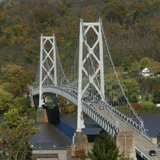
Brown County stretches along the Ohio River with Georgetown serving as its county seat and encompassing ten separate municipalities. The landscape consists mainly of rolling farmland and lies just inland from the Cincinnati area.

The county was established on December 27, 1817, from portions of Adams and Clermont counties, named after Jacob Brown, a military leader during the War of 1812. The region developed as an agricultural hub with growing importance tied to river commerce.

The Rankin House in Ripley operated as a critical stop on the Underground Railroad, helping people escape slavery by crossing into Kentucky across the river. Visitors today can explore the home and learn how local families risked their safety to assist those fleeing bondage.

The Brown County Common Pleas Court is located in Georgetown and handles court matters for the area. Most locations in the county are accessible by car, with roads connecting the different towns throughout the region.

The county produces a wide range of specialized industrial goods, from surgical instruments to plastic machinery parts and cement blocks. This diverse manufacturing base exists alongside the region's long agricultural tradition.

Location: Ohio

Inception: March 1, 1818

Capital city: Georgetown

Reference: BRO

Part of: Cincinnati metropolitan area

Shares border with: Clermont County, Clinton County, Highland County, Adams County, Mason County, Bracken County

Website: http://browncountyohio.gov

GPS coordinates: 38.93000,-83.87000

Latest update: December 23, 2025 15:22

Photos
Around this place
John Brett Richeson House
United States of America

John Brett Richeson House

32.7 km
John Rankin House
United States of America

John Rankin House

20.1 km
Simon Kenton Memorial Bridge
United States of America

Simon Kenton Memorial Bridge

32.6 km
Grant Boyhood Home
United States of America

Grant Boyhood Home

7.6 km
Phillips' Folly
United States of America

Phillips' Folly

32.7 km
William H. Harsha Bridge
United States of America

William H. Harsha Bridge

28.4 km
Rosemary Clooney Museum
United States of America

Rosemary Clooney Museum

21 km
John P. Parker House
United States of America

John P. Parker House

20.1 km
Brown County Courthouse
United States of America

Brown County Courthouse

7.8 km
Russell Theatre
United States of America

Russell Theatre

32.8 km
Lynchburg Covered Bridge
United States of America

Lynchburg Covered Bridge

35.7 km
Washington Opera House
United States of America

Washington Opera House

32.6 km
Confederate Monument in Augusta
United States of America

Confederate Monument in Augusta

21.7 km
Lee's Creek Covered Bridge
United States of America

Lee's Creek Covered Bridge

20.1 km
Cox Building
United States of America

Cox Building

32.8 km
Lee House
United States of America

Lee House

32.6 km
North Pole Road Covered Bridge
United States of America

North Pole Road Covered Bridge

21.7 km
Bracken Baptist Church
United States of America

Bracken Baptist Church

25.3 km
Newdigate-Reed House
United States of America

Newdigate-Reed House

32.7 km
Cox-Hord House
United States of America

Cox-Hord House

33.1 km
Pogue House
United States of America

Pogue House

30.9 km
Pisgah Christian Church
United States of America

Pisgah Christian Church

16.4 km
McCafferty Road Covered Bridge
United States of America

McCafferty Road Covered Bridge

26.9 km
Aberdeen Mound
United States of America

Aberdeen Mound

30.6 km
Point Au View
United States of America

Point Au View

32.3 km
Old Library Building
United States of America

Old Library Building

32.6 km
Eagle Creek Covered Bridge
United States of America

Eagle Creek Covered Bridge

22.3 km
Georgetown Historic District
United States of America

Georgetown Historic District

7.8 km
Show the full map
Reviews

Visited this place? Tap the stars to rate it and share your experience / photos with the community! Try now! You can cancel it anytime.

Administrative divisions
« Brown County - Administrative county near Cincinnati, United States » is provided by Around Us (aroundus.com). Images and texts are derived from Wikimedia project under a Creative Commons license. You are allowed to copy, distribute, and modify copies of this page, under the conditions set by the license, as long as this note is clearly visible.

Discover hidden gems everywhere you go!

From secret cafés to breathtaking viewpoints, skip the crowded tourist spots and find places that match your style. Our app makes it easy with voice search, smart filtering, route optimization, and insider tips from travelers worldwide. Download now for the complete mobile experience.

Around Us App Screenshot

A unique approach to discovering new places

Le Figaro

All the places worth exploring

France Info

A tailor-made excursion in just a few clicks

20 Minutes