Enable Location

We need your location to show you interesting places around you

Discover nearby places

Find interesting locations and hidden gems around you

Precise directions

Get accurate directions and distances to places

Your location is never shared with other users. It's only used when you tap the location button.

Union County

Log in to your account

Start exploring — it's free

Trusted by 62,430 travelers worldwide

Continue with Google
Continue with Apple
or

We will send you a code to connect

By continuing, you accept our Terms and Conditions and our Privacy Policy

Check your inbox

We've sent a pincode in your inbox. Please enter the code below.

Union County, Administrative division in northern Mississippi, United States

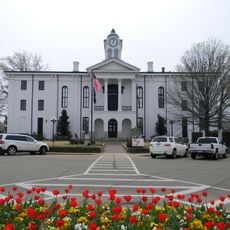
Union County is an administrative division in northern Mississippi. The county encompasses several small towns and rural areas, with New Albany serving as its administrative center.

Union County was formed in 1870 from territories of Tippah and Pontotoc counties, with additional land from Lee County added in 1874. This creation followed the post-Civil War reorganization of Mississippi.

The population of Union County includes a mix of 77 percent White residents, 14 percent Black or African American residents, and 4 percent Hispanic residents.

Interstate 22 and U.S. Route 78 connect the area to regional destinations and make arrival straightforward. Visitors should plan ahead since facilities are spread across rural areas.

A portion of Holly Springs National Forest extends across Union County, offering forests and outdoor recreation. This forest draws nature lovers seeking trails and quiet places for outdoor activities.

The community of curious travelers

AroundUs brings together thousands of curated places, local tips, and hidden gems, enriched daily by 60,000 contributors worldwide.

Start exploring
Location
Inception
1870
Capital city
New Albany
Shares border with
Benton County, Pontotoc County, Lee County, Tippah County, Prentiss County, Lafayette County, Marshall County
GPS coordinates
34.49000,-89.00000
Latest update
December 10, 2025 15:52
Around this place
Elvis Presley Birthplace
United States of America

Elvis Presley Birthplace

39 km
Tupelo Automobile Museum
United States of America

Tupelo Automobile Museum

37.9 km
Wall Doxey State Park
United States of America

Wall Doxey State Park

46.6 km
United States of America

Lyceum

42.5 km
Lochinvar
United States of America

Lochinvar

30.6 km
Trace State Park
United States of America

Trace State Park

27.4 km
Ammadelle
United States of America

Ammadelle

49.5 km
Tombigbee State Park
United States of America

Tombigbee State Park

44.7 km
University of Mississippi Museum
United States of America

University of Mississippi Museum

50.2 km
Lafayette County Courthouse
United States of America

Lafayette County Courthouse

49.5 km
Owl Creek Mounds
United States of America

Owl Creek Mounds

48.8 km
University of Mississippi Field Station
United States of America

University of Mississippi Field Station

36.4 km
St. Peter's Episcopal Church
United States of America

St. Peter's Episcopal Church

49.8 km
Fairpark
United States of America

Fairpark

37.8 km
Oxford Courthouse Square Historic District
United States of America

Oxford Courthouse Square Historic District

49.5 km
Ripley Historic District
United States of America

Ripley Historic District

26.3 km
George Wright Young House
United States of America

George Wright Young House

37.8 km
North Broadway Historic District
United States of America

North Broadway Historic District

37.2 km
Hopewell Presbyterian Church
United States of America

Hopewell Presbyterian Church

39.3 km
First Methodist Church
United States of America

First Methodist Church

37.3 km
Downtown Booneville Historic District
United States of America

Downtown Booneville Historic District

44.1 km
Civil War Earthworks at Tallahatchie Crossing
United States of America

Civil War Earthworks at Tallahatchie Crossing

45.4 km
Stewart-Anderson House
United States of America

Stewart-Anderson House

36.8 km
Old U.S. Post Office
United States of America

Old U.S. Post Office

27.3 km
Lucius Q. C. Lamar House
United States of America

Lucius Q. C. Lamar House

49.1 km
Downtown Tupelo Historic District
United States of America

Downtown Tupelo Historic District

37.3 km
North Lamar Historic District
United States of America

North Lamar Historic District

49.5 km
Wall Doxey State Park Historic District
United States of America

Wall Doxey State Park Historic District

46.5 km
Show the full map
Administrative divisions
« Union County - Administrative division in northern Mississippi, United States » is provided by Around Us (aroundus.com). Images and texts are derived from Wikimedia project under a Creative Commons license. You are allowed to copy, distribute, and modify copies of this page, under the conditions set by the license, as long as this note is clearly visible.

Discover hidden gems everywhere you go!

From secret cafés to breathtaking viewpoints, skip the crowded tourist spots and find places that match your style. Our app makes it easy with voice search, smart filtering, route optimization, and insider tips from travelers worldwide. Download now for the complete mobile experience.

Around Us App Screenshot

A unique approach to discovering new places

Le Figaro

All the places worth exploring

France Info

A tailor-made excursion in just a few clicks

20 Minutes

Around Us
Travel Guide & Maps
Download

Send to your phone

QR Code
1

Open the camera app on your mobile.

2

Point at the QR code with your camera. A notification will appear.

3

Tap the notification to open the link.