Interstate 99

Log in to your account

AroundUs is a community-driven map of interesting places, built by curious explorers like you. It grows with every review, story, and photo you share.
Connect to save your favorite spots, contribute locations, and create personalized routes.
By continuing, you accept our Terms and Conditions and our Privacy Policy
Add to collection
Map
Suggest a change
Share

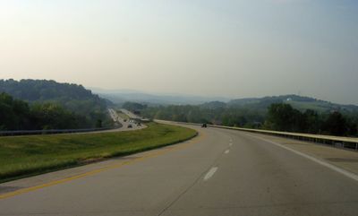
Interstate 99, Interstate highway in central Pennsylvania, United States.

Interstate 99 is a major highway in central Pennsylvania that runs through mountainous terrain, linking Bedford County with Centre County and connecting several communities along the way. The route includes multiple exits, rest areas, and service facilities positioned throughout its length.

Construction of this interstate began in 1969, with the initial section opening between Bedford Springs and Exit 3. The completion of the full route represented a major infrastructure achievement for central Pennsylvania.

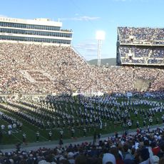
This route serves as a main link to Pennsylvania State University in State College, where thousands of students and staff depend on it for travel each year. The road has shaped how people access this major educational center in the region.

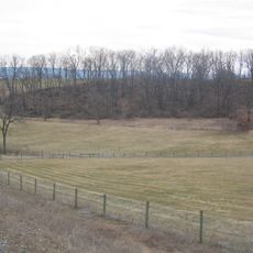
This route offers direct access to major cities including Altoona and State College, making travel through the region straightforward. Travelers should be prepared for hilly terrain and changing weather conditions, particularly during winter months.

This highway received its number through special legislation rather than following the standard numbering system for interstate highways. This makes it a notable exception in the American road network.

Location: Bedford County

Location: Blair County

Location: Centre County

Location: Steuben County

Inception: November 6, 1998

GPS coordinates: 40.83028,-77.96000

Latest update: December 6, 2025 21:31

Photos
Around this place
Show the full map
Beaver Stadium
United States of America

Beaver Stadium

9 km
Black Moshannon State Park
United States of America

Black Moshannon State Park

11.1 km
Nittany Lion Shrine
United States of America

Nittany Lion Shrine

8.5 km
Octacube
United States of America

Octacube

9 km
Palmer Museum of Art
United States of America

Palmer Museum of Art

8.6 km
The Arboretum at Penn State
United States of America

The Arboretum at Penn State

8.6 km
Garfield Thomas Water Tunnel
United States of America

Garfield Thomas Water Tunnel

8.8 km
Farmers' High School
United States of America

Farmers' High School

8.9 km
Tudek Site
United States of America

Tudek Site

9.3 km
Houserville Site
United States of America

Houserville Site

10.8 km
Centre Furnace Mansion House
United States of America

Centre Furnace Mansion House

10.2 km
Frost Entomological Museum
United States of America

Frost Entomological Museum

8.8 km
Camelot
United States of America

Camelot

9.7 km
John Gray House
United States of America

John Gray House

1.4 km
College Heights Historic District
United States of America

College Heights Historic District

8 km
Lemont Historic District
United States of America

Lemont Historic District

12.1 km
Holmes-Foster-Highlands Historic District
United States of America

Holmes-Foster-Highlands Historic District

9.4 km
Bucher Ayres Farm
United States of America

Bucher Ayres Farm

12 km
Unionville Historic District
United States of America

Unionville Historic District

11 km
Abraham Elder Stone House
United States of America

Abraham Elder Stone House

5.9 km
George Wilson Homestead
United States of America

George Wilson Homestead

12.4 km
Gen. John Thompson House
United States of America

Gen. John Thompson House

11.7 km
Felix Dale Stone House
United States of America

Felix Dale Stone House

12.7 km
Церковь Святой Троицы
United States of America

Церковь Святой Троицы

9 km
Palmer Museum at the Arboretum
United States of America

Palmer Museum at the Arboretum

8.2 km
Discovery Space
United States of America

Discovery Space

7.3 km
Black Moshannon State Park Day Use District
United States of America

Black Moshannon State Park Day Use District

12.7 km
Black Moshannon State Park Family Cabin District
United States of America

Black Moshannon State Park Family Cabin District

12.7 km
Show the full map
Reviews

Visited this place? Tap the stars to rate it and share your experience / photos with the community! Try now! You can cancel it anytime.

« Interstate 99 - Interstate highway in central Pennsylvania, United States » is provided by Around Us (aroundus.com). Images and texts are derived from Wikimedia project under a Creative Commons license. You are allowed to copy, distribute, and modify copies of this page, under the conditions set by the license, as long as this note is clearly visible.

Discover hidden gems everywhere you go!

From secret cafés to breathtaking viewpoints, skip the crowded tourist spots and find places that match your style. Our app makes it easy with voice search, smart filtering, route optimization, and insider tips from travelers worldwide. Download now for the complete mobile experience.

Around Us App Screenshot

A unique approach to discovering new places

Le Figaro

All the places worth exploring

France Info

A tailor-made excursion in just a few clicks

20 Minutes