Clay County

Log in to your account

AroundUs is a community-driven map of interesting places, built by curious explorers like you. It grows with every review, story, and photo you share.
Connect to save your favorite spots, contribute locations, and create personalized routes.
Continue with Google
Continue with Apple
Continue with X
Continue with Facebook
Continue with email
By continuing, you accept our Terms and Conditions and our Privacy Policy
Create an account
Add to collection
Map
Suggest a change
Share

Clay County, Administrative division in Indiana, US.

Clay County is an administrative division in southwestern Indiana that encompasses multiple communities and towns across its territory. The city of Brazil functions as its governmental center, housing the county offices and main public institutions.

The county was created in 1825 from territories taken from neighboring counties and named after the influential statesman Henry Clay. A significant turning point came in 1876 when the seat of government relocated, reshaping how the region was organized.

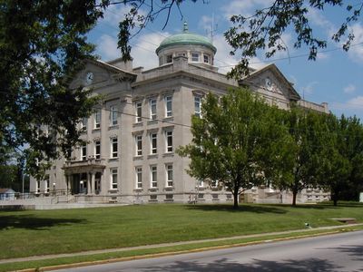
The courthouse in Brazil serves as the visual heart of the county, drawing people together for civic matters and community events. Locals navigate their daily lives around this building, making it more than just an administrative center but a social anchor for the region.

Exploring the area is best done by car, as communities are spread across the county rather than clustered together. Plan for driving time between towns and allow flexibility in your schedule when visiting multiple locations.

Local residents raised funds to move the county government from Bowling Green to Brazil, a rare example of citizens directly shaping municipal administration. This effort reveals how important control over local affairs was to early communities.

Location: Indiana

Inception: February 12, 1825

Capital city: Brazil

Shares border with: Parke County, Putnam County, Owen County, Greene County, Sullivan County, Vigo County

Website: http://claycountyin.gov

GPS coordinates: 39.40000,-87.11000

Latest update: December 7, 2025 20:45

Photos
Around this place
Cataract Falls
United States of America

Cataract Falls

25.8 km
Shakamak State Park
United States of America

Shakamak State Park

27.9 km
Cataract Falls Covered Bridge
United States of America

Cataract Falls Covered Bridge

25.8 km
United States of America

Oakley Observatory

20 km
Markle House and Mill Site
United States of America

Markle House and Mill Site

24.8 km
Brazil Downtown Historic District
United States of America

Brazil Downtown Historic District

13.9 km
Vigo County Home for Dependent Children
United States of America

Vigo County Home for Dependent Children

19.5 km
Aqueduct Bridge
United States of America

Aqueduct Bridge

10.1 km
United States Post Office
United States of America

United States Post Office

13.9 km
Indiana State Highway Bridge 46-11-1316
United States of America

Indiana State Highway Bridge 46-11-1316

7.9 km
Feeder Dam Bridge
United States of America

Feeder Dam Bridge

7.2 km
Clay County Courthouse
United States of America

Clay County Courthouse

13.9 km
Poland Presbyterian Church and Cemetery
United States of America

Poland Presbyterian Church and Cemetery

14.3 km
Butternut Hill
United States of America

Butternut Hill

22.4 km
Tide Water Pumping Station
United States of America

Tide Water Pumping Station

16.9 km
Frank Senour Round Barn
United States of America

Frank Senour Round Barn

19.4 km
Moffett-Ralston House
United States of America

Moffett-Ralston House

18.1 km
Indiana State Highway Bridge 42-11-3101
United States of America

Indiana State Highway Bridge 42-11-3101

11.2 km
Putnam County Bridge No. 159
United States of America

Putnam County Bridge No. 159

21.3 km
Lycurgus Stoner House
United States of America

Lycurgus Stoner House

26.5 km
Jeffers Bridge
United States of America

Jeffers Bridge

5.4 km
Eaglefield Place
United States of America

Eaglefield Place

18.3 km
Meridian-Forest Historic District
United States of America

Meridian-Forest Historic District

13.9 km
Memorial Stadium
United States of America

Memorial Stadium

23.6 km
Ohio Boulevard-Deming Park Historic District
United States of America

Ohio Boulevard-Deming Park Historic District

22.8 km
Houck Covered Bridge
United States of America

Houck Covered Bridge

25 km
Big Walnut Creek
United States of America

Big Walnut Creek

17.3 km
Cagles Mill Lake
United States of America

Cagles Mill Lake

20.8 km
Show the full map
Reviews

Visited this place? Tap the stars to rate it and share your experience / photos with the community! Try now! You can cancel it anytime.

Administrative divisions
« Clay County - Administrative division in Indiana, US » is provided by Around Us (aroundus.com). Images and texts are derived from Wikimedia project under a Creative Commons license. You are allowed to copy, distribute, and modify copies of this page, under the conditions set by the license, as long as this note is clearly visible.

Discover hidden gems everywhere you go!

From secret cafés to breathtaking viewpoints, skip the crowded tourist spots and find places that match your style. Our app makes it easy with voice search, smart filtering, route optimization, and insider tips from travelers worldwide. Download now for the complete mobile experience.

Around Us App Screenshot

A unique approach to discovering new places

Le Figaro

All the places worth exploring

France Info

A tailor-made excursion in just a few clicks

20 Minutes