Enable Location

We need your location to show you interesting places around you

Discover nearby places

Find interesting locations and hidden gems around you

Precise directions

Get accurate directions and distances to places

Your location is never shared with other users. It's only used when you tap the location button.

Bayview Bridge

Log in to your account

Start exploring — it's free

Trusted by 61,987 travelers worldwide

Continue with Google
Continue with Apple
or

We will send you a code to connect

By continuing, you accept our Terms and Conditions and our Privacy Policy

Check your inbox

We've sent a pincode in your inbox. Please enter the code below.

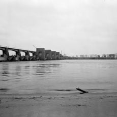
Bayview Bridge, Steel cable-stayed road bridge in West Quincy, United States.

Bayview Bridge is a cable-stayed steel structure that spans the Mississippi River and connects two counties through a road crossing. The bridge uses prefabricated steel and precast concrete sections in its construction.

This structure opened in 1987 to handle growing traffic that the previous river crossing could no longer accommodate. It represented an early application of cable-stayed design for this type of crossing.

The bridge carries traffic between two states and has become recognizable from the riverbanks below because of its distinctive cable-stayed towers. When lit at night with colored lights, it creates a landmark that locals and visitors notice from various viewpoints along the river.

The bridge is easily accessible during the day as a standard traffic route between the two counties. Specific areas accommodate pedestrians, and the structure remains visible at night due to its lighting system.

The lighting installed in 2015 uses four different colors and changes the appearance of the structure throughout the day. This system transformed the bridge into a distinctive landmark visible from multiple vantage points.

The community of curious travelers

AroundUs brings together thousands of curated places, local tips, and hidden gems, enriched daily by 60,000 contributors worldwide.

Start exploring
Location
Location
Inception
August 22, 1987
GPS coordinates
39.93330,-91.42140
Latest update
December 10, 2025 20:02
Around this place
Quincy Memorial Bridge
United States of America

Quincy Memorial Bridge

222 m
Wakonda State Park
United States of America

Wakonda State Park

11.9 km
Downtown Quincy Historic District
United States of America

Downtown Quincy Historic District

1 km
Villa Kathrine
United States of America

Villa Kathrine

1.1 km
South Side German Historic District
United States of America

South Side German Historic District

1.7 km
John Wood Mansion
United States of America

John Wood Mansion

2.3 km
Lock and Dam No. 21
United States of America

Lock and Dam No. 21

3.2 km
Quincy Rail Bridge
United States of America

Quincy Rail Bridge

1.2 km
United States of America

Adams County Courthouse

1.2 km
Robert W. Gardner House
United States of America

Robert W. Gardner House

1.4 km
Richard F. Newcomb House
United States of America

Richard F. Newcomb House

2.7 km
Quincy National Cemetery
United States of America

Quincy National Cemetery

5.6 km
Morgan-Wells House
United States of America

Morgan-Wells House

1.1 km
United States Post Office and Courthouse
United States of America

United States Post Office and Courthouse

1.6 km
A.C. Waltman House
United States of America

A.C. Waltman House

13.7 km
Ernest M. Wood Office and Studio
United States of America

Ernest M. Wood Office and Studio

1.6 km
Quincy East End Historic District
United States of America

Quincy East End Historic District

3 km
Quincy Northwest Historic District
United States of America

Quincy Northwest Historic District

1.9 km
Ursa Town Hall
United States of America

Ursa Town Hall

16.3 km
State Savings Loan and Trust
United States of America

State Savings Loan and Trust

1.1 km
William S. Warfield House
United States of America

William S. Warfield House

2.7 km
John McKoon House
United States of America

John McKoon House

14.2 km
S.J. Lesem Building
United States of America

S.J. Lesem Building

829 m
William Gray House
United States of America

William Gray House

14 km
Dr. J.A. Hay House
United States of America

Dr. J.A. Hay House

14.2 km
First Presbyterian Church
United States of America

First Presbyterian Church

14.1 km
One Thirty North Eighth Building
United States of America

One Thirty North Eighth Building

1.6 km
Quincy Museum
United States of America

Quincy Museum

2.7 km
Show the full map
« Bayview Bridge - Steel cable-stayed road bridge in West Quincy, United States » is provided by Around Us (aroundus.com). Images and texts are derived from Wikimedia project under a Creative Commons license. You are allowed to copy, distribute, and modify copies of this page, under the conditions set by the license, as long as this note is clearly visible.

Discover hidden gems everywhere you go!

From secret cafés to breathtaking viewpoints, skip the crowded tourist spots and find places that match your style. Our app makes it easy with voice search, smart filtering, route optimization, and insider tips from travelers worldwide. Download now for the complete mobile experience.

Around Us App Screenshot

A unique approach to discovering new places

Le Figaro

All the places worth exploring

France Info

A tailor-made excursion in just a few clicks

20 Minutes

Around Us
Travel Guide & Maps
Download

Send to your phone

QR Code
1

Open the camera app on your mobile.

2

Point at the QR code with your camera. A notification will appear.

3

Tap the notification to open the link.