Chest opened
+${chestReward.xp} XP
Explorer
NOUVEAU ×${chestReward.collectible.quantity}
tapez pour fermer
Chest locked

Open chests in the app

Around Us is built for your phone — chests unlock when you walk, explore and capture nearby places.

Enable Location

We need your location to show you interesting places around you

Discover nearby places

Find interesting locations and hidden gems around you

Precise directions

Get accurate directions and distances to places

Your location is never shared with other users. It's only used when you tap the location button.

Kill Van Kull

Log in to your account

Start exploring — it's free

Trusted by 72,887 travelers worldwide

Continue with Google
Continue with Apple
or

We will send you a code to connect

By continuing, you accept our Terms and Conditions and our Privacy Policy

Check your inbox

We've sent a pincode in your inbox. Please enter the code below.

Kill Van Kull
Discussion Reviews 1 Photos
29.3k Popularity

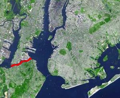
Kill Van Kull, Tidal strait between Staten Island and Bayonne, United States.

Kill Van Kull is a tidal strait running between Staten Island and Bayonne, serving as the link between Newark Bay and Upper New York Bay. The waterway cuts through industrial waterfront areas where large container vessels and other cargo ships move through to reach the ports.

Dutch settlers named this waterway in the early 17th century, marking its role as a vital passage for the region. Over the centuries it became the main shipping corridor supporting the area's expanding port economy and maritime growth.

The name combines Dutch words 'kill' for channel and 'kull' for ridge, showing how Dutch settlers left their mark on New York's geography. Today the shores are defined by working ports and industrial waterfront activity that shapes how the region functions.

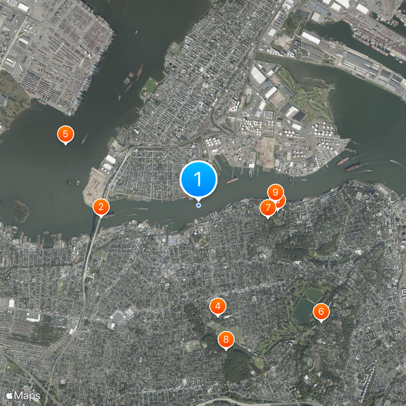
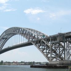
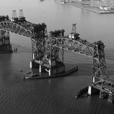
The strait is best viewed from bridges and public viewpoints along the shores, especially when large vessels pass through. The Bayonne Bridge offers the best vantage point to watch ship traffic and experience the industrial activity up close.

The Bayonne Bridge underwent a height raising project in 2017 to allow passage of larger modern container ships. This elevation shows how this passage continuously adapts to meet growing demands of global shipping traffic.

The community of curious travelers

AroundUs brings together thousands of curated places, local tips, and hidden gems, enriched daily by 60,000 contributors worldwide.

Start exploring
GPS coordinates
40.64400,-74.12000
Latest update
December 20, 2025 11:39
Around this place
Bayonne Bridge
United States of America

Bayonne Bridge

1.9 km
Sailors' Snug Harbor
United States of America

Sailors' Snug Harbor

1.5 km
Staten Island Zoo
United States of America

Staten Island Zoo

2.1 km
CRRNJ Newark Bay Bridge
United States of America

CRRNJ Newark Bay Bridge

2.8 km
Silver Lake, Staten Island
United States of America

Silver Lake, Staten Island

3.2 km
United States of America

The New York Chinese Scholar's Garden

1.3 km
Clove Lake Park
United States of America

Clove Lake Park

2.8 km
Staten Island Museum
United States of America

Staten Island Museum

1.5 km
Casa Belvedere
United States of America

Casa Belvedere

3.2 km
Staten Island Children's Museum
United States of America

Staten Island Children's Museum

1.5 km
United States of America

Staten Island Botanical Garden

1.4 km
Gardiner-Tyler House
United States of America

Gardiner-Tyler House

2.4 km
St. Joseph Cathedral
United States of America

St. Joseph Cathedral

2.3 km
Bayonne Community Museum
United States of America

Bayonne Community Museum

1.3 km
United States of America

Reformed Church on Staten Island

1.2 km
Sacred Heart Church
United States of America

Sacred Heart Church

1.1 km
Hale-Whitney Mansion
United States of America

Hale-Whitney Mansion

888 m
Bayonne Public Library
United States of America

Bayonne Public Library

3.1 km
Temple Emanu-El
United States of America

Temple Emanu-El

1.7 km
First Reformed Dutch Church of Bergen Neck
United States of America

First Reformed Dutch Church of Bergen Neck

3.3 km
Christ Church New Brighton
United States of America

Christ Church New Brighton

2.3 km
Dr. Samuel MacKenzie Elliott House
United States of America

Dr. Samuel MacKenzie Elliott House

821 m
Kreuzer-Pelton House
United States of America

Kreuzer-Pelton House

682 m
Hamilton Park Community Houses
United States of America

Hamilton Park Community Houses

2.5 km
Peter Houseman House
United States of America

Peter Houseman House

3.4 km
Scott-Edwards House
United States of America

Scott-Edwards House

1.7 km
Assumption – St. Paul
United States of America

Assumption – St. Paul

2.8 km
Neville House
United States of America

Neville House

1.8 km
Show the full map
Reviews
Share your experience

No review yet

Discussions
Start a discussion...

No discussion yet

« Kill Van Kull - Tidal strait between Staten Island and Bayonne, United States » is provided by Around Us (aroundus.com). Images and texts are derived from Wikimedia project under a Creative Commons license. You are allowed to copy, distribute, and modify copies of this page, under the conditions set by the license, as long as this note is clearly visible.

Discover hidden gems everywhere you go!

From secret cafés to breathtaking viewpoints, skip the crowded tourist spots and find places that match your style. Our app makes it easy with voice search, smart filtering, route optimization, and insider tips from travelers worldwide. Download now for the complete mobile experience.

Around Us App Screenshot

A unique approach to discovering new places

Le Figaro

All the places worth exploring

France Info

A tailor-made excursion in just a few clicks

20 Minutes

Around Us
Travel Guide & Maps
Download

Send to your phone

QR Code
1

Open the camera app on your mobile.

2

Point at the QR code with your camera. A notification will appear.

3

Tap the notification to open the link.