Mount Greylock

Log in to your account

AroundUs is a community-driven map of interesting places, built by curious explorers like you. It grows with every review, story, and photo you share.
Connect to save your favorite spots, contribute locations, and create personalized routes.
Continue with Google
Continue with Apple
Continue with X
Continue with Facebook
Continue with email
By continuing, you accept our Terms and Conditions and our Privacy Policy
Create an account
Add to collection
Map
Suggest a change
Share

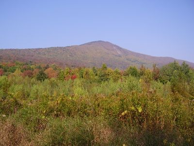
Mount Greylock, Mountain summit in Berkshire County, Massachusetts, United States

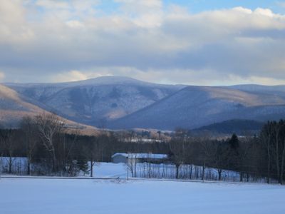
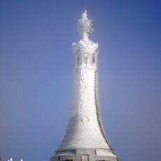
Mount Greylock rises to 3491 feet (1064 meters), forming the highest point in Massachusetts with views that extend up to 90 miles (145 kilometers) in clear weather. The summit holds a 20th-century war memorial, an operated lodge, and a shelter for winter visitors.

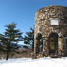
Williams College students began improving access routes to the summit in 1830, leading to the development of recreational facilities. The current tower memorial was built in 1932 after World War I to honor fallen soldiers from Massachusetts.

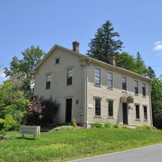
The mountain takes its name from a Wabanaki chief whose stories are still told in the region today. Visitors can see the stone lodge at the top, which has welcomed hikers for decades and serves as a gathering place.

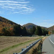
The access road stays open from May through October, while hiking trails remain available year-round and require between one and four hours of ascent depending on fitness level. Fog can limit visibility significantly, so visiting on clear days offers better distance views.

The observation deck of the 93-foot (28-meter) tower offers eight windows that light up at night and remain visible across much of the surrounding area. On very clear days, visitors can see up to five states at once, including Vermont and New York.

Location: Massachusetts

Inception: 1830

Elevation above the sea: 1,064 m

GPS coordinates: 42.63726,-73.16601

Latest update: December 13, 2025 17:04

Photos
Around this place
Mohawk Trail
United States of America

Mohawk Trail

17.4 km
Mount Greylock State Reservation
United States of America

Mount Greylock State Reservation

4 km
Berkshire Scenic Railway Museum
United States of America

Berkshire Scenic Railway Museum

4.2 km
Western Gateway Heritage State Park
United States of America

Western Gateway Heritage State Park

7.9 km
Mount Fitch
United States of America

Mount Fitch

2.1 km
Anthony House
United States of America

Anthony House

5.7 km
Wells House
United States of America

Wells House

7.3 km
Blackinton Historic District
United States of America

Blackinton Historic District

7.9 km
Stafford Hill Memorial
United States of America

Stafford Hill Memorial

8.1 km
The Boardman
United States of America

The Boardman

7.9 km
Congregation Beth Israel
United States of America

Congregation Beth Israel

6.8 km
Pittsfield and North Adams Railroad
United States of America

Pittsfield and North Adams Railroad

4.2 km
Quaker Meetinghouse
United States of America

Quaker Meetinghouse

3.5 km
Hillside Cemetery
United States of America

Hillside Cemetery

7.8 km
Church Street Historic District
United States of America

Church Street Historic District

8.2 km
Five Corners Historic District
United States of America

Five Corners Historic District

6.7 km
Hoosac Street School
United States of America

Hoosac Street School

4.5 km
Freeman's Grove Historic District
United States of America

Freeman's Grove Historic District

7.8 km
St. Luke's Episcopal Church
United States of America

St. Luke's Episcopal Church

6.6 km
Charles Browne House
United States of America

Charles Browne House

7.2 km
Crowley House
United States of America

Crowley House

7.6 km
Eber Sherman Farm
United States of America

Eber Sherman Farm

7.1 km
Church Street-Caddy Hill Historic District
United States of America

Church Street-Caddy Hill Historic District

8.2 km
William B. Sherman Farm
United States of America

William B. Sherman Farm

7.1 km
Sykes House
United States of America

Sykes House

7.4 km
Summer Street Historic District
United States of America

Summer Street Historic District

4.5 km
Normal School Historic District
United States of America

Normal School Historic District

7.9 km
Monument Square-Eagle Street Historic District
United States of America

Monument Square-Eagle Street Historic District

8 km
Show the full map
Reviews

Visited this place? Tap the stars to rate it and share your experience / photos with the community! Try now! You can cancel it anytime.

« Mount Greylock - Mountain summit in Berkshire County, Massachusetts, United States » is provided by Around Us (aroundus.com). Images and texts are derived from Wikimedia project under a Creative Commons license. You are allowed to copy, distribute, and modify copies of this page, under the conditions set by the license, as long as this note is clearly visible.

Discover hidden gems everywhere you go!

From secret cafés to breathtaking viewpoints, skip the crowded tourist spots and find places that match your style. Our app makes it easy with voice search, smart filtering, route optimization, and insider tips from travelers worldwide. Download now for the complete mobile experience.

Around Us App Screenshot

A unique approach to discovering new places

Le Figaro

All the places worth exploring

France Info

A tailor-made excursion in just a few clicks

20 Minutes