Enable Location

We need your location to show you interesting places around you

Discover nearby places

Find interesting locations and hidden gems around you

Precise directions

Get accurate directions and distances to places

Your location is never shared with other users. It's only used when you tap the location button.

Mount Greylock State Reservation

Log in to your account

Start exploring — it's free

Trusted by 64,610 travelers worldwide

Continue with Google
Continue with Apple
or

We will send you a code to connect

By continuing, you accept our Terms and Conditions and our Privacy Policy

Check your inbox

We've sent a pincode in your inbox. Please enter the code below.

Mount Greylock State Reservation
Discussion Reviews 3 Photos
6k Popularity

Mount Greylock State Reservation, Nature reserve and state park in Adams, Massachusetts.

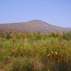
Mount Greylock State Reservation is a nature reserve and state park in northwestern Massachusetts, covering land across six towns with a wide network of hiking trails through forests, valleys, and open ridgelines. The high point of the park is the summit of Mount Greylock, which is the tallest peak in the state.

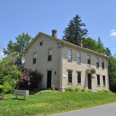
Massachusetts established a commission in 1898 to protect the area and began buying land, making it one of the earliest state efforts of its kind in the country. In the following decades, structures like Bascom Lodge and the War Memorial Tower were added to the summit, giving the park its current character.

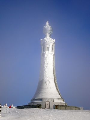
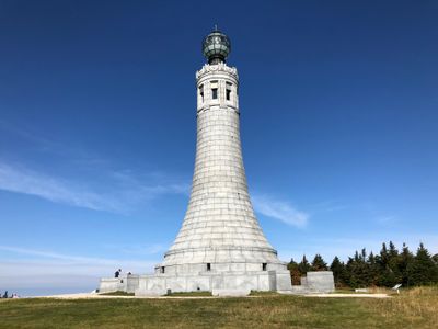
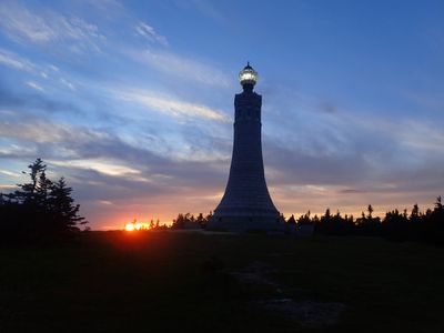
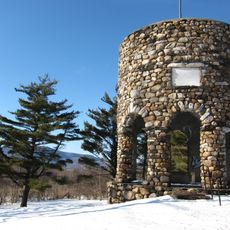
The War Memorial Tower at the summit was built to honor Massachusetts soldiers and is the first thing most visitors notice when they reach the top. Many people gather around it on clear days, drawn as much by what it represents as by the view it frames.

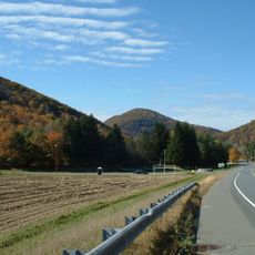
Road access to the summit is seasonal and typically closed during winter, so it is worth checking conditions before you go. Trails range from easy forest walks to steeper sections, so good footwear makes a real difference regardless of which route you choose.

The Appalachian Trail passes through the reservation for roughly 11 miles (18 km), making the summit a notable stop for long-distance hikers on their way between Georgia and Maine. Bascom Lodge, sitting right at the top, is one of the very few places along the entire trail where hikers can sleep indoors.

The community of curious travelers

AroundUs brings together thousands of curated places, local tips, and hidden gems, enriched daily by 60,000 contributors worldwide.

Start exploring
Location
Inception
1898
Operator
DCR - Division Of State Parks And Recreation
GPS coordinates
42.60230,-73.17630
Latest update
March 3, 2026 22:40
Around this place
Mount Greylock
United States of America

Mount Greylock

4 km
Mohawk Trail
United States of America

Mohawk Trail

18.7 km
Berkshire Scenic Railway Museum
United States of America

Berkshire Scenic Railway Museum

5.5 km
Field Farm
United States of America

Field Farm

9.9 km
Mount Fitch
United States of America

Mount Fitch

6.1 km
Anthony House
United States of America

Anthony House

6.2 km
Wells House
United States of America

Wells House

11.2 km
Blackinton Historic District
United States of America

Blackinton Historic District

11.5 km
Stafford Hill Memorial
United States of America

Stafford Hill Memorial

5.8 km
The Boardman
United States of America

The Boardman

11.6 km
Congregation Beth Israel
United States of America

Congregation Beth Israel

10.7 km
Pittsfield and North Adams Railroad
United States of America

Pittsfield and North Adams Railroad

5.2 km
Quaker Meetinghouse
United States of America

Quaker Meetinghouse

5 km
Hillside Cemetery
United States of America

Hillside Cemetery

11.7 km
Five Corners Historic District
United States of America

Five Corners Historic District

8.4 km
Hoosac Street School
United States of America

Hoosac Street School

5.7 km
Farnams Village Historic District
United States of America

Farnams Village Historic District

6.4 km
Boston Finishing Works
United States of America

Boston Finishing Works

11.8 km
Freeman's Grove Historic District
United States of America

Freeman's Grove Historic District

11.6 km
St. Luke's Episcopal Church
United States of America

St. Luke's Episcopal Church

4.4 km
Charles Browne House
United States of America

Charles Browne House

10.7 km
Cheshire Town Hall Complex
United States of America

Cheshire Town Hall Complex

4.6 km
Crowley House
United States of America

Crowley House

11.6 km
Eber Sherman Farm
United States of America

Eber Sherman Farm

11 km
William B. Sherman Farm
United States of America

William B. Sherman Farm

11 km
Pettibone Farm
United States of America

Pettibone Farm

7.9 km
Sykes House
United States of America

Sykes House

11.3 km
Summer Street Historic District
United States of America

Summer Street Historic District

5.2 km
Show the full map
Reviews
Share your experience

No review yet

Discussions
Start a discussion...

No discussion yet

« Mount Greylock State Reservation - Nature reserve and state park in Adams, Massachusetts » is provided by Around Us (aroundus.com). Images and texts are derived from Wikimedia project under a Creative Commons license. You are allowed to copy, distribute, and modify copies of this page, under the conditions set by the license, as long as this note is clearly visible.

Discover hidden gems everywhere you go!

From secret cafés to breathtaking viewpoints, skip the crowded tourist spots and find places that match your style. Our app makes it easy with voice search, smart filtering, route optimization, and insider tips from travelers worldwide. Download now for the complete mobile experience.

Around Us App Screenshot

A unique approach to discovering new places

Le Figaro

All the places worth exploring

France Info

A tailor-made excursion in just a few clicks

20 Minutes

Around Us
Travel Guide & Maps
Download

Send to your phone

QR Code
1

Open the camera app on your mobile.

2

Point at the QR code with your camera. A notification will appear.

3

Tap the notification to open the link.