Chest opened
+${chestReward.xp} XP
Explorer
NOUVEAU ×${chestReward.collectible.quantity}
tapez pour fermer
Chest locked

Open chests in the app

Around Us is built for your phone — chests unlock when you walk, explore and capture nearby places.

Enable Location

We need your location to show you interesting places around you

Discover nearby places

Find interesting locations and hidden gems around you

Precise directions

Get accurate directions and distances to places

Your location is never shared with other users. It's only used when you tap the location button.

Naval Station Norfolk

Log in to your account

Start exploring — it's free

Trusted by 72,888 travelers worldwide

Continue with Google
Continue with Apple
or

We will send you a code to connect

By continuing, you accept our Terms and Conditions and our Privacy Policy

Check your inbox

We've sent a pincode in your inbox. Please enter the code below.

Naval Station Norfolk
Discussion Reviews 1 Photos
169k Popularity

Naval Station Norfolk, Naval base in Norfolk, US

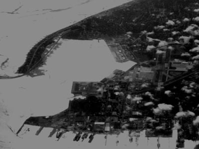
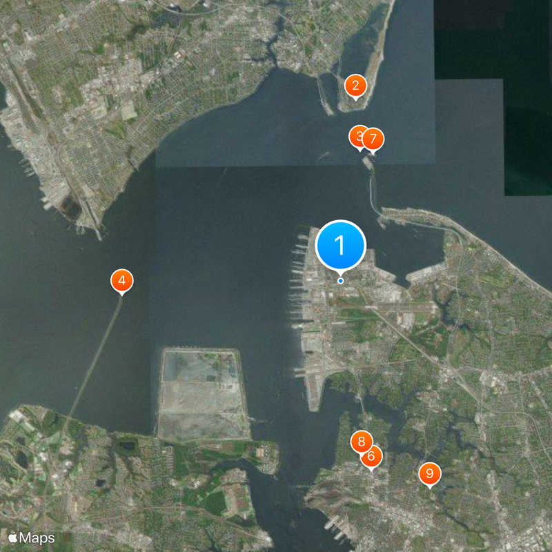
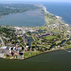
Naval Station Norfolk is a naval base in Norfolk, United States, stretching along more than 4 miles (6.4 km) of waterfront with fourteen piers for large warships. The grounds include an airfield called Chambers Field with eleven aircraft hangars, dry storage areas for decommissioned vessels, and shipyards for repairs.

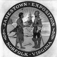
The site originated on the grounds of the 1907 Jamestown Exposition and officially opened as a naval station on July 4, 1917. In the decades following World War I, the installation grew through extensive land reclamation and harbor expansion to its current size.

The installation functions as a self-contained town with its own zip code, post office, fire department, police force, and schools for military families. On designated family days, civilians can visit the grounds and tour selected vessels, where sailors demonstrate their work areas.

Tours for civilians are only available during special events or through approved tour operators and require advance registration with security clearance. Allow several hours for a visit, as the grounds cover a large area and walking between key points takes considerable time.

More than three thousand ship movements are coordinated here every year, making this the largest concentration of naval forces worldwide. Some decommissioned ships remain anchored here for years, forming what is known as a ghost fleet before being scrapped.

The community of curious travelers

AroundUs brings together thousands of curated places, local tips, and hidden gems, enriched daily by 60,000 contributors worldwide.

Start exploring
Location
Part of
United States Fleet Forces Command
GPS coordinates
36.94500,-76.31330
Latest update
December 12, 2025 20:56
Around this place
Fort Monroe
United States of America

Fort Monroe

6.5 km
Hampton Roads Bridge–Tunnel
United States of America

Hampton Roads Bridge–Tunnel

4.7 km
Monitor-Merrimac Memorial Bridge-Tunnel
United States of America

Monitor-Merrimac Memorial Bridge-Tunnel

7.9 km
Jamestown Exposition
United States of America

Jamestown Exposition

636 m
Ted Constant Convocation Center
United States of America

Ted Constant Convocation Center

6.9 km
Fort Wool
United States of America

Fort Wool

4.7 km
S.B. Ballard Stadium
United States of America

S.B. Ballard Stadium

6.3 km
Virginia Zoological Park
United States of America

Virginia Zoological Park

8.1 km
The Chamberlin
United States of America

The Chamberlin

6.2 km
Hampton National Cemetery
United States of America

Hampton National Cemetery

8.4 km
Newport News Middle Ground Light
United States of America

Newport News Middle Ground Light

7 km
Commodore Levy Chapel
United States of America

Commodore Levy Chapel

508 m
Chapel of the Centurion
United States of America

Chapel of the Centurion

6.5 km
Herbert House
United States of America

Herbert House

8.4 km
Quarters 1
United States of America

Quarters 1

6.6 km
Quarters 17
United States of America

Quarters 17

6.4 km
Talbot Hall
United States of America

Talbot Hall

5.2 km
Boush-Tazewell House
United States of America

Boush-Tazewell House

5.2 km
Craney Island Light
United States of America

Craney Island Light

6.3 km
Norfolk and Western Railroad Historic District
United States of America

Norfolk and Western Railroad Historic District

8.2 km
Lambert Point Light
United States of America

Lambert Point Light

8 km
Reuben Clark House
United States of America

Reuben Clark House

7.8 km
Saint Mary's Catholic Cemetery
United States of America

Saint Mary's Catholic Cemetery

8.4 km
Zion Methodist Church
United States of America

Zion Methodist Church

7.5 km
William H. Trusty House
United States of America

William H. Trusty House

8.6 km
Outlook Beach
United States of America

Outlook Beach

7.7 km
Old Point Comfort Light
United States of America

Old Point Comfort Light

6.3 km
American Theater
United States of America

American Theater

8 km
Show the full map
Reviews
Share your experience

No review yet

Discussions
Start a discussion...

No discussion yet

« Naval Station Norfolk - Naval base in Norfolk, US » is provided by Around Us (aroundus.com). Images and texts are derived from Wikimedia project under a Creative Commons license. You are allowed to copy, distribute, and modify copies of this page, under the conditions set by the license, as long as this note is clearly visible.

Discover hidden gems everywhere you go!

From secret cafés to breathtaking viewpoints, skip the crowded tourist spots and find places that match your style. Our app makes it easy with voice search, smart filtering, route optimization, and insider tips from travelers worldwide. Download now for the complete mobile experience.

Around Us App Screenshot

A unique approach to discovering new places

Le Figaro

All the places worth exploring

France Info

A tailor-made excursion in just a few clicks

20 Minutes

Around Us
Travel Guide & Maps
Download

Send to your phone

QR Code
1

Open the camera app on your mobile.

2

Point at the QR code with your camera. A notification will appear.

3

Tap the notification to open the link.