Enable Location

We need your location to show you interesting places around you

Discover nearby places

Find interesting locations and hidden gems around you

Precise directions

Get accurate directions and distances to places

Your location is never shared with other users. It's only used when you tap the location button.

Stone Street Historic District

Log in to your account

Start exploring — it's free

Trusted by 62,995 travelers worldwide

Continue with Google
Continue with Apple
or

We will send you a code to connect

By continuing, you accept our Terms and Conditions and our Privacy Policy

Check your inbox

We've sent a pincode in your inbox. Please enter the code below.

Discussion Reviews 1 Photos
1.4k Popularity

Stone Street Historic District, Historic district in New Hamburg, United States

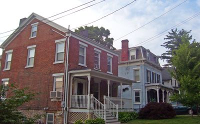
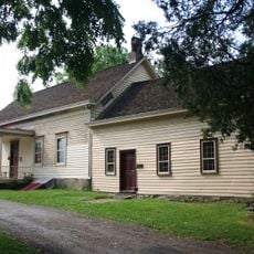
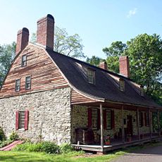
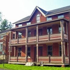
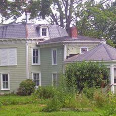
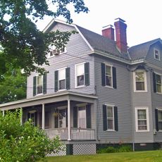
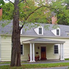
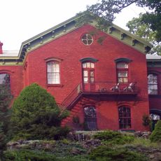
Stone Street Historic District is a residential area with eight blocks full of buildings from the 18th and 19th centuries, displaying Federal and Victorian architectural styles. The houses stand close together and form a compact residential pattern typical of urban settlements from that era.

The street began in 1767 as a simple footpath and was later expanded into a formal road connecting the town with the Hudson River. Over time it developed into an important residential street for various population groups.

The street shows traces of different communities that have lived here over generations. Visitors can still see today how these various population groups shaped the neighborhood and continue to do so.

The district extends from Division Street to Bridge Street and can be easily explored on foot. The paved streets and flat terrain make walking there pleasant and straightforward.

Houses in the district have characteristic narrow lots with small side yards but large backyards. This layout shows how land was efficiently used in the 19th century to create more living space in a smaller area.

The community of curious travelers

AroundUs brings together thousands of curated places, local tips, and hidden gems, enriched daily by 60,000 contributors worldwide.

Start exploring
Location
GPS coordinates
41.58806,-73.94806
Latest update
December 14, 2025 16:42
Around this place
Newburgh–Beacon Bridge
United States of America

Newburgh–Beacon Bridge

8.6 km
The Chapel of Sacred Mirrors
United States of America

The Chapel of Sacred Mirrors

1.3 km
Bloomer–Dailey House and Balmville Tree
United States of America

Bloomer–Dailey House and Balmville Tree

8.2 km
Van Wyck Homestead
United States of America

Van Wyck Homestead

8.8 km
Mount Gulian
United States of America

Mount Gulian

7.9 km
Main Street Historic District
United States of America

Main Street Historic District

96 m
Stony Kill Farm
United States of America

Stony Kill Farm

5.4 km
Wappingers Falls Historic District
United States of America

Wappingers Falls Historic District

2.7 km
Zion Memorial Chapel
United States of America

Zion Memorial Chapel

115 m
Dubois-Sarles Octagon
United States of America

Dubois-Sarles Octagon

2.6 km
Captain Moses W. Collyer House
United States of America

Captain Moses W. Collyer House

4.5 km
Bogardus-DeWindt House
United States of America

Bogardus-DeWindt House

8.8 km
Adolph Brower House
United States of America

Adolph Brower House

208 m
Hemlock Ridge Multiple Use Area
United States of America

Hemlock Ridge Multiple Use Area

8.7 km
Abraham Brower House
United States of America

Abraham Brower House

167 m
Joseph Horton House
United States of America

Joseph Horton House

7.4 km
Wappingers Falls Village Hall
United States of America

Wappingers Falls Village Hall

2.7 km
Fishkill Village District
United States of America

Fishkill Village District

7 km
Dutchess Company Superintendent's House
United States of America

Dutchess Company Superintendent's House

2 km
Cornelius Carman House
United States of America

Cornelius Carman House

4.7 km
United States of America

Lattingtown Baptist Church

7.9 km
Saint Mark's Episcopal Church
United States of America

Saint Mark's Episcopal Church

4.4 km
Echo Lawn Estate
United States of America

Echo Lawn Estate

7.7 km
Elliot–Buckley House
United States of America

Elliot–Buckley House

1.9 km
William Shay Double House
United States of America

William Shay Double House

208 m
Union Free School
United States of America

Union Free School

271 m
Shay's Warehouse and Stable
United States of America

Shay's Warehouse and Stable

155 m
Balmville Tree
United States of America

Balmville Tree

8.2 km
Show the full map
Reviews
Share your experience

No review yet

Discussions
Start a discussion...

No discussion yet

« Stone Street Historic District - Historic district in New Hamburg, United States » is provided by Around Us (aroundus.com). Images and texts are derived from Wikimedia project under a Creative Commons license. You are allowed to copy, distribute, and modify copies of this page, under the conditions set by the license, as long as this note is clearly visible.

Discover hidden gems everywhere you go!

From secret cafés to breathtaking viewpoints, skip the crowded tourist spots and find places that match your style. Our app makes it easy with voice search, smart filtering, route optimization, and insider tips from travelers worldwide. Download now for the complete mobile experience.

Around Us App Screenshot

A unique approach to discovering new places

Le Figaro

All the places worth exploring

France Info

A tailor-made excursion in just a few clicks

20 Minutes

Around Us
Travel Guide & Maps
Download

Send to your phone

QR Code
1

Open the camera app on your mobile.

2

Point at the QR code with your camera. A notification will appear.

3

Tap the notification to open the link.