Chest opened
+${chestReward.xp} XP
Explorer
NOUVEAU ×${chestReward.collectible.quantity}
tapez pour fermer
Chest locked

Open chests in the app

Around Us is built for your phone — chests unlock when you walk, explore and capture nearby places.

Enable Location

We need your location to show you interesting places around you

Discover nearby places

Find interesting locations and hidden gems around you

Precise directions

Get accurate directions and distances to places

Your location is never shared with other users. It's only used when you tap the location button.

Assawoman Bay

Log in to your account

Start exploring — it's free

Trusted by 72,924 travelers worldwide

Continue with Google
Continue with Apple
or

We will send you a code to connect

By continuing, you accept our Terms and Conditions and our Privacy Policy

Check your inbox

We've sent a pincode in your inbox. Please enter the code below.

Assawoman Bay
Discussion Reviews 1 Photos
12.2k Popularity

Assawoman Bay, Body of water between Worcester County, Maryland and Sussex County, Delaware, US

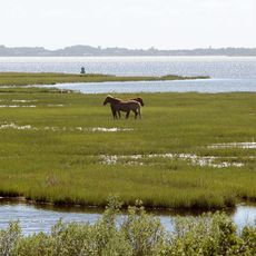
Assawoman Bay is a body of water straddling the Maryland-Delaware border, characterized by salt marshes and estuarine environments throughout its expanse. The bay supports diverse fish populations and provides resting grounds for migratory birds moving through the region seasonally.

Native American tribes established fishing grounds and travel routes in these waters long ago, with the name deriving from an Algonquian word meaning 'midway fishing stream'. The area has maintained its maritime importance through centuries of human activity.

Local fishing communities continue to practice their trades here, and the bay remains central to how residents teach younger generations about marine conservation. Visitors can see this living connection to maritime life through ongoing activities and gatherings.

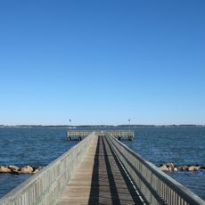
Public boat ramps and access points at multiple locations let visitors launch small vessels, with parking facilities situated near Ocean City. Spring through fall offers the most pleasant conditions for exploring the water and observing wildlife.

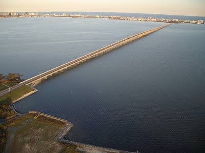
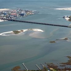
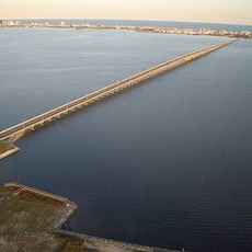
A natural channel called 'The Ditch' links this water to Little Assawoman Bay while crossing the historic Transpeninsular Line that once marked a colonial boundary. This quirk of geography shows how water flows regardless of human-drawn borders.

The community of curious travelers

AroundUs brings together thousands of curated places, local tips, and hidden gems, enriched daily by 60,000 contributors worldwide.

Start exploring
Location
Location
GPS coordinates
38.41667,-75.08333
Latest update
December 7, 2025 20:46
Around this place
Assateague State Park
United States of America

Assateague State Park

21.5 km
Indian River Inlet Bridge
United States of America

Indian River Inlet Bridge

21.4 km
Jolly Roger Amusement Park
United States of America

Jolly Roger Amusement Park

6.3 km
Trimper's Rides
United States of America

Trimper's Rides

10 km
Fenwick Island State Park
United States of America

Fenwick Island State Park

7.2 km
Fenwick Island Light
United States of America

Fenwick Island Light

4.6 km
Holts Landing State Park
United States of America

Holts Landing State Park

19.6 km
Harry W. Kelley Memorial Bridge
United States of America

Harry W. Kelley Memorial Bridge

9.3 km
Assawoman Bay Bridge
United States of America

Assawoman Bay Bridge

3.2 km
Rackliffe House
United States of America

Rackliffe House

16.1 km
Calvin B. Taylor House
United States of America

Calvin B. Taylor House

15.6 km
St. Martin's Episcopal Church
United States of America

St. Martin's Episcopal Church

10.9 km
Merry Sherwood
United States of America

Merry Sherwood

17.4 km
Burley Manor
United States of America

Burley Manor

16.1 km
Blackwater Presbyterian Church
United States of America

Blackwater Presbyterian Church

15.9 km
Berlin Commercial District
United States of America

Berlin Commercial District

15.7 km
Thunder Lagoon Water Park
United States of America

Thunder Lagoon Water Park

4.8 km
Capt. Ebe Chandler House
United States of America

Capt. Ebe Chandler House

17.2 km
Caleb's Discovery
United States of America

Caleb's Discovery

14.3 km
Henry's Grove
United States of America

Henry's Grove

17.4 km
Isaac Harmon Farmhouse
United States of America

Isaac Harmon Farmhouse

22.6 km
Dinker-Irvin House
United States of America

Dinker-Irvin House

13.7 km
Tunnell-West House
United States of America

Tunnell-West House

14.6 km
Captain Robert S. Craig Cottage
United States of America

Captain Robert S. Craig Cottage

8.6 km
United States of America

Spring Banke

15.9 km
Evans–West House
United States of America

Evans–West House

14.5 km
Ocean City Life-Saving Station
United States of America

Ocean City Life-Saving Station

10.2 km
Bethany Beach
United States of America

Bethany Beach

14.1 km
Show the full map
Reviews
Share your experience

No review yet

Discussions
Start a discussion...

No discussion yet

« Assawoman Bay - Body of water between Worcester County, Maryland and Sussex County, Delaware, US » is provided by Around Us (aroundus.com). Images and texts are derived from Wikimedia project under a Creative Commons license. You are allowed to copy, distribute, and modify copies of this page, under the conditions set by the license, as long as this note is clearly visible.

Discover hidden gems everywhere you go!

From secret cafés to breathtaking viewpoints, skip the crowded tourist spots and find places that match your style. Our app makes it easy with voice search, smart filtering, route optimization, and insider tips from travelers worldwide. Download now for the complete mobile experience.

Around Us App Screenshot

A unique approach to discovering new places

Le Figaro

All the places worth exploring

France Info

A tailor-made excursion in just a few clicks

20 Minutes

Around Us
Travel Guide & Maps
Download

Send to your phone

QR Code
1

Open the camera app on your mobile.

2

Point at the QR code with your camera. A notification will appear.

3

Tap the notification to open the link.