Enable Location

We need your location to show you interesting places around you

Discover nearby places

Find interesting locations and hidden gems around you

Precise directions

Get accurate directions and distances to places

Your location is never shared with other users. It's only used when you tap the location button.

Breckenridge Reservoir

Log in to your account

Start exploring — it's free

Trusted by 62,447 travelers worldwide

Continue with Google
Continue with Apple
or

We will send you a code to connect

By continuing, you accept our Terms and Conditions and our Privacy Policy

Check your inbox

We've sent a pincode in your inbox. Please enter the code below.

Breckenridge Reservoir

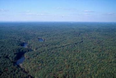
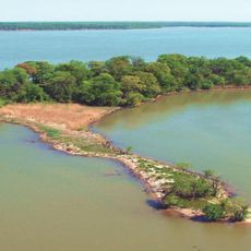
Breckenridge Reservoir, on Chopawamsic Creek, Virginia

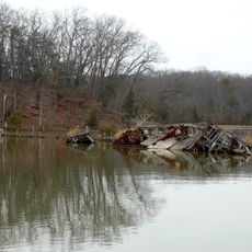
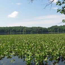
Breckenridge Reservoir is a quiet body of water in Prince William County surrounded by trees with a natural shoreline. The water is shallow and calm, making it suitable for small boats like canoes and kayaks, while only electric-powered boats are permitted on the surface.

The reservoir was built several decades ago to supply water for nearby communities. It is part of a larger network of lakes in the region serving both practical needs and outdoor recreation.

Visitors come here mainly for quiet fishing, spending hours casting lines and waiting by the water's edge. The place appeals to those seeking a simple outdoor experience where the natural setting takes priority over facilities or attractions.

You can access the water at the New Breckenridge Road Boat Launch where the parking lot is located. Bring all necessary gear and supplies with you since there are no stores or major facilities nearby.

The water becomes especially shallow during dry summer months, requiring visitors to use smaller boats or kayaks for access. This seasonal fluctuation is part of what makes the location naturally challenging yet rewarding for anglers.

The community of curious travelers

AroundUs brings together thousands of curated places, local tips, and hidden gems, enriched daily by 60,000 contributors worldwide.

Start exploring
GPS coordinates
38.54302,-77.39590
Latest update
February 9, 2026 08:21
Around this place
Mallows Bay
United States of America

Mallows Bay

13.6 km
National Museum of the Marine Corps
United States of America

National Museum of the Marine Corps

4.6 km
Weems–Botts Museum
United States of America

Weems–Botts Museum

6.4 km
Leesylvania State Park
United States of America

Leesylvania State Park

13.3 km
Quantico National Cemetery
United States of America

Quantico National Cemetery

2.7 km
Aquia Creek
United States of America

Aquia Creek

14.2 km
Bel Air
United States of America

Bel Air

11.2 km
Public Quarry at Government Island
United States of America

Public Quarry at Government Island

10.6 km
Marine Raider Museum
United States of America

Marine Raider Museum

6.2 km
Aquia Church
United States of America

Aquia Church

8.8 km
Chopawamsic
United States of America

Chopawamsic

9.5 km
Featherstone National Wildlife Refuge
United States of America

Featherstone National Wildlife Refuge

13.5 km
Waffle House
United States of America

Waffle House

7.5 km
Commanding General's Quarters, Quantico Marine Base
United States of America

Commanding General's Quarters, Quantico Marine Base

8.5 km
Marine Corps Air-Ground Museum
United States of America

Marine Corps Air-Ground Museum

8.7 km
Freestone Point Confederate Battery
United States of America

Freestone Point Confederate Battery

13.9 km
C.D. Hylton Senior High School
United States of America

C.D. Hylton Senior High School

11.9 km
Henderson House
United States of America

Henderson House

6.4 km
Pleasant Historic District, Chopawamsic RDA Camp 4
United States of America

Pleasant Historic District, Chopawamsic RDA Camp 4

6.5 km
Cabin Branch Pyrite Mine Historic District
United States of America

Cabin Branch Pyrite Mine Historic District

5.4 km
Chopawamsic Recreational Demonstration Area Cabin Camp 1
United States of America

Chopawamsic Recreational Demonstration Area Cabin Camp 1

6.9 km
Chopawamsic RDA Camp 2
United States of America

Chopawamsic RDA Camp 2

4.6 km
Old Town Hall and School
United States of America

Old Town Hall and School

6.9 km
Orenda/SP-26 Historic District, Chopawamsic RDA Camp 3
United States of America

Orenda/SP-26 Historic District, Chopawamsic RDA Camp 3

3.9 km
Crusading for Right
United States of America

Crusading for Right

9 km
Mallows Bay – Potomac River National Marine Sanctuary
United States of America

Mallows Bay – Potomac River National Marine Sanctuary

14.2 km
Prince William Forest Park Visitor Center
United States of America

Prince William Forest Park Visitor Center

4.6 km
Prince William Forest Park Historic District
United States of America

Prince William Forest Park Historic District

3.3 km
Show the full map
« Breckenridge Reservoir - on Chopawamsic Creek, Virginia » is provided by Around Us (aroundus.com). Images and texts are derived from Wikimedia project under a Creative Commons license. You are allowed to copy, distribute, and modify copies of this page, under the conditions set by the license, as long as this note is clearly visible.

Discover hidden gems everywhere you go!

From secret cafés to breathtaking viewpoints, skip the crowded tourist spots and find places that match your style. Our app makes it easy with voice search, smart filtering, route optimization, and insider tips from travelers worldwide. Download now for the complete mobile experience.

Around Us App Screenshot

A unique approach to discovering new places

Le Figaro

All the places worth exploring

France Info

A tailor-made excursion in just a few clicks

20 Minutes

Around Us
Travel Guide & Maps
Download

Send to your phone

QR Code
1

Open the camera app on your mobile.

2

Point at the QR code with your camera. A notification will appear.

3

Tap the notification to open the link.