Enable Location

We need your location to show you interesting places around you

Discover nearby places

Find interesting locations and hidden gems around you

Precise directions

Get accurate directions and distances to places

Your location is never shared with other users. It's only used when you tap the location button.

Aquia Creek

Log in to your account

Start exploring — it's free

Trusted by 61,994 travelers worldwide

Continue with Google
Continue with Apple
or

We will send you a code to connect

By continuing, you accept our Terms and Conditions and our Privacy Policy

Check your inbox

We've sent a pincode in your inbox. Please enter the code below.

Aquia Creek

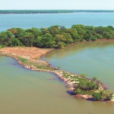
Aquia Creek, Tributary creek in Stafford County, Virginia, United States.

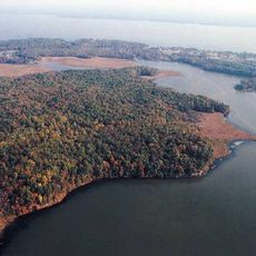
Aquia Creek is a waterway that flows from southeastern Fauquier County to meet the Potomac River at Brent Point. The creek runs through Stafford County, connecting rural communities and offering multiple places where visitors can access the water.

Sandstone was quarried from these waters between 1792 and 1799 and used for major government buildings in the nation's capital. This extractive activity was crucial to the early growth of the surrounding region.

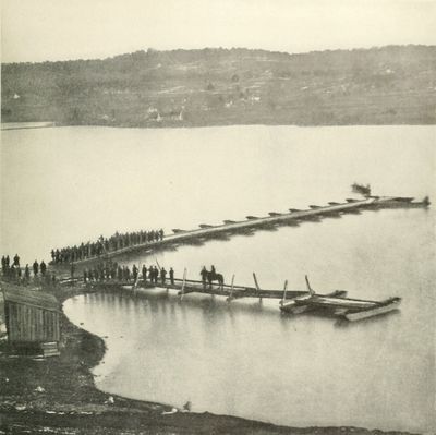
The waterway served as a vital transportation corridor for moving goods across the region in earlier times. Today, visitors can sense this working relationship between water and commerce while exploring the surrounding area.

Multiple access points along the creek allow visitors to launch kayaks and fish in the waters. Water levels and conditions change with seasons, so it helps to check local conditions before planning your visit.

A world record Northern Snakehead fish was caught in these waters in 2013, surprising fishing enthusiasts. The discovery drew attention to the unusual fish species thriving in this freshwater system.

The community of curious travelers

AroundUs brings together thousands of curated places, local tips, and hidden gems, enriched daily by 60,000 contributors worldwide.

Start exploring
Location
GPS coordinates
38.41830,-77.35910
Latest update
December 10, 2025 16:21
Around this place
Mallows Bay
United States of America

Mallows Bay

10 km
National Museum of the Marine Corps
United States of America

National Museum of the Marine Corps

14.1 km
Chatham Manor
United States of America

Chatham Manor

14.8 km
Quantico National Cemetery
United States of America

Quantico National Cemetery

13.9 km
Public Quarry at Government Island
United States of America

Public Quarry at Government Island

4 km
Marine Raider Museum
United States of America

Marine Raider Museum

11.2 km
Rising Sun Tavern
United States of America

Rising Sun Tavern

15.3 km
Aquia Church
United States of America

Aquia Church

6.4 km
Crow's Nest Natural Area Preserve
United States of America

Crow's Nest Natural Area Preserve

6.2 km
Chopawamsic
United States of America

Chopawamsic

11.4 km
Gari Melchers Home
United States of America

Gari Melchers Home

14.4 km
Potomac Creek Bridge
United States of America

Potomac Creek Bridge

8.1 km
Breckenridge Reservoir
United States of America

Breckenridge Reservoir

14.2 km
White Oak Church
United States of America

White Oak Church

13.2 km
Belle Plains, Virginia
United States of America

Belle Plains, Virginia

8.8 km
Union Church and Cemetery
United States of America

Union Church and Cemetery

14.1 km
Commanding General's Quarters, Quantico Marine Base
United States of America

Commanding General's Quarters, Quantico Marine Base

13.3 km
Marine Corps Air-Ground Museum
United States of America

Marine Corps Air-Ground Museum

10.9 km
Conway House
United States of America

Conway House

14.4 km
Clearview
United States of America

Clearview

13.9 km
Carlton
United States of America

Carlton

14.2 km
Stafford Training School
United States of America

Stafford Training School

5.6 km
Falmouth Historic District
United States of America

Falmouth Historic District

14.1 km
Elmhurst
United States of America

Elmhurst

15.4 km
Gari Melchers Home and Studio
United States of America

Gari Melchers Home and Studio

14.4 km
Crusading for Right
United States of America

Crusading for Right

12.7 km
Mallows Bay – Potomac River National Marine Sanctuary
United States of America

Mallows Bay – Potomac River National Marine Sanctuary

6.3 km
Central Rappahannock Regional Library
United States of America

Central Rappahannock Regional Library

15.4 km
Show the full map
« Aquia Creek - Tributary creek in Stafford County, Virginia, United States » is provided by Around Us (aroundus.com). Images and texts are derived from Wikimedia project under a Creative Commons license. You are allowed to copy, distribute, and modify copies of this page, under the conditions set by the license, as long as this note is clearly visible.

Discover hidden gems everywhere you go!

From secret cafés to breathtaking viewpoints, skip the crowded tourist spots and find places that match your style. Our app makes it easy with voice search, smart filtering, route optimization, and insider tips from travelers worldwide. Download now for the complete mobile experience.

Around Us App Screenshot

A unique approach to discovering new places

Le Figaro

All the places worth exploring

France Info

A tailor-made excursion in just a few clicks

20 Minutes

Around Us
Travel Guide & Maps
Download

Send to your phone

QR Code
1

Open the camera app on your mobile.

2

Point at the QR code with your camera. A notification will appear.

3

Tap the notification to open the link.