Enable Location

We need your location to show you interesting places around you

Discover nearby places

Find interesting locations and hidden gems around you

Precise directions

Get accurate directions and distances to places

Your location is never shared with other users. It's only used when you tap the location button.

Belle Plains, Virginia

Log in to your account

Start exploring — it's free

Trusted by 61,354 travelers worldwide

Continue with Google
Continue with Apple
or

We will send you a code to connect

By continuing, you accept our Terms and Conditions and our Privacy Policy

Check your inbox

We've sent a pincode in your inbox. Please enter the code below.

Belle Plains, Virginia

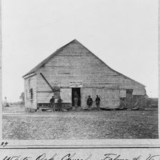
Belle Plains, Virginia, Civil War supply depot in Stafford County, US.

Description

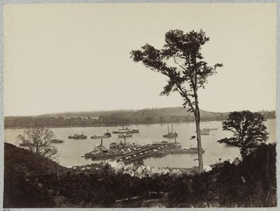
Belle Plains is a former settlement along Potomac Creek in Stafford County that served as a transportation hub for both water and overland routes. The location sits at a confluence point where boats could transfer cargo to wagons heading inland and toward Fredericksburg.

History

The settlement gained major importance as a Union supply center during 1864 when the military needed efficient distribution points for the Overland Campaign. Its location made it preferable to older landing sites that had served the army in previous campaigns.

Culture

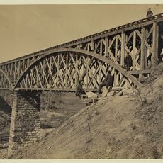
The area contains remnants of 19th-century transportation infrastructure, including former steamboat landing sites and stagecoach routes to Fredericksburg.

Practical

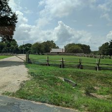
The area can be reached via local roads in Stafford County, with historical markers scattered throughout the site explaining its past role. Visitors should plan for an outdoor experience without structures, so appropriate footwear and weather-appropriate clothing are recommended.

Did you know?

The site operated as both a civilian steamboat landing and military supply center at the same time, showing how commerce and warfare were intertwined in this region. This dual purpose made it a place where civilian commerce continued even as military operations intensified nearby.

GPS coordinates
38.34261,-77.33075
Latest update
December 14, 2025 14:25

AroundUs brings together thousands of curated places, local tips, and hidden gems, enriched daily by 60,000 contributors worldwide. Discover all places nearby (United States of America).

Around this place
Ferry Farm
United States of America

Ferry Farm

11.6 km
Chatham Manor
United States of America

Chatham Manor

11.5 km
Aquia Creek
United States of America

Aquia Creek

8.8 km
Rising Sun Tavern
United States of America

Rising Sun Tavern

12.1 km
Mary Washington House
United States of America

Mary Washington House

12.3 km
Crow's Nest Natural Area Preserve
United States of America

Crow's Nest Natural Area Preserve

2.7 km
Potomac Creek Bridge
United States of America

Potomac Creek Bridge

7 km
White Oak Church
United States of America

White Oak Church

6.1 km
The Chimneys
United States of America

The Chimneys

12.1 km
Union Church and Cemetery
United States of America

Union Church and Cemetery

12.1 km
Fredericksburg Town Hall and Market Square
United States of America

Fredericksburg Town Hall and Market Square

12.1 km
Marmion
United States of America

Marmion

11 km
Conway House
United States of America

Conway House

12.2 km
Clearview
United States of America

Clearview

11.8 km
Presbyterian Church of Fredericksburg
United States of America

Presbyterian Church of Fredericksburg

12.2 km
Rokeby
United States of America

Rokeby

10.7 km
Farmers Bank of Fredericksburg
United States of America

Farmers Bank of Fredericksburg

12.2 km
Eagle's Nest
United States of America

Eagle's Nest

10.5 km
Stafford Training School
United States of America

Stafford Training School

10.4 km
Falmouth Historic District
United States of America

Falmouth Historic District

12 km
Sentry Box
United States of America

Sentry Box

12 km
George Washington's Ferry Farm
United States of America

George Washington's Ferry Farm

11.4 km
James Monroe Law Office
United States of America

James Monroe Law Office

12.3 km
Victoria Theatre
United States of America

Victoria Theatre

12.1 km
James Monroe Museum and Memorial Library
United States of America

James Monroe Museum and Memorial Library

12.3 km
Mallows Bay – Potomac River National Marine Sanctuary
United States of America

Mallows Bay – Potomac River National Marine Sanctuary

11.7 km
Fredericksburg Historic District
United States of America

Fredericksburg Historic District

12 km
Central Rappahannock Regional Library
United States of America

Central Rappahannock Regional Library

12.1 km
Show the full map
« Belle Plains, Virginia - Civil War supply depot in Stafford County, US » is provided by Around Us (aroundus.com). Images and texts are derived from Wikimedia project under a Creative Commons license. You are allowed to copy, distribute, and modify copies of this page, under the conditions set by the license, as long as this note is clearly visible.

Discover hidden gems everywhere you go!

From secret cafés to breathtaking viewpoints, skip the crowded tourist spots and find places that match your style. Our app makes it easy with voice search, smart filtering, route optimization, and insider tips from travelers worldwide. Download now for the complete mobile experience.

Around Us App Screenshot

A unique approach to discovering new places

Le Figaro

All the places worth exploring

France Info

A tailor-made excursion in just a few clicks

20 Minutes

Around Us
Travel Guide & Maps
Download

Send to your phone

QR Code
1

Open the camera app on your mobile.

2

Point at the QR code with your camera. A notification will appear.

3

Tap the notification to open the link.