Enable Location

We need your location to show you interesting places around you

Discover nearby places

Find interesting locations and hidden gems around you

Precise directions

Get accurate directions and distances to places

Your location is never shared with other users. It's only used when you tap the location button.

Black Balsam Knob

Log in to your account

Start exploring — it's free

Trusted by 62,483 travelers worldwide

Continue with Google
Continue with Apple
or

We will send you a code to connect

By continuing, you accept our Terms and Conditions and our Privacy Policy

Check your inbox

We've sent a pincode in your inbox. Please enter the code below.

Black Balsam Knob

Black Balsam Knob, Mountain summit in Pisgah National Forest, North Carolina.

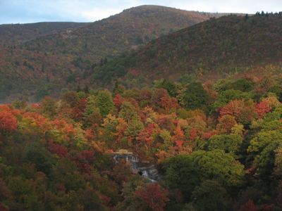
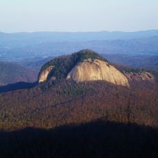
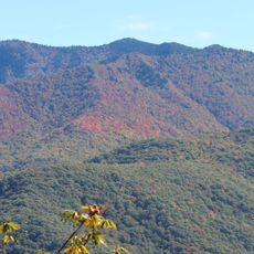
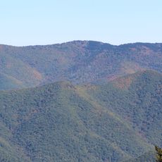
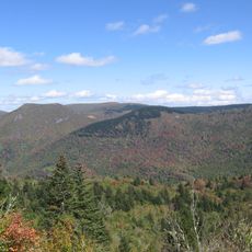
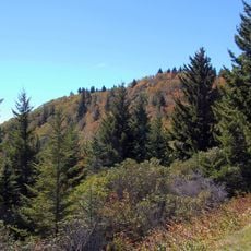
Black Balsam Knob rises to 6,214 feet and features a treeless summit with grass-covered slopes that spread across multiple ridges and peaks. The open terrain allows unobstructed views in all directions across the surrounding mountain landscape.

The current landscape resulted from extensive logging operations and subsequent fires in 1925 and 1942 that prevented forest regrowth. These events shaped the characteristic grassland that defines the summit today.

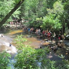
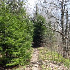
The Art Loeb Trail runs across the summit, connecting hikers to a network of paths throughout the southern Appalachian region. The route draws regular visitors who come to experience the open landscape and expansive views from the high terrain.

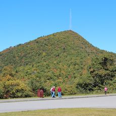
Visitors reach the summit via a short hike of about half a mile from the parking area near milepost 420 on the Blue Ridge Parkway. Temperatures on this exposed peak are typically around 8 degrees Celsius (15 degrees Fahrenheit) lower than in the surrounding areas.

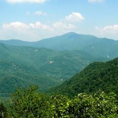
On clear days, visitors can see two famous mountain massifs - Mount Mitchell and Cold Mountain - visible from many miles away at this location. These distant views make the summit a desired spot for photography and nature observation.

The community of curious travelers

AroundUs brings together thousands of curated places, local tips, and hidden gems, enriched daily by 60,000 contributors worldwide.

Start exploring
Location
GPS coordinates
35.32785,-82.87448
Latest update
December 7, 2025 20:26
Around this place
Sliding Rock
United States of America

Sliding Rock

8.2 km
Cold Mountain
United States of America

Cold Mountain

9.2 km
Looking Glass Falls
United States of America

Looking Glass Falls

10.2 km
Art Loeb Trail
United States of America

Art Loeb Trail

5.6 km
Looking Glass Rock
United States of America

Looking Glass Rock

7.8 km
Mount Pisgah
United States of America

Mount Pisgah

15.3 km
Biltmore Forest School
United States of America

Biltmore Forest School

9 km
Shining Rock Wilderness
United States of America

Shining Rock Wilderness

4.1 km
United States of America

Pisgah Astronomical Research Institute

14.3 km
Richland Balsam
United States of America

Richland Balsam

11.4 km
Moore Cove Falls
United States of America

Moore Cove Falls

9 km
Shining Rock
United States of America

Shining Rock

4.6 km
Courthouse Falls
United States of America

Courthouse Falls

6.5 km
Slick Rock Falls
United States of America

Slick Rock Falls

8 km
Middle Prong Wilderness
United States of America

Middle Prong Wilderness

5.8 km
Tanasee Bald
United States of America

Tanasee Bald

5.6 km
Log Hollow Falls
United States of America

Log Hollow Falls

6.1 km
Robinson Rock House Ruin and Plantation Site
United States of America

Robinson Rock House Ruin and Plantation Site

15.4 km
Cedar Rock Falls
United States of America

Cedar Rock Falls

8.8 km
St. Philip's Episcopal Church
United States of America

St. Philip's Episcopal Church

16.9 km
Cradle of Forestry in America
United States of America

Cradle of Forestry in America

9.1 km
Godfrey-Barnette House
United States of America

Godfrey-Barnette House

16.8 km
Transylvania County Courthouse
United States of America

Transylvania County Courthouse

16.6 km
Main Street Historic District
United States of America

Main Street Historic District

16.5 km
William Deaver House
United States of America

William Deaver House

16.7 km
William Breese, Jr., House
United States of America

William Breese, Jr., House

16.7 km
Co-Ed Cinema
United States of America

Co-Ed Cinema

16.3 km
PARI 26m radio telescope
United States of America

PARI 26m radio telescope

14.2 km
Show the full map
« Black Balsam Knob - Mountain summit in Pisgah National Forest, North Carolina » is provided by Around Us (aroundus.com). Images and texts are derived from Wikimedia project under a Creative Commons license. You are allowed to copy, distribute, and modify copies of this page, under the conditions set by the license, as long as this note is clearly visible.

Discover hidden gems everywhere you go!

From secret cafés to breathtaking viewpoints, skip the crowded tourist spots and find places that match your style. Our app makes it easy with voice search, smart filtering, route optimization, and insider tips from travelers worldwide. Download now for the complete mobile experience.

Around Us App Screenshot

A unique approach to discovering new places

Le Figaro

All the places worth exploring

France Info

A tailor-made excursion in just a few clicks

20 Minutes

Around Us
Travel Guide & Maps
Download

Send to your phone

QR Code
1

Open the camera app on your mobile.

2

Point at the QR code with your camera. A notification will appear.

3

Tap the notification to open the link.