Enable Location

We need your location to show you interesting places around you

Discover nearby places

Find interesting locations and hidden gems around you

Precise directions

Get accurate directions and distances to places

Your location is never shared with other users. It's only used when you tap the location button.

Bull's Bridge

Log in to your account

Start exploring — it's free

Trusted by 61,560 travelers worldwide

Continue with Google
Continue with Apple
or

We will send you a code to connect

By continuing, you accept our Terms and Conditions and our Privacy Policy

Check your inbox

We've sent a pincode in your inbox. Please enter the code below.

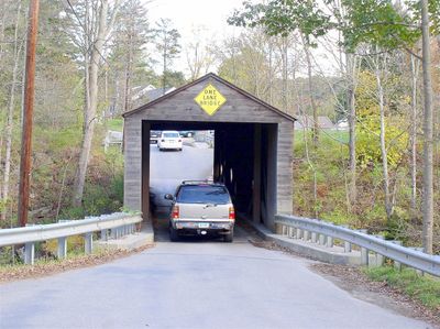
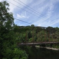
Bull's Bridge, Covered bridge in Kent, US.

Description

Bull's Bridge is a covered wooden structure spanning the Housatonic River and features a Town lattice design with visible reinforced trusswork inside the tunnel-like passage. The bridge extends approximately 109 feet and carries vehicles across the river between Kent and its neighboring communities.

History

The original bridge was built in 1760 to help transport iron from nearby foundries to Poughkeepsie. The current structure dates to 1842 when it was rebuilt to replace the earlier version that had served the same purpose for generations.

Culture

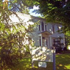
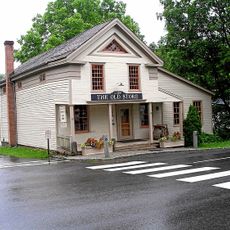
This is one of the few remaining covered bridges in Connecticut and shows how communities value preserving their historical connections across the river. The wooden structure reflects local building traditions that people continue to respect today.

Practical

The bridge is narrow and single-lane, so drivers must yield to oncoming traffic and proceed carefully. Parking areas near both ends provide easy access for visitors wanting to explore the bridge and the river surroundings.

Did you know?

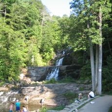
The Appalachian Trail crosses near the bridge entrance, connecting hikers to waterfalls and rapids further downstream along the river. Many visitors don't realize this historic bridge sits along one of the longest-distance hiking routes in the region.

Location
Official opening
1842
Made from material
wood
GPS coordinates
41.67560,-73.50940
Latest update
December 9, 2025 18:48

AroundUs brings together thousands of curated places, local tips, and hidden gems, enriched daily by 60,000 contributors worldwide. Discover all places nearby (Kent).

Around this place
Kent Falls State Park
United States of America

Kent Falls State Park

13.8 km
Macedonia Brook State Park
United States of America

Macedonia Brook State Park

11 km
Above All State Park
United States of America

Above All State Park

14.2 km
Pawling Nature Reserve
United States of America

Pawling Nature Reserve

9.1 km
John Kane House
United States of America

John Kane House

15.1 km
Akin Free Library
United States of America

Akin Free Library

13.4 km
Clove Mountain
United States of America

Clove Mountain

15.3 km
St. Thomas Episcopal Church
United States of America

St. Thomas Episcopal Church

16.6 km
Hunt Hill Farm
United States of America

Hunt Hill Farm

11.3 km
Flanders Historic District
United States of America

Flanders Historic District

8.3 km
Mount Bushnell State Park
United States of America

Mount Bushnell State Park

12.3 km
Tabor-Wing House
United States of America

Tabor-Wing House

9.1 km
Boardman's Bridge
United States of America

Boardman's Bridge

10.4 km
Sherman Historic District
United States of America

Sherman Historic District

10.8 km
New Preston Hill Historic District
United States of America

New Preston Hill Historic District

11.5 km
United Bank Building
United States of America

United Bank Building

13.6 km
New Milford Center Historic District
United States of America

New Milford Center Historic District

13.4 km
Merryall Union Evangelical Society Chapel
United States of America

Merryall Union Evangelical Society Chapel

8.1 km
Connecticut Antique Machinery Association
United States of America

Connecticut Antique Machinery Association

7.8 km
Capt. Philo Beardsley House
United States of America

Capt. Philo Beardsley House

10.2 km
Second Baptist Church of Dover
United States of America

Second Baptist Church of Dover

9.3 km
St. Andrew's Episcopal Church
United States of America

St. Andrew's Episcopal Church

11.7 km
E. A. Wildman & Co. Tobacco Warehouse
United States of America

E. A. Wildman & Co. Tobacco Warehouse

13.7 km
Calhoun-Ives Historic District
United States of America

Calhoun-Ives Historic District

14.8 km
Lake Waramaug State Park
United States of America

Lake Waramaug State Park

11.1 km
Kent Falls
United States of America

Kent Falls

13.8 km
Bank Street Theater
United States of America

Bank Street Theater

13.6 km
Oblong Friends Meeting House
United States of America

Oblong Friends Meeting House

11 km
Show the full map
« Bull's Bridge - Covered bridge in Kent, US » is provided by Around Us (aroundus.com). Images and texts are derived from Wikimedia project under a Creative Commons license. You are allowed to copy, distribute, and modify copies of this page, under the conditions set by the license, as long as this note is clearly visible.

Discover hidden gems everywhere you go!

From secret cafés to breathtaking viewpoints, skip the crowded tourist spots and find places that match your style. Our app makes it easy with voice search, smart filtering, route optimization, and insider tips from travelers worldwide. Download now for the complete mobile experience.

Around Us App Screenshot

A unique approach to discovering new places

Le Figaro

All the places worth exploring

France Info

A tailor-made excursion in just a few clicks

20 Minutes

Around Us
Travel Guide & Maps
Download

Send to your phone

QR Code
1

Open the camera app on your mobile.

2

Point at the QR code with your camera. A notification will appear.

3

Tap the notification to open the link.