Chest opened
+${chestReward.xp} XP
Explorer
NOUVEAU ×${chestReward.collectible.quantity}
tapez pour fermer
Chest locked

Open chests in the app

Around Us is built for your phone — chests unlock when you walk, explore and capture nearby places.

Enable Location

We need your location to show you interesting places around you

Discover nearby places

Find interesting locations and hidden gems around you

Precise directions

Get accurate directions and distances to places

Your location is never shared with other users. It's only used when you tap the location button.

Log in to your account

Start exploring — it's free

Trusted by 72,891 travelers worldwide

Continue with Google
Continue with Apple
or

We will send you a code to connect

By continuing, you accept our Terms and Conditions and our Privacy Policy

Check your inbox

We've sent a pincode in your inbox. Please enter the code below.

Chaffin's Bluff
Discussion Reviews Photo
4.3k Popularity

Chaffin's Bluff, Civil War fortification on James River, Virginia.

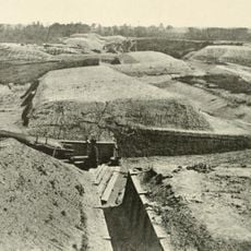
Chaffin's Bluff is a Civil War fortification located on high ground overlooking the James River north of Richmond. The site features earthen ramparts and defensive lines that once protected the river approaches to the Confederate capital.

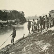
Confederate forces began constructing defenses here in 1862 to prevent Union gunboats from reaching Richmond. The position remained critical until the capital's evacuation in 1865, when the site was finally abandoned.

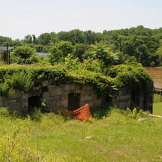
The site brought together people from different backgrounds working under harsh conditions to build and maintain military defenses. You can sense today how this location served as a meeting point shaped by conflict and forced labor.

You can walk through the site using trails maintained by Richmond National Battlefield Park, which connect different fortification areas. Spring and fall offer the most comfortable visiting conditions with clear sight lines through the earthworks.

When Confederate forces evacuated in 1865, Admiral Raphael Semmes ordered the destruction of all gunboats stationed at this location. This dramatic action prevented the warships from falling into Union hands and marked the end of this defensive stronghold.

The community of curious travelers

AroundUs brings together thousands of curated places, local tips, and hidden gems, enriched daily by 60,000 contributors worldwide.

Start exploring
Location
GPS coordinates
37.42333,-77.39778
Latest update
December 11, 2025 11:02
Around this place
Henricus
United States of America

Henricus

6.3 km
Varina Farms
United States of America

Varina Farms

7.2 km
Varina-Enon Bridge
United States of America

Varina-Enon Bridge

6.7 km
Chimborazo Park
United States of America

Chimborazo Park

2.2 km
Dutch Gap
United States of America

Dutch Gap

6.4 km
Richmond National Cemetery
United States of America

Richmond National Cemetery

10.1 km
Fort Darling
United States of America

Fort Darling

2.5 km
United States of America

Henrico City

7.2 km
James River Steam Brewery Cellars
United States of America

James River Steam Brewery Cellars

10.4 km
Fort Harrison National Cemetery
United States of America

Fort Harrison National Cemetery

2.8 km
Tree Hill
United States of America

Tree Hill

8.2 km
Magnolia Grange
United States of America

Magnolia Grange

11.1 km
Bridge at Falling Creek
United States of America

Bridge at Falling Creek

4.1 km
Armitage Manufacturing Company
United States of America

Armitage Manufacturing Company

11.5 km
Woodward House
United States of America

Woodward House

11.4 km
Robert Fulton School
United States of America

Robert Fulton School

10.4 km
American Tobacco Company, South Richmond Complex Historic District
United States of America

American Tobacco Company, South Richmond Complex Historic District

10.5 km
Chesterfield County Government Complex
United States of America

Chesterfield County Government Complex

10.7 km
Clarke-Palmore House
United States of America

Clarke-Palmore House

9.4 km
Philip Morris Blended Leaf Complex Historic District
United States of America

Philip Morris Blended Leaf Complex Historic District

11 km
Proctor Creek, Jefferson Davis Highway Marker
United States of America

Proctor Creek, Jefferson Davis Highway Marker

4.1 km
Weisiger-Carroll House
United States of America

Weisiger-Carroll House

11.6 km
Farmer's Rest
United States of America

Farmer's Rest

4.2 km
Chesapeake Warehouses
United States of America

Chesapeake Warehouses

10.8 km
Blair Tobacco Storage Warehouse Complex Historic District
United States of America

Blair Tobacco Storage Warehouse Complex Historic District

10.9 km
The Village Grill
United States of America

The Village Grill

8.8 km
Chimborazo Medical Museum
United States of America

Chimborazo Medical Museum

11.6 km
Hatcher Island Bridge
United States of America

Hatcher Island Bridge

4.7 km
Show the full map
Reviews
Share your experience

No review yet

Discussions
Start a discussion...

No discussion yet

« Chaffin's Bluff - Civil War fortification on James River, Virginia » is provided by Around Us (aroundus.com). Images and texts are derived from Wikimedia project under a Creative Commons license. You are allowed to copy, distribute, and modify copies of this page, under the conditions set by the license, as long as this note is clearly visible.

Discover hidden gems everywhere you go!

From secret cafés to breathtaking viewpoints, skip the crowded tourist spots and find places that match your style. Our app makes it easy with voice search, smart filtering, route optimization, and insider tips from travelers worldwide. Download now for the complete mobile experience.

Around Us App Screenshot

A unique approach to discovering new places

Le Figaro

All the places worth exploring

France Info

A tailor-made excursion in just a few clicks

20 Minutes

Around Us
Travel Guide & Maps
Download

Send to your phone

QR Code
1

Open the camera app on your mobile.

2

Point at the QR code with your camera. A notification will appear.

3

Tap the notification to open the link.