Enable Location

We need your location to show you interesting places around you

Discover nearby places

Find interesting locations and hidden gems around you

Precise directions

Get accurate directions and distances to places

Your location is never shared with other users. It's only used when you tap the location button.

Peña Oroel

Log in to your account

Start exploring — it's free

Trusted by 62,467 travelers worldwide

Continue with Google
Continue with Apple
or

We will send you a code to connect

By continuing, you accept our Terms and Conditions and our Privacy Policy

Check your inbox

We've sent a pincode in your inbox. Please enter the code below.

Peña Oroel

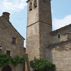
Peña Oroel, Crag and tail formation in Huesca Province, Spain.

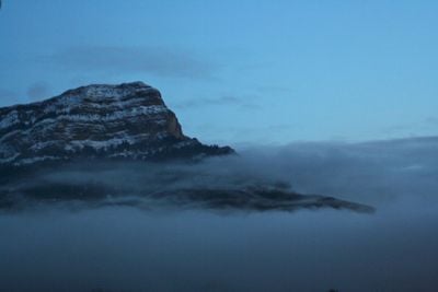
Peña Oroel is a crag and tail formation in Huesca Province that rises to 1,769 meters, distinguished by steep cliffs and a rocky summit visible from many directions across the region. The characteristic shape results from differential erosion, where harder rock layers protect softer materials beneath them.

The summit served for centuries as a strategic vantage point, with fires lit during the Reconquista to signal the start of battles across the landscape. This military use connected the peak's natural elevation to the medieval defensive strategies of the region.

The peak holds religious meaning for local communities, hosting an annual gathering on the Sunday before Christmas led by the Bishop of Huesca. Visitors can witness how the mountain brings people together for spiritual observance tied to the natural landscape.

The hiking route starts at the Mirador de Oroel viewpoint and winds through pine forests with roughly 600 meters of elevation gain before reaching the summit. The terrain is steep throughout, so sturdy footwear and adequate time are essential.

The formation appears distinctly different depending on the angle and elevation from which you view it, making it a favorite subject for photographers exploring the landscape. These shifting perspectives reveal how erosion has shaped the rock's visible form in unexpected ways.

The community of curious travelers

AroundUs brings together thousands of curated places, local tips, and hidden gems, enriched daily by 60,000 contributors worldwide.

Start exploring
Location
Location
Elevation above the sea
1,769 m
GPS coordinates
42.52030,-0.54200
Latest update
December 10, 2025 20:06
« Peña Oroel - Crag and tail formation in Huesca Province, Spain » is provided by Around Us (aroundus.com). Images and texts are derived from Wikimedia project under a Creative Commons license. You are allowed to copy, distribute, and modify copies of this page, under the conditions set by the license, as long as this note is clearly visible.

Discover hidden gems everywhere you go!

From secret cafés to breathtaking viewpoints, skip the crowded tourist spots and find places that match your style. Our app makes it easy with voice search, smart filtering, route optimization, and insider tips from travelers worldwide. Download now for the complete mobile experience.

Around Us App Screenshot

A unique approach to discovering new places

Le Figaro

All the places worth exploring

France Info

A tailor-made excursion in just a few clicks

20 Minutes

Around Us
Travel Guide & Maps
Download

Send to your phone

QR Code
1

Open the camera app on your mobile.

2

Point at the QR code with your camera. A notification will appear.

3

Tap the notification to open the link.