
Tanobato, urban village in Padang Sidempuan City, North Sumatra, Indonesia
Location: Padangsidimpuan Utara
GPS coordinates: 1.39500,99.26300
Latest update: March 5, 2025 13:19

Candi Muara Takus
121.7 km
Toba
144.8 km
Mount Ophir
167 km
Bahal temple
52 km
Pematang Siantar Zoo
174.9 km
Sipisopiso Waterfall
188.5 km
Talamau Mount
167 km
Batang Gadis National Park
80 km
Sipinsur Park Geosite and Pine Forest
112.3 km
T.B. Silalahi Museum Center
107.2 km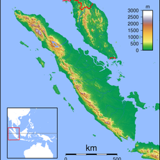
Imun
92.7 km
Dolok Sibualbuali
17.9 km
Museum Pusaka Nias
184.4 km
Simalungun Museum
175.1 km
Batu Gajah megalithic site
157.7 km
Masjid Raya Kajai
155.7 km
Bolon Pematang Purba Cultural House Museum
180 km
Temple de Portibi
45 km
Surau Tuanku Pensiun
155.8 km
Surau Lama Kesultanan Parit Batu
181.3 km
Masjid Al-Abror Lubuk Gobing
112.1 km
Al-Ihsan Limo Koto Mosque
191.7 km
Syekh Muhammad Syaid Mosque
190 km
Surau Lubuak Landua
159.4 km
Masjid Suharto
188.2 km
Surau Kampung Bukit
148.5 km
Masjid Mimba Gadang Pasaman
157.6 km
Batak Tomok Museum
146.8 kmReviews
Visited this place? Tap the stars to rate it and share your experience / photos with the community! Try now! You can cancel it anytime.
Discover hidden gems everywhere you go!
From secret cafés to breathtaking viewpoints, skip the crowded tourist spots and find places that match your style. Our app makes it easy with voice search, smart filtering, route optimization, and insider tips from travelers worldwide. Download now for the complete mobile experience.

A unique approach to discovering new places❞
— Le Figaro
All the places worth exploring❞
— France Info
A tailor-made excursion in just a few clicks❞
— 20 Minutes