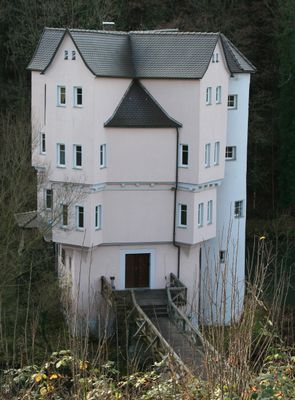
Wasserschloss Lautereck, Water castle near Theusserbad, Löwenstein, Germany
Wasserschloss Lautereck stands on a cross-shaped foundation in a lake fed by a mineral spring, situated beneath the town of Löwenstein in the Sulm valley. The structure is accessed via a footbridge across the surrounding water and remains privately owned by Teusser Mineralbrunnen GmbH.
Count Friedrich Ludwig von Löwenstein commissioned repairs to this summer residence within the spa grounds in 1623, establishing its documented history. The castle subsequently became a central part of the mineral spring resort that drew visitors for generations.
The castle was part of a mineral spring health resort that offered guest rooms and heated baths for visitors seeking therapeutic treatments. This role as a spa facility shaped its character across generations.
The castle is privately owned and cannot be visited from inside, but its exterior can be viewed from the surrounding lake shore and spa grounds. The best views are from the pathways around the resort area and adjacent mineral spring spa grounds.
In January 2009 the castle experienced a smoldering fire, likely caused by chimney heat, which resulted in one person being injured. This incident left an unusual mark on the recent history of the location.
The community of curious travelers
AroundUs brings together thousands of curated places, local tips, and hidden gems, enriched daily by 60,000 contributors worldwide.