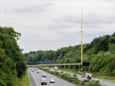
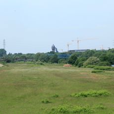
Expo-Brücke, Cable-stayed bridge in Duisburg, Germany
The Expo Bridge is a cable-stayed crossing for pedestrians spanning across a multi-lane expressway with a distinctive yellow tower. Its design features supporting steel cables arranged in a geometric pattern above the walking surface.
The bridge was originally designed by two renowned architects and displayed at an international exhibition in 1958 before moving to Duisburg. It was later rebuilt as a pedestrian crossing over traffic and now stands as a preserved example of postwar modernism.
The bridge reflects a forward-thinking approach to pedestrian movement in 1950s urban design, when such crossings were uncommon. Today it links green spaces that serve both visitors and residents.
The crossing is designed for pedestrians and offers a direct route over traffic with views of the surrounding landscape. It is freely accessible at any time, making it a convenient connection between green areas on either side.
The yellow pylon deliberately tilts to one side, an unusual structural choice that gives the bridge its distinctive appearance. This angled design is not a flaw but an intentional architectural decision that uses the cables' support strategically.
Location: Duisburg
Inception: 1958
Architects: Egon Eiermann, Sep Ruf
GPS coordinates: 51.42710,6.80330
Latest update: December 13, 2025 12:24
Duisburg Zoo
923 m
Duisburg Central Station
1.9 km
Haus Hartenfels
920 m
Kaiserberg
1.2 km
Duisburger Stadtwald
692 m
Museum DKM
2.3 km
City Palais
2.3 kmSolbad Raffelberg
1.9 km
Fraunhofer Institute for Microelectronic Circuits and Systems
502 m
St. Ludger
1.5 km
Botanischer Garten am Kaiserberg
1.1 km
Schleuse Raffelberg
2.3 km
Neandertalweg
672 m
St. Gabriel
1.3 km
St. Michael
2.1 km
Jüdischer Friedhof
1.8 km
Brohler Villa
1.2 km
Lutherische Auferstehungskirche (Duisburg)
2.3 km
Wilhelmshöhe 6, Duisburg
788 m
UCI Kinowelt Duisburg
1.8 km
LSG-Waldgebiet am Kaiserberg, "Schnabelhuck", "Ehrenfriedhof", "Marienborn"
1.2 km
Prinzenhöhe 26, Mülheim
1.2 km
Prinzenhöhe 14, Mülheim
1.2 km
LSG Speldorf - Styrumer Ruhraue
2 km
Landschaftsschutzgebiet Duisburger Stadtwald mit den Bereichen Witzberg, Monning, Wolfsberg, Am Stein, Eselsbruch, Nachtigallental, Uhlenhorst
715 m
Koloniestraße 72
1.7 km
Fahrenkamp extension
820 m
Henle Villa
840 mVisited this place? Tap the stars to rate it and share your experience / photos with the community! Try now! You can cancel it anytime.
Discover hidden gems everywhere you go!
From secret cafés to breathtaking viewpoints, skip the crowded tourist spots and find places that match your style. Our app makes it easy with voice search, smart filtering, route optimization, and insider tips from travelers worldwide. Download now for the complete mobile experience.
A unique approach to discovering new places❞
— Le Figaro
All the places worth exploring❞
— France Info
A tailor-made excursion in just a few clicks❞
— 20 Minutes