Enable Location

We need your location to show you interesting places around you

Discover nearby places

Find interesting locations and hidden gems around you

Precise directions

Get accurate directions and distances to places

Your location is never shared with other users. It's only used when you tap the location button.

Tamasuidō-bashi

Log in to your account

Start exploring — it's free

Trusted by 62,865 travelers worldwide

Continue with Google
Continue with Apple
or

We will send you a code to connect

By continuing, you accept our Terms and Conditions and our Privacy Policy

Check your inbox

We've sent a pincode in your inbox. Please enter the code below.

Tamasuidō-bashi

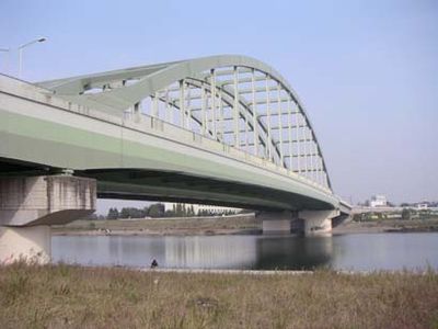
Tamasuidō-bashi, Road bridge in Komae and Tama-ku, Japan.

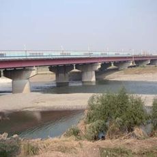
Tamasuidō-bashi is a 358.8 meter arch bridge spanning the Tama River and connecting Komae with Tama-ku. It carries both traffic on its deck and functions as a water channel, with its curved design supporting dual purposes.

Construction started in 1995 and proceeded in stages until completion in 2001. This project was part of Tokyo's broader effort to improve transportation links across the metropolitan area.

The bridge serves as a daily passage for commuters crossing between the districts and has become a familiar landmark in the local landscape. It represents how modern infrastructure shapes the way people move through their neighborhoods.

The bridge carries the Tokyo Metropolitan Road and Kanagawa Prefectural Road Route 3, making it a key link for traffic between the two districts. It remains open daily for vehicle passage and provides the most direct route across the river.

The structure serves three purposes at once: carrying vehicle traffic, allowing water flow through it, and functioning as an arch bridge. This triple-purpose design is uncommon and demonstrates how Japanese engineers solved multiple infrastructure challenges in a single construction.

The community of curious travelers

AroundUs brings together thousands of curated places, local tips, and hidden gems, enriched daily by 60,000 contributors worldwide.

Start exploring
Location
Location
Inception
May 1995
Length
358.8 m
GPS coordinates
35.62556,139.56939
Latest update
December 12, 2025 07:51
« Tamasuidō-bashi - Road bridge in Komae and Tama-ku, Japan » is provided by Around Us (aroundus.com). Images and texts are derived from Wikimedia project under a Creative Commons license. You are allowed to copy, distribute, and modify copies of this page, under the conditions set by the license, as long as this note is clearly visible.

Discover hidden gems everywhere you go!

From secret cafés to breathtaking viewpoints, skip the crowded tourist spots and find places that match your style. Our app makes it easy with voice search, smart filtering, route optimization, and insider tips from travelers worldwide. Download now for the complete mobile experience.

Around Us App Screenshot

A unique approach to discovering new places

Le Figaro

All the places worth exploring

France Info

A tailor-made excursion in just a few clicks

20 Minutes

Around Us
Travel Guide & Maps
Download

Send to your phone

QR Code
1

Open the camera app on your mobile.

2

Point at the QR code with your camera. A notification will appear.

3

Tap the notification to open the link.