Enable Location

We need your location to show you interesting places around you

Discover nearby places

Find interesting locations and hidden gems around you

Precise directions

Get accurate directions and distances to places

Your location is never shared with other users. It's only used when you tap the location button.

灰ヶ峰

Log in to your account

Start exploring — it's free

Trusted by 62,495 travelers worldwide

Continue with Google
Continue with Apple
or

We will send you a code to connect

By continuing, you accept our Terms and Conditions and our Privacy Policy

Check your inbox

We've sent a pincode in your inbox. Please enter the code below.

灰ヶ峰

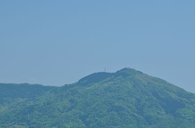
灰ヶ峰, Mountain summit in Kure City, Japan

Haigamine Mountain reaches 737 meters (2,421 feet) and has a rounded summit where a white weather radar dome sits prominently. A parking area at the top gives visitors a place to stop and look out toward the city below.

During World War II, this mountain served as a location for military defense installations protecting the harbor. The observation area that exists today was constructed afterward over these former military foundations.

Local residents connect this site to their identity through the pattern created by city lights at night, which holds special meaning in community folklore. This connection has made it a place where people gather to mark important moments together.

The summit parking area has limited spaces, so visitors should plan their arrival time carefully, especially during sunrise hours. Coming early in the morning or outside peak times offers better chances of finding a spot.

The mountain houses a weather radar station that collects meteorological data for the entire region and supports local safety. This scientific equipment makes the site serve a practical purpose beyond sightseeing.

The community of curious travelers

AroundUs brings together thousands of curated places, local tips, and hidden gems, enriched daily by 60,000 contributors worldwide.

Start exploring
Elevation above the sea
737 m
GPS coordinates
34.27040,132.59338
Latest update
December 10, 2025 16:02
« 灰ヶ峰 - Mountain summit in Kure City, Japan » is provided by Around Us (aroundus.com). Images and texts are derived from Wikimedia project under a Creative Commons license. You are allowed to copy, distribute, and modify copies of this page, under the conditions set by the license, as long as this note is clearly visible.

Discover hidden gems everywhere you go!

From secret cafés to breathtaking viewpoints, skip the crowded tourist spots and find places that match your style. Our app makes it easy with voice search, smart filtering, route optimization, and insider tips from travelers worldwide. Download now for the complete mobile experience.

Around Us App Screenshot

A unique approach to discovering new places

Le Figaro

All the places worth exploring

France Info

A tailor-made excursion in just a few clicks

20 Minutes

Around Us
Travel Guide & Maps
Download

Send to your phone

QR Code
1

Open the camera app on your mobile.

2

Point at the QR code with your camera. A notification will appear.

3

Tap the notification to open the link.