Chest opened
+${chestReward.xp} XP
Explorer
NOUVEAU ×${chestReward.collectible.quantity}
tapez pour fermer

See the monuments around you in AR Open chests in the app

Around Us is built for your phone — point your camera at the streets and discover the monuments and places around you in augmented reality. Around Us is built for your phone — chests unlock when you walk, explore and capture nearby places.

•

Enable Location

We need your location to show you interesting places around you

Discover nearby places

Find interesting locations and hidden gems around you

Precise directions

Get accurate directions and distances to places

Your location is never shared with other users. It's only used when you tap the location button.

Amagoi Dake

Log in to your account

Start exploring — it's free

Trusted by 94,760 travelers worldwide

Continue with Google
Continue with Apple
or

We will send you a code to connect

By continuing, you accept our Terms and Conditions and our Privacy Policy

Check your inbox

We've sent a pincode in your inbox. Please enter the code below.

Amagoi Dake

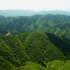
Amagoi Dake, Mountain summit in Shiga Prefecture, Japan

Amagoi Dake is a 1,238 m peak on the border of Higashiōmi and Kōka in Shiga Prefecture, the second-highest summit of the Suzuka Mountains. Its rounded top is covered with dwarf bamboo and holds a small pond, Ōtōge-no-sawa, surrounded by the same bamboo. Below, natural forest mixes with conifer plantations of horse chestnut, rhododendron and oak.

The old Chikusa-goe road crossed the mountain's flanks between Katsuhatake in Shiga and Chigusa in Mie. In 1570, Oda Nobunaga was shot at with a matchlock by Sugitani Zenjūbō in the Fujikiri valley on this route, and escaped; the "Sugitani Zenjūbō hiding rock" stands nearby. From the late Edo period into the Meiji era, six mines on the southern slopes produced silver, copper and lead, and about 300 miners worked at the Mioike mine at its peak.

The name Amagoi Dake comes from a small pond near the summit, fed by the Ōtōge-no-sawa stream, which never dries up. Farmers from downstream villages climbed here to pray for rain, and Shinto rites were held at the pond. The mountain is also called Shirakura-dake and Fujikiri-dake.

Trails reach the summit from the west end of the Buhei Tunnel on National Route 477 (Suzuka Skyline), from Inagatani, from Aotake-dani via the Nenohira and Sugi passes, and from Kōtsubata via the Tsurube-dani junction and Sugi Pass. Sections can be hard to follow through bamboo grass, and Yamabiru leeches appear in summer on routes such as Kōtsubata. Warning signs stand along the Kokui-dani junction to Kura-dani stretch, where walkers often lose the path.

The small pond near the summit, ringed by dwarf bamboo, never dries up and was long the goal of rain-prayer pilgrimages by farmers from downstream. It is now a breeding site for the forest green tree frog.

The community of curious travelers

AroundUs brings together thousands of curated places, local tips, and hidden gems, enriched daily by 94,760 contributors worldwide.

Start exploring
Location
Location
Location
Elevation above the sea
1,237 m
Part of
Suzuka Seven Mountains
GPS coordinates
35.02109,136.38417
Latest update
November 1, 2026 05:06
Reviews
Share your experience

No review yet

Discussions
Start a discussion...

No discussion yet

« Amagoi Dake - Mountain summit in Shiga Prefecture, Japan » is provided by Around Us (aroundus.com). Images and texts are derived from Wikimedia project under a Creative Commons license. You are allowed to copy, distribute, and modify copies of this page, under the conditions set by the license, as long as this note is clearly visible.

Discover hidden gems everywhere you go!

From secret cafés to breathtaking viewpoints, skip the crowded tourist spots and find places that match your style. Our app makes it easy with voice search, smart filtering, route optimization, and insider tips from travelers worldwide. Download now for the complete mobile experience.

Around Us App Screenshot
❝

A unique approach to discovering new places❞

— Le Figaro

❝

All the places worth exploring❞

— France Info

❝

A tailor-made excursion in just a few clicks❞

— 20 Minutes

Around Us
Travel Guide & Maps
Download

Send to your phone

QR Code
1

Open the camera app on your mobile.

2

Point at the QR code with your camera. A notification will appear.

3

Tap the notification to open the link.