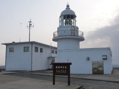
Tappisaki Lighthouse, Maritime lighthouse in Sotogahama, Japan
Tappisaki Lighthouse is a cylindrical brick and concrete tower standing on the northernmost point of Cape Tappi. The structure operates fully automatically today and continues to transmit navigation signals to ships in the area.
The lighthouse was completed in 1932 and received a radio beacon the following year to improve navigation through the Tsugaru Strait. These early technological improvements made it an important aid for maritime traffic in the region.
The lighthouse stands as a symbol of Japan's maritime heritage and draws visitors interested in the country's seafaring traditions. Its location on the northernmost point of the peninsula makes it significant to the local identity.
The lighthouse grounds have been open to visitors since 2005 and offer views of the coast and the strait. The location is exposed and windswept, so visitors should dress appropriately for the maritime setting.
The lighthouse's lighting system was modernized in 1998 with high-intensity technology to remain visible to ships even in harsh weather. This shows how traditional structures are maintained with contemporary methods.
Location: Sotogahama
Location: Aomori Prefecture
Inception: 1932
Height: 13.72 m
Made from material: brick, concrete
GPS coordinates: 41.25849,140.34241
Latest update: December 8, 2025 21:00
Matsumae Castle
27.3 km
Jōmon Prehistoric Sites in Northern Japan
27.8 km
Osamu Dazai Memorial Museum
40.7 km
Yokozuna Chiyonoyama & Chiyonofuji Memorial Museum
25.6 km
Daisengen-dake
38.8 km
Fukushima Town Seikan Tunnel Museum
26.3 km
Tachineputa Museum
50.5 km
Fukushima Castle
23.9 km
Jūnihon-yasu
41.3 km
Tagoyano Shell Mound
41.3 km
Shirakami misaki Lighthouse
19.7 km
Hotoke-ga-ura
39.1 km
Kōzen-ji
27.6 km
Matsumae-Yagoshi Prefectural Natural Park
19.6 km
Chōen-ji
49 kmMonpō-ji
23.8 km
Sannobō Site
21.6 km
Kikonai Town Museum
46.3 kmDaruma Falls
21 km七つ滝
9 km
Matsumae Town Historical Museum
27.6 kmYōshin-ji
39.7 km
Kamegaoka Stone Age Site
41.6 km
Seikan Tunnel Tappi Shakō Line
632 m
Ōdai Yamamoto I Site
27.8 kmŌsawanai Tameike
36.4 kmŌ Tameike
43 kmUshigataō Tameike
35.6 kmVisited this place? Tap the stars to rate it and share your experience / photos with the community! Try now! You can cancel it anytime.
Discover hidden gems everywhere you go!
From secret cafés to breathtaking viewpoints, skip the crowded tourist spots and find places that match your style. Our app makes it easy with voice search, smart filtering, route optimization, and insider tips from travelers worldwide. Download now for the complete mobile experience.
A unique approach to discovering new places❞
— Le Figaro
All the places worth exploring❞
— France Info
A tailor-made excursion in just a few clicks❞
— 20 Minutes