Enable Location

We need your location to show you interesting places around you

Discover nearby places

Find interesting locations and hidden gems around you

Precise directions

Get accurate directions and distances to places

Your location is never shared with other users. It's only used when you tap the location button.

Byk

Log in to your account

Start exploring — it's free

Trusted by 62,001 travelers worldwide

Continue with Google
Continue with Apple
or

We will send you a code to connect

By continuing, you accept our Terms and Conditions and our Privacy Policy

Check your inbox

We've sent a pincode in your inbox. Please enter the code below.

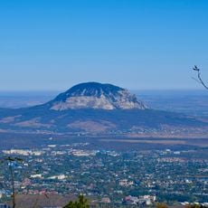
Byk, mountain in Stavropol Krai, Russia

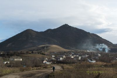
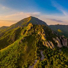
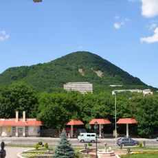
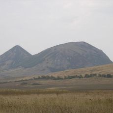
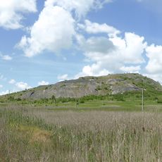
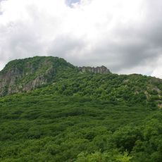
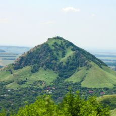
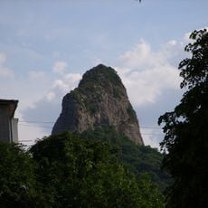
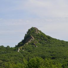
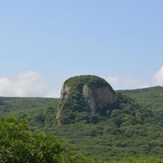
Byk is a mountain and natural monument located in Predgorny District, rising to about 817 meters elevation. Rocky outcrops mark its slopes, which display varied vegetation adapted to different elevations.

The mountain formed as a geological feature and served as a territorial landmark in the North Caucasus from the establishment of Stavropol Krai in 1924. Its position has made it recognizable within the regional landscape for over a century.

Local communities have woven the mountain into regional folklore and oral traditions that reflect their connection to this landscape. Stories passed down through generations often reference its presence in the surrounding territory.

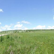
Hiking trails connect various starting points within Predgorny District to the mountain, with spring and autumn offering the most comfortable climbing conditions. Visitors should bring weather-appropriate gear since conditions can change rapidly at elevation.

The mountain contains geological formations with minerals and rock structures of scientific interest to researchers. These features have drawn scholars who study the mineral composition of the North Caucasus region.

The community of curious travelers

AroundUs brings together thousands of curated places, local tips, and hidden gems, enriched daily by 60,000 contributors worldwide.

Start exploring
Location
Elevation above the sea
817 m
GPS coordinates
44.18424,42.96124
Latest update
December 12, 2025 09:06
Around this place
Beshtau
Russian Federation

Beshtau

10.8 km
The place of Lermontov's duel
Russian Federation

The place of Lermontov's duel

16.7 km
Gora Zmeyka
Russian Federation

Gora Zmeyka

10.8 km
Semashko Mudbath, Yessentuki
Russian Federation

Semashko Mudbath, Yessentuki

16.8 km
Emir of Bukhara House
Russian Federation

Emir of Bukhara House

7.8 km
Zheleznaya Mount
Russian Federation

Zheleznaya Mount

7.5 km
Verblyud
Russian Federation

Verblyud

6.1 km
Kinzhal
Russian Federation

Kinzhal

10.6 km
Gora Razvalka
Russian Federation

Gora Razvalka

6.7 km
Gora Sheludivaya
Russian Federation

Gora Sheludivaya

10 km
Constantinogorsk Fortress
Russian Federation

Constantinogorsk Fortress

16.9 km
Medovaya
Russian Federation

Medovaya

6.7 km
Церковь Святого Пантелеимона (Ессентуки)
Russian Federation

Церковь Святого Пантелеимона (Ессентуки)

17.2 km
Komsomolsky Park, Pyatigorsk
Russian Federation

Komsomolsky Park, Pyatigorsk

16.2 km
Мемориал воинской Славы героев Великой Отечественной войны (Пятигорск)
Russian Federation

Мемориал воинской Славы героев Великой Отечественной войны (Пятигорск)

16.2 km
Ostraya
Russian Federation

Ostraya

7.9 km
Mount Kokurtly
Russian Federation

Mount Kokurtly

12.6 km
Kabanka
Russian Federation

Kabanka

7.5 km
Church of the Annunciation
Russian Federation

Church of the Annunciation

14.3 km
Памятник Первым комсомольцам Пятигорска
Russian Federation

Памятник Первым комсомольцам Пятигорска

16.5 km
Церковь Покрова Пресвятой Богородицы (Железноводск)
Russian Federation

Церковь Покрова Пресвятой Богородицы (Железноводск)

7.6 km
Церковь Святого Николая Чудотворца (Минеральные Воды)
Russian Federation

Церковь Святого Николая Чудотворца (Минеральные Воды)

13.6 km
Церковь равноапостольной княгини Ольги (Железноводск)
Russian Federation

Церковь равноапостольной княгини Ольги (Железноводск)

5.9 km
Pyatigorsk Red Cross Colony Ensemble
Russian Federation

Pyatigorsk Red Cross Colony Ensemble

17.6 km
Building of Pyatigorsk Alexandra and George Nurses Community
Russian Federation

Building of Pyatigorsk Alexandra and George Nurses Community

17.6 km
Golitsyn barrack
Russian Federation

Golitsyn barrack

17.6 km
Sheremetiev barrack
Russian Federation

Sheremetiev barrack

17.5 km
Building of lodge of Pyatigorsk Red Cross Colony
Russian Federation

Building of lodge of Pyatigorsk Red Cross Colony

17.5 km
Show the full map
« Byk - mountain in Stavropol Krai, Russia » is provided by Around Us (aroundus.com). Images and texts are derived from Wikimedia project under a Creative Commons license. You are allowed to copy, distribute, and modify copies of this page, under the conditions set by the license, as long as this note is clearly visible.

Discover hidden gems everywhere you go!

From secret cafés to breathtaking viewpoints, skip the crowded tourist spots and find places that match your style. Our app makes it easy with voice search, smart filtering, route optimization, and insider tips from travelers worldwide. Download now for the complete mobile experience.

Around Us App Screenshot

A unique approach to discovering new places

Le Figaro

All the places worth exploring

France Info

A tailor-made excursion in just a few clicks

20 Minutes

Around Us
Travel Guide & Maps
Download

Send to your phone

QR Code
1

Open the camera app on your mobile.

2

Point at the QR code with your camera. A notification will appear.

3

Tap the notification to open the link.