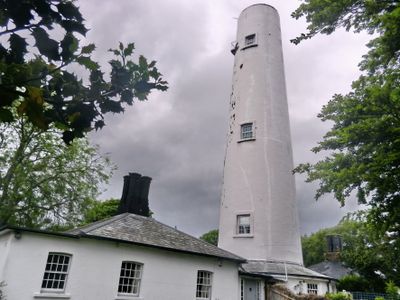
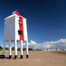
Burnham-on-Sea High Lighthouse, Grade II listed lighthouse in Burnham-on-Sea, England
The Burnham-on-Sea High Lighthouse is a white brick structure rising 30 meters above the Somerset coast, serving as a navigation marker near the River Parrett entrance. The building is now decommissioned, but its distinctive form remains a recognizable landmark along the shoreline.
Trinity House took control of maritime operations in 1829 and subsequently ordered the construction of this lighthouse to guide ships through dangerous sandbanks. Built in 1832, it became essential for protecting vessels navigating the coastal waters.
This structure reflects Somerset's maritime heritage as one of three lighthouses that guided ships entering the Bristol Channel through the River Parrett. Visitors can still sense how important seafaring was to the local community.
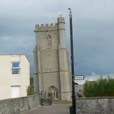
The lighthouse is easy to spot from the Burnham-on-Sea shoreline and can be viewed from various points along the coast. Since the building is protected as a Grade II listed structure, visitors should observe it from a distance and take photographs from outside.
A worker died in a fatal fall during the lighthouse construction in 1832, and local tales speak of mysterious sounds heard during storms near the structure. This tragic incident has given the tower an eerie reputation among residents and visitors over the years.
Location: Burnham-on-Sea and Highbridge
Location: Sedgemoor
Inception: 1832
Height: 30 m
GPS coordinates: 51.24889,-2.99910
Latest update: December 12, 2025 12:07
Brean Leisure Park
4.2 km
Church of St Mary, East Brent
4.3 km
Church of St Mary, Berrow
2.2 km
Church of St Christopher, Lympsham
4.9 km
Brent Knoll
3.8 km
Astro Storm
4.2 km
Brent Knoll Camp
3.8 km
Burnham-on-Sea Low Lighthouse
478 m
St Andrew's Church
1.1 km
Purn Hill
7.5 km
Burnham-on-Sea Round Tower
996 m
Church of St Michael, Brent Knoll
3.2 km
Church of St Bridget
5.6 km
Church of St Peter & St Paul, Bleadon
7.5 km
St Peter and All Hallows Church, West Huntspill
5 km
St Andrew's Church, Steart
5.7 km
Church of All Saints
6.7 km
Rich's Cider Farm
5.5 km
Milepost At Ngr St 3719 5245
7.1 km
Drinking Fountain At The Junction Of Sea View And Berrow Road
829 m
Brent Knoll War Memorial
3.2 km
Milepost At Ngr St 3495 5100
4.6 km
Upper Southwick Farmhouse
5.9 km
Milepost On Roadside At Ngr St 3122 4597
4.6 km
Village Cross, 5 Metres North Of Post Office
7.5 km
Milepost, Church Street, Highbridge, by No. 10
3.5 km
Milestone, Bristol Road, White Cross Crossroads; 50m S of Fox & Goose PH
3.7 km
Milestone, Manor Road (Old Main Road), opp. No. 26,
7.3 kmVisited this place? Tap the stars to rate it and share your experience / photos with the community! Try now! You can cancel it anytime.
Discover hidden gems everywhere you go!
From secret cafés to breathtaking viewpoints, skip the crowded tourist spots and find places that match your style. Our app makes it easy with voice search, smart filtering, route optimization, and insider tips from travelers worldwide. Download now for the complete mobile experience.
A unique approach to discovering new places❞
— Le Figaro
All the places worth exploring❞
— France Info
A tailor-made excursion in just a few clicks❞
— 20 Minutes