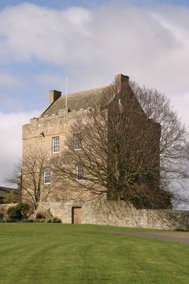
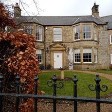
Elsdon Tower, Medieval tower house in Elsdon, England
Elsdon Tower is a stone tower house standing three stories high with substantial walls and a castellated parapet at the top. The structure was designed to serve both defensive and residential purposes for those living within it.
Built in the 15th century as a defensive structure, the tower was converted to serve as a rectory shortly after its construction. This residential function continued for centuries, anchoring the building to the life of the parish.
The tower displays carved family emblems on its parapet, reflecting ties to local noble houses that were patrons of the nearby church. These decorations show how the building was connected to the region's important families.
The tower sits on private property, but its eastern wall can be viewed from the nearby road without needing to enter the property. The best vantage point is near the B6341 road, where the main features are clearly visible.
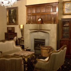
Inside the structure, two original 15th-century features have survived: a garderobe and a fireplace that reveal details of medieval domestic life. These elements offer rare glimpses into how people lived within the tower during that era.
Location: Elsdon
GPS coordinates: 55.23460,-2.10210
Latest update: December 9, 2025 20:20
Otterburn Hall
5.3 km
Elsdon Castle
203 m
Otterburn Mill
4.9 km
Percy Cross
5.9 km
St Cuthbert's Church, Elsdon
107 m
St John the Evangelist's Church, Otterburn
5.1 km
Church of St Cuthbert
6.2 km
East Woodburn Bridge
6.8 km
Milestone, East Otterburn
4.5 km
Milestone Circa 400 Yards North West Of Ottercops Road End
4.8 km
Fountain Base C.80 Yards South Of Otterburn Tower
4.8 km
Tenters C.40 Yards South-East Of Otterburn Mill
4.8 km
Bastle at The Raw Farm
4.7 km
South Lodge to Otterburn Hall
5.1 km
Milestone Circa A Quarter Of A Mile West Of Raylees
2.5 km
Gate And Gateway By South Lodge To Otterburn Hall
5.1 km
Gatepiers, Garden Walls, Railings And Sundial, Circa 30 Yards South Of Overacres
2.8 km
Winter's Gibbet and adjacent crossbase of Steng Cross
3.7 km
The Vicarage
5 km
Milestone C.1/2 Mile West-North-West Of Otterburn
5.9 km
Steng Cross
3.7 km
Bleach House Circa 20 Yards South East Of Otterburn Mills
4.8 km
4 And 5, Bank Foot
4.6 km
Milestone Circa 1000 Yards South Of Blaxter Cottages
3.5 km
Manside defended settlement and medieval cross
5 km
Sundial C.50 Yards South-East Of Otterburn Tower
4.8 km
Bastle, 500m west of High Shaw
4.9 km
Milestone, Raylees
2.5 kmVisited this place? Tap the stars to rate it and share your experience / photos with the community! Try now! You can cancel it anytime.
Discover hidden gems everywhere you go!
From secret cafés to breathtaking viewpoints, skip the crowded tourist spots and find places that match your style. Our app makes it easy with voice search, smart filtering, route optimization, and insider tips from travelers worldwide. Download now for the complete mobile experience.
A unique approach to discovering new places❞
— Le Figaro
All the places worth exploring❞
— France Info
A tailor-made excursion in just a few clicks❞
— 20 Minutes