St Cuthbert's Church, Elsdon

Log in to your account

AroundUs is a community-driven map of interesting places, built by curious explorers like you. It grows with every review, story, and photo you share.
Connect to save your favorite spots, contribute locations, and create personalized routes.
Continue with Google
Continue with Apple
Continue with X
Continue with Facebook
Continue with email
By continuing, you accept our Terms and Conditions and our Privacy Policy
Create an account

St Cuthbert's Church, Elsdon

Add to collection
Map
Suggest a change
Share

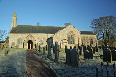
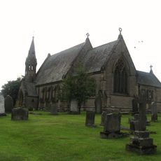
St Cuthbert's Church, Elsdon, Medieval church in Elsdon, England

St Cuthbert's Church is a stone building in Elsdon village with transepts and a bell turret marking its roofline. The structure combines Norman-era portions with later medieval additions, showing how it grew over centuries.

The building took its main form in the 14th century, with earlier Norman foundations from around 1100. Major reconstruction followed the Battle of Otterburn in 1388, reshaping the church we see today.

The church shows cut marks on its arcade pillars where medieval soldiers sharpened their weapons. These marks tell of how military life and religious spaces intersected in this place.

The church is open daily for visitors to explore its architecture and interior details. Its central location in the village makes it easy to find and visit.

During the 1877 restoration, workers found nearly 1000 complete skulls beneath the floor and three horse skulls arranged in a geometric pattern in the bell turret. These unexpected discoveries continue to puzzle researchers about what happened at this place.

Location: Elsdon

Inception: 14 century

GPS coordinates: 55.23372,-2.10143

Latest update: December 14, 2025 17:03

Photos
Around this place
Otterburn Hall
United Kingdom

Otterburn Hall

5.4 km
Elsdon Castle
United Kingdom

Elsdon Castle

256 m
Otterburn Mill
United Kingdom

Otterburn Mill

4.9 km
Elsdon Tower
United Kingdom

Elsdon Tower

107 m
Percy Cross
United Kingdom

Percy Cross

5.9 km
St John the Evangelist's Church, Otterburn
United Kingdom

St John the Evangelist's Church, Otterburn

5.1 km
Church of St Cuthbert
United Kingdom

Church of St Cuthbert

6.1 km
East Woodburn Bridge
United Kingdom

East Woodburn Bridge

6.7 km
Milestone, East Otterburn
United Kingdom

Milestone, East Otterburn

4.6 km
Milestone Circa 400 Yards North West Of Ottercops Road End
United Kingdom

Milestone Circa 400 Yards North West Of Ottercops Road End

4.7 km
Fountain Base C.80 Yards South Of Otterburn Tower
United Kingdom

Fountain Base C.80 Yards South Of Otterburn Tower

4.9 km
Tenters C.40 Yards South-East Of Otterburn Mill
United Kingdom

Tenters C.40 Yards South-East Of Otterburn Mill

4.9 km
Bastle at The Raw Farm
United Kingdom

Bastle at The Raw Farm

4.8 km
South Lodge to Otterburn Hall
United Kingdom

South Lodge to Otterburn Hall

5.2 km
Milestone Circa A Quarter Of A Mile West Of Raylees
United Kingdom

Milestone Circa A Quarter Of A Mile West Of Raylees

2.5 km
Gate And Gateway By South Lodge To Otterburn Hall
United Kingdom

Gate And Gateway By South Lodge To Otterburn Hall

5.2 km
Gatepiers, Garden Walls, Railings And Sundial, Circa 30 Yards South Of Overacres
United Kingdom

Gatepiers, Garden Walls, Railings And Sundial, Circa 30 Yards South Of Overacres

2.8 km
Winter's Gibbet and adjacent crossbase of Steng Cross
United Kingdom

Winter's Gibbet and adjacent crossbase of Steng Cross

3.6 km
The Vicarage
United Kingdom

The Vicarage

5 km
Milestone C.1/2 Mile West-North-West Of Otterburn
United Kingdom

Milestone C.1/2 Mile West-North-West Of Otterburn

5.9 km
Steng Cross
United Kingdom

Steng Cross

3.6 km
Bleach House Circa 20 Yards South East Of Otterburn Mills
United Kingdom

Bleach House Circa 20 Yards South East Of Otterburn Mills

4.9 km
4 And 5, Bank Foot
United Kingdom

4 And 5, Bank Foot

4.6 km
Milestone Circa 1000 Yards South Of Blaxter Cottages
United Kingdom

Milestone Circa 1000 Yards South Of Blaxter Cottages

3.4 km
Manside defended settlement and medieval cross
United Kingdom

Manside defended settlement and medieval cross

5 km
Sundial C.50 Yards South-East Of Otterburn Tower
United Kingdom

Sundial C.50 Yards South-East Of Otterburn Tower

4.8 km
Bastle, 500m west of High Shaw
United Kingdom

Bastle, 500m west of High Shaw

5 km
Milestone, Raylees
United Kingdom

Milestone, Raylees

2.4 km
Show the full map
Reviews

Visited this place? Tap the stars to rate it and share your experience / photos with the community! Try now! You can cancel it anytime.

« St Cuthbert's Church, Elsdon - Medieval church in Elsdon, England » is provided by Around Us (aroundus.com). Images and texts are derived from Wikimedia project under a Creative Commons license. You are allowed to copy, distribute, and modify copies of this page, under the conditions set by the license, as long as this note is clearly visible.

Discover hidden gems everywhere you go!

From secret cafés to breathtaking viewpoints, skip the crowded tourist spots and find places that match your style. Our app makes it easy with voice search, smart filtering, route optimization, and insider tips from travelers worldwide. Download now for the complete mobile experience.

Around Us App Screenshot

A unique approach to discovering new places

Le Figaro

All the places worth exploring

France Info

A tailor-made excursion in just a few clicks

20 Minutes