Kielder Viaduct, Railway viaduct in Northumberland, England.
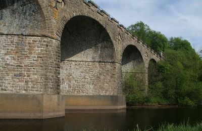
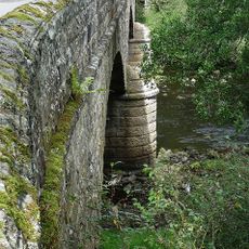
Kielder Viaduct is a railway viaduct in Northumberland featuring seven semi-circular masonry arches angled across the North Tyne River. The structure spans approximately 122 meters at the head of Kielder Water and remains a solid example of 19th-century railway engineering.
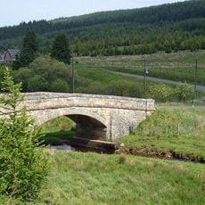
The North British Railway built this viaduct in 1862 as part of the Border Counties Line, a railway route serving the region. Passenger services along this line ended in 1956 and the viaduct remains a protected monument today.
The Duke of Northumberland shaped the design by requesting turrets and battlements to echo the style of his nearby castle. This reflects how railway construction sometimes served the aesthetic preferences of local landowners.
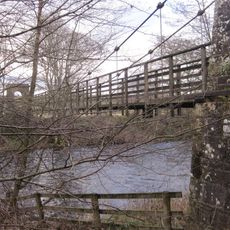
The structure is accessible via footpaths from the forestry car park, which leads to viewing points on the arches. Best visited in dry weather since the paths can be damp and slippery, especially near the river.
Each stone in the viaduct follows helical patterns based on mathematical principles that Peter Nicholson developed for skewed arch construction. This precise stone arrangement allowed the unusual angled arches to span across the river without structural weakness.
Location: Kielder
Inception: 1862
GPS coordinates: 55.22450,-2.57967
Latest update: December 14, 2025 12:22
Kielder Water
6.8 km
Kielder Observatory
2.5 km
Ninestane Rig
12.5 km
Black Middens Bastle House
14.3 km
Catcleugh Reservoir
15.1 km
Whitrope Tunnel
13.9 km
Peel Fell
7.4 km
Dally Castle
16.3 km
Whitrope Siding
13.2 km
Liddel Castle
12.5 km
Churnsike Lodge
15.7 km
Greystead Bridge
15.8 km
Falstone Bridge
10.5 km
Kerseycleugh Bridge
3 km
Devil's Lapful Long Cairn, 1km east of Butteryhaugh Bridge
1.1 km
Butteryhaugh Bridge
458 m
Church of St Luke
15.3 km
Church of St Aidan
16.1 km
St Peter's Church
10.4 km
Whitrope Viaduct
13.1 km
United Reformed Church
10.3 km
Bloodybush Pillar
6.2 km
Milestone Circa 40 Yards South-East Of Ramshope Cottage
15.3 km
Shilla Hill bastle 350m west of Comb
13.3 km
Milestone Circa 40 Yards South-East Of Catcleugh House
16 km
Compensation Arch And Basin At Catcleugh Reservoir
15.8 km
Milestone Circa 1/4 Mile West Of Whitelee
14.9 km
Milestone Circa 100 Yards South-East Of Ramshope Lodge
15 kmVisited this place? Tap the stars to rate it and share your experience / photos with the community! Try now! You can cancel it anytime.
Discover hidden gems everywhere you go!
From secret cafés to breathtaking viewpoints, skip the crowded tourist spots and find places that match your style. Our app makes it easy with voice search, smart filtering, route optimization, and insider tips from travelers worldwide. Download now for the complete mobile experience.
A unique approach to discovering new places❞
— Le Figaro
All the places worth exploring❞
— France Info
A tailor-made excursion in just a few clicks❞
— 20 Minutes