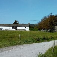
Leighton Moss RSPB reserve, Nature reserve in Lancashire, England
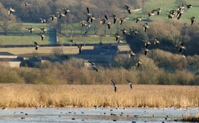
Leighton Moss is a nature reserve in Lancashire with the largest reed bed in northwest England. It provides habitats for waterbirds, otters, and red deer that visitors can explore from seven observation hides connected by trails.
The site was acquired in 1822 by Richard Gillow, who used steam-powered drainage to turn the moss into farmland. When coal prices rose around 1918, this drainage became expensive, water returned to the area, and the land eventually became protected for wildlife.
The name comes from the former landowner Leighton, and the site is now a gathering place for people interested in watching birds and nature. Visitors follow marked paths and use observation hides to see wildlife without disturbing the animals.
The area is easy to walk through, with seven observation hides placed at different spots and maintained paths suitable for different fitness levels. Bring sturdy shoes, as the ground can be soft and muddy, especially after rain.
The reserve is home to rare breeding birds like bitterns and marsh harriers that only appear during certain seasons and are difficult to spot. Visitors who arrive early in the morning have the best chance of seeing these shy species and hearing their calls.
Location: Lancashire
GPS coordinates: 54.16300,-2.80100
Latest update: December 10, 2025 20:07
Carnforth MPD
4 km
Silverdale Hoard
2 km
Leighton Hall, Lancashire
1.6 km
Arnside Tower
3.1 km
Arnside Knott
3.8 km
Hazelwood Hall
1.8 km
St Oswald's Church
2.9 km
Old Rectory
3 km
Lindeth Tower
1.7 km
St Mary's Church, Yealand Conyers
2.6 km
St John's Church, Silverdale
1.8 km
St John the Evangelist's Church, Yealand Conyers
2.9 km
St Oswald Vicarage
3 km
Silverdale Hotel
1.9 km
Dale House
4 km
Chimney On Shore At Jenny Brown's Point
1.5 km
Carnforth: The Coaling Plant
4.1 km
Cinderbarrow Farmhouse
3.9 km
Bradshawgate Farmhouse And Adjoining Barn
2.3 km
Milestone On West Side, South Of Junction With Borwick Lane At Ngr Sd 513 728
3.9 km
Lancaster Canal Yealand Road Bridge (Number 142)
4.1 km
Carnforth Station Junction Signal Box
4 km
Slackwood Farmhouse
375 m
Quaker Meeting House
2.6 km
Former Signal Box, North End Of Platform At Carnforth Station, Ngr Sd 49692 70834
4.1 km
Bank House Farmhouse And Adjoining Barn
2 km
Warton War Memorial, Lancashire
2.9 km
Milestone, Burton Road, Millhead, on bridge over River Keer, just before island for Truckhaven
4 kmVisited this place? Tap the stars to rate it and share your experience / photos with the community! Try now! You can cancel it anytime.
Discover hidden gems everywhere you go!
From secret cafés to breathtaking viewpoints, skip the crowded tourist spots and find places that match your style. Our app makes it easy with voice search, smart filtering, route optimization, and insider tips from travelers worldwide. Download now for the complete mobile experience.
A unique approach to discovering new places❞
— Le Figaro
All the places worth exploring❞
— France Info
A tailor-made excursion in just a few clicks❞
— 20 Minutes