Milecastle 10, Roman fortification in Tyne and Wear, England
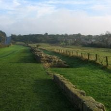
Milecastle 10 is a small Roman fortification with stone walls measuring roughly 19 by 15.5 meters (62 by 51 feet), with sections rising to about 1.75 meters (5.7 feet) in height. The remains show the standard layout of these tiny outposts built along the frontier barrier.
Built as one of roughly 80 similar small forts along Hadrian's Wall, it operated as a control point until the late 300s CE. These outposts played a vital role in watching over and managing the frontier during Rome's occupation of Britain.
Archaeological work uncovered sleeping quarters, storage rooms, and cooking areas that show how soldiers lived and worked here daily. Walking through the remains, you can sense the practical organization needed to keep such a small fort running smoothly.
You can reach this site by walking the Hadrian's Wall Path, a long-distance trail that joins several Roman sites together with clear signage and marked routes. Since the site sits in open countryside, be ready for changing weather and uneven ground underfoot.
Two small watch towers called Turret A and Turret B once stood here, helping soldiers send signals to neighboring forts across the landscape. These extra structures show how the Romans improved visibility and communication along the frontier line.
The community of curious travelers
AroundUs brings together thousands of curated places, local tips, and hidden gems, enriched daily by 60,000 contributors worldwide.