Enable Location

We need your location to show you interesting places around you

Discover nearby places

Find interesting locations and hidden gems around you

Precise directions

Get accurate directions and distances to places

Your location is never shared with other users. It's only used when you tap the location button.

Martholme

Log in to your account

Start exploring — it's free

Trusted by 62,883 travelers worldwide

Continue with Google
Continue with Apple
or

We will send you a code to connect

By continuing, you accept our Terms and Conditions and our Privacy Policy

Check your inbox

We've sent a pincode in your inbox. Please enter the code below.

Discussion Reviews 1 Photos
2.1k Popularity

Martholme, Medieval manor house in Hyndburn, England.

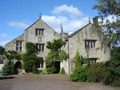
Martholme is a country manor in Hyndburn built from sandstone with slate roofs and a distinctive T-shaped layout. The structure combines medieval timber-framed sections with later stone additions that expanded the house over time.

The manor originated under the de Fitton family in the 13th century and later underwent major rebuilding under the Heskeths. This redesign in the 16th century marked when the house became the family's established home and power base.

The house carries the mark of the Hesketh family who shaped its identity over generations, visible in carved stone emblems throughout the rooms. These family symbols reflect the local power and status that defined life here for centuries.

The house features steps and narrow passages typical of buildings from this era, so sturdy footwear is helpful for exploring. Allow time to move between different levels as you discover the various rooms and sections.

Traces of a medieval moat remain visible around the grounds, revealing how it once protected this settlement. Spotting these earthworks gives a sense of the defensive needs that shaped early manor design.

The community of curious travelers

AroundUs brings together thousands of curated places, local tips, and hidden gems, enriched daily by 60,000 contributors worldwide.

Start exploring
Location
GPS coordinates
53.80000,-2.37680
Latest update
December 13, 2025 17:06
Around this place
Read Hall and Park
United Kingdom

Read Hall and Park

1.1 km
Martholme Viaduct
United Kingdom

Martholme Viaduct

139 m
Portfield hillfort
United Kingdom

Portfield hillfort

1.8 km
St Bartholomew's Church, Great Harwood
United Kingdom

St Bartholomew's Church, Great Harwood

2.2 km
St James' Church, Altham
United Kingdom

St James' Church, Altham

2 km
St John's Church, Great Harwood
United Kingdom

St John's Church, Great Harwood

2.7 km
The Victoria
United Kingdom

The Victoria

2.8 km
Great Harwood Town Hall
United Kingdom

Great Harwood Town Hall

2.6 km
Church of St John Evangelist
United Kingdom

Church of St John Evangelist

1.6 km
Roman Catholic Church of Our Lady and St Hubert, and Attached Presbytery
United Kingdom

Roman Catholic Church of Our Lady and St Hubert, and Attached Presbytery

2.3 km
Clayton-le-Moors Library
United Kingdom

Clayton-le-Moors Library

2.8 km
St Peter's Church, Simonstone
United Kingdom

St Peter's Church, Simonstone

2.3 km
2 Pairs Of Gate Piers With Gates At Entrance Drive To Read Hall
United Kingdom

2 Pairs Of Gate Piers With Gates At Entrance Drive To Read Hall

561 m
Lodge To Read Hall
United Kingdom

Lodge To Read Hall

571 m
Great Harwood War Memorial
United Kingdom

Great Harwood War Memorial

2 km
Gatehouse At Martholme
United Kingdom

Gatehouse At Martholme

34 m
Moor Side House
United Kingdom

Moor Side House

2.4 km
Mercer Memorial Tower
United Kingdom

Mercer Memorial Tower

2.6 km
Altham War Memorial, Lancashire
United Kingdom

Altham War Memorial, Lancashire

2.1 km
Outer Archway At Martholme
United Kingdom

Outer Archway At Martholme

57 m
Icehouse North East Of Read Hall
United Kingdom

Icehouse North East Of Read Hall

1.3 km
Houlker's Farmhouse
United Kingdom

Houlker's Farmhouse

1.8 km
Milestone On South Side Of Road Circa 220 Metres West Of Corner Of Simonstone Lane
United Kingdom

Milestone On South Side Of Road Circa 220 Metres West Of Corner Of Simonstone Lane

2.1 km
Milestone, Burnley Road, Allotment Hall Farm
United Kingdom

Milestone, Burnley Road, Allotment Hall Farm

2.1 km
Milestone, jct with A680, S of tollhouse at traffic lights
United Kingdom

Milestone, jct with A680, S of tollhouse at traffic lights

1.5 km
Milestone, jct Accrington & Burnley Roads
United Kingdom

Milestone, jct Accrington & Burnley Roads

1.6 km
Milestone, N of Rodger Hey
United Kingdom

Milestone, N of Rodger Hey

753 m
Milepost, Whalley Road, W of village, opp. small wood
United Kingdom

Milepost, Whalley Road, W of village, opp. small wood

1.8 km
Show the full map
« Martholme - Medieval manor house in Hyndburn, England » is provided by Around Us (aroundus.com). Images and texts are derived from Wikimedia project under a Creative Commons license. You are allowed to copy, distribute, and modify copies of this page, under the conditions set by the license, as long as this note is clearly visible.

Discover hidden gems everywhere you go!

From secret cafés to breathtaking viewpoints, skip the crowded tourist spots and find places that match your style. Our app makes it easy with voice search, smart filtering, route optimization, and insider tips from travelers worldwide. Download now for the complete mobile experience.

Around Us App Screenshot

A unique approach to discovering new places

Le Figaro

All the places worth exploring

France Info

A tailor-made excursion in just a few clicks

20 Minutes

Around Us
Travel Guide & Maps
Download

Send to your phone

QR Code
1

Open the camera app on your mobile.

2

Point at the QR code with your camera. A notification will appear.

3

Tap the notification to open the link.