Read Hall and Park, Grade II* listed country house in Read, Lancashire, England
Read Hall and Park is a grand country house set on a 450-acre estate in Lancashire that features two lakes, a waterfall, and stretches of woodland. The main building was constructed between 1818 and 1825 by architect George Webster and is surrounded by 25 acres of formal gardens complete with a rockery and fountain.
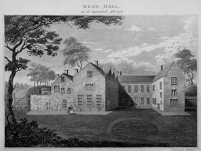
The estate came into the hands of Roger Nowell following the dissolution of Whalley Abbey, and he built the original three-story structure around a courtyard in the 16th century. The current house underwent substantial rebuilding in the early 1800s, transforming the property under new ownership.
The estate witnessed the Battle of Read Bridge in 1643, where Parliamentarian forces secured a decisive victory during the English Civil War.
The house is closed to visitors and can only be viewed from outside the grounds. Being in a rural location, it is worth checking access routes and nearby roads before planning a visit.
A member of the Nowell family who lived at the estate is credited in local tales with discovering the concept of bottled beer while on a fishing trip. This story has become part of regional lore about brewing innovation.
Location: Read
GPS coordinates: 53.80900,-2.37000
Latest update: December 12, 2025 07:54
Huntroyde Hall
2.9 km
Martholme Viaduct
1.1 km
Church of St Mary and All Saints, Whalley
2.8 km
Martholme
1.1 km
Portfield hillfort
1.3 km
St James' Church, Altham
2.2 km
Church of St John Evangelist
845 m
Wiswell Shay Cross
2.8 km
Whalley War Memorial
2.9 km
2 Pairs Of Gate Piers With Gates At Entrance Drive To Read Hall
666 m
St Peter's Church, Simonstone
1.8 km
Vicarage House
2.8 km
Gatehouse At Martholme
1.1 km
Wiswell School War Memorial
2.9 km
Whalley Bridge
2.7 km
Lodge To Read Hall
660 m
Altham War Memorial, Lancashire
2.4 km
Great Harwood War Memorial
2.9 km
Outer Archway At Martholme
1.2 km
Milestone On South Side Of Road Circa 220 Metres West Of Corner Of Simonstone Lane
1.5 km
Three high crosses in St Mary's churchyard
2.8 km
Houlker's Farmhouse
900 m
Icehouse North East Of Read Hall
184 m
Sundial East Of Church Of St Mary And All Saints
2.8 km
Milestone, jct with A680, S of tollhouse at traffic lights
1.2 km
Milestone, jct Accrington & Burnley Roads
1.2 km
Milestone, N of Rodger Hey
1.7 km
Milepost, Whalley Road, W of village, opp. small wood
845 mVisited this place? Tap the stars to rate it and share your experience / photos with the community! Try now! You can cancel it anytime.
Discover hidden gems everywhere you go!
From secret cafés to breathtaking viewpoints, skip the crowded tourist spots and find places that match your style. Our app makes it easy with voice search, smart filtering, route optimization, and insider tips from travelers worldwide. Download now for the complete mobile experience.
A unique approach to discovering new places❞
— Le Figaro
All the places worth exploring❞
— France Info
A tailor-made excursion in just a few clicks❞
— 20 Minutes