Martholme Viaduct, Railway viaduct in Lancashire, England
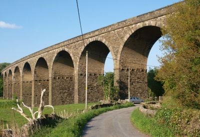
Martholme Viaduct is a railway bridge made of local sandstone that carries tracks across the River Calder between Great Harwood and Read. The structure rests on ten round arches and stands about 20 metres high, making it a prominent feature of the countryside.
Construction began in 1870 and finished in 1877 as part of a railway expansion project for the region. The line itself closed in 1957, but the bridge structure has survived intact to the present day.
The viaduct connects two communities that grew up around the railway line, and its stonework reflects how Victorian engineers shaped the local landscape. Walking beneath it today, you can see how the railway became central to the life of these small towns.
The structure sits away from main roads and is best reached on foot from the nearby river valley. Access is free, and the best time to visit is during dry weather when the paths are easy to walk.
Engineers switched from the original wooden design to local sandstone during construction, giving the structure far greater longevity. This practical adjustment shows how railway projects in the 1800s adapted to the materials available on site.
Location: Hyndburn
Location: Read
Made from material: stone
GPS coordinates: 53.80040,-2.37880
Latest update: December 12, 2025 12:03
Read Hall and Park
1.1 km
Martholme
139 m
Portfield hillfort
1.7 km
St Bartholomew's Church, Great Harwood
2.1 km
St James' Church, Altham
2.2 km
St John's Church, Great Harwood
2.7 km
The Victoria
2.7 km
Great Harwood Town Hall
2.5 km
Church of St John Evangelist
1.7 km
Roman Catholic Church of Our Lady and St Hubert, and Attached Presbytery
2.2 km
2 Pairs Of Gate Piers With Gates At Entrance Drive To Read Hall
520 m
St Peter's Church, Simonstone
2.5 km
Great Harwood War Memorial
1.9 km
Gatehouse At Martholme
146 m
Whalley Bridge
2.8 km
Lodge To Read Hall
530 m
Altham War Memorial, Lancashire
2.3 km
Moor Side House
2.5 km
Mercer Memorial Tower
2.5 km
Outer Archway At Martholme
157 m
Houlker's Farmhouse
1.9 km
Milestone On South Side Of Road Circa 220 Metres West Of Corner Of Simonstone Lane
2.2 km
Icehouse North East Of Read Hall
1.3 km
Milestone, Burnley Road, Allotment Hall Farm
2.2 km
Milestone, jct with A680, S of tollhouse at traffic lights
1.4 km
Milestone, jct Accrington & Burnley Roads
1.5 km
Milestone, N of Rodger Hey
638 m
Milepost, Whalley Road, W of village, opp. small wood
1.8 kmVisited this place? Tap the stars to rate it and share your experience / photos with the community! Try now! You can cancel it anytime.
Discover hidden gems everywhere you go!
From secret cafés to breathtaking viewpoints, skip the crowded tourist spots and find places that match your style. Our app makes it easy with voice search, smart filtering, route optimization, and insider tips from travelers worldwide. Download now for the complete mobile experience.
A unique approach to discovering new places❞
— Le Figaro
All the places worth exploring❞
— France Info
A tailor-made excursion in just a few clicks❞
— 20 Minutes